Hongta District
| Hongta 红塔区 | |
|---|---|
| District | |
 | |
.png) Location of Hongta District (pink) and Yuxi Prefecture (yellow) within Yunnan province of China | |
| Country | People's Republic of China |
| Province | Yunnan |
| Prefecture-level city | Yuxi |
| Area | |
| • Total | 1,004 km2 (388 sq mi) |
| Population | |
| • Total | 380,000 |
| • Density | 380/km2 (980/sq mi) |
| Postal code | 653100 |
| Area code(s) | 0877 |
| Website |
www |
| Yunnan e-Portal | |
Hongta District (simplified Chinese: 红塔区; traditional Chinese: 紅塔區; pinyin: Hóngtǎ Qū) is the main district of Yuxi, Yunnan Province, China.
Government
The county government of Yuxi City is seated in Hongta District.
Ethnic groups
The Yuxi City Almanac (1993:189) lists the following ethnic groups.
References
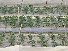
Strawberry fields in Hongta District
External links
Coordinates: 24°20′56″N 102°31′50″E / 24.34889°N 102.53056°E
This article is issued from
Wikipedia.
The text is licensed under Creative Commons - Attribution - Sharealike.
Additional terms may apply for the media files.