Luoping County
| Luoping County 罗平县 | |
|---|---|
| County | |
.png) Location of Luoping County (pink) and Qujing City (yellow) within Yunnan | |
| Country | People's Republic of China |
| Province | Yunnan |
| Prefecture-level city | Qujing |
| Area | |
| • Total | 2,096 km2 (809 sq mi) |
| Population | |
| • Total | 508,345 |
| • Density | 240/km2 (630/sq mi) |
| Time zone | UTC+8 (CST) |
| Postal code | 655800 |
| Area code(s) | 0874 |
| Website |
www |
Luoping County (Chinese: 罗平县; pinyin: Luópíng Xiàn) is located in Qujing City, in eastern Yunnan province, China, bordering Guizhou province to the east and the Guangxi Zhuang Autonmomous Region to the southeast.
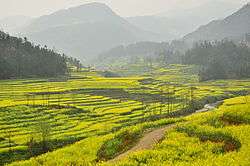
The county of Luoping in eastern Yunnan is noted for its beautiful scenery in spring, when its fields of canola (also known as rapeseed) plants are in full bloom, surrounding the area's mountains with a sea of golden flowers to spectacular effect.
Located near where Yunnan meets Guizhou and Guangxi, Luoping is about 240 kilometers east of Kunming. Not unlike the terraced fields of Yuanyang in southern Yunnan, Luoping's canola fields attract many photographers.
Luoping's golden beauty lasts until late June. During this high travel season for the county regular buses leave from Kunming's bus stations on an almost hourly basis.
Ethnic groups
The Luoping County Almanac (1995:601) lists the following Yi subgroups and their respective locations.
- Wopu 窝普 / Large Black Yi 大黑彝
- Majie town 马街镇: Dayiben 大以本, Jiudaogou 九道沟, Jigu 吉古
- Agang township 阿岗乡: Satuge 洒土格
- Nasupu 纳苏普 / Small Black Yi 小黑彝 (pop. 20,000+)
- Huancheng township 环城乡: Poyi 坡衣
- Fule town 富乐镇: Lefeng 乐丰
- Alu township 阿鲁乡: Qile 启乐, Feige 非格
- Agang township 阿岗乡: Yiyi 以宜
- Jiuwuji township 旧屋基乡: Anmule 安木勒, Muxing 木星, Fawan 法弯, Laozhai 老寨
- Majie town 马街镇: Daimo 歹墨, Luji 鲁基
- Changdi township 长底乡: Deshao 德沙、Bazuo 把佐
- Gepu 戈仆 / Gan Yi 甘/干彝 (pop. 4,300+)
- Huancheng township 环城乡: Zhonghe 中和, Budai 补歹
- Awu 阿武 (pop. 100)
- Huancheng township 环城乡
- Luwu 鲁屋 / White Yi 白彝
Climate
| Climate data for Luoping (1981−2010) | |||||||||||||
|---|---|---|---|---|---|---|---|---|---|---|---|---|---|
| Month | Jan | Feb | Mar | Apr | May | Jun | Jul | Aug | Sep | Oct | Nov | Dec | Year |
| Record high °C (°F) | 25.4 (77.7) |
29.6 (85.3) |
32.3 (90.1) |
34.0 (93.2) |
36.0 (96.8) |
32.9 (91.2) |
31.9 (89.4) |
30.7 (87.3) |
31.3 (88.3) |
29.1 (84.4) |
27.2 (81) |
26.7 (80.1) |
36 (96.8) |
| Average high °C (°F) | 11.8 (53.2) |
14.7 (58.5) |
19.5 (67.1) |
23.9 (75) |
25.4 (77.7) |
25.4 (77.7) |
25.8 (78.4) |
25.7 (78.3) |
23.7 (74.7) |
20.1 (68.2) |
16.8 (62.2) |
13.0 (55.4) |
20.5 (68.9) |
| Daily mean °C (°F) | 6.7 (44.1) |
9.0 (48.2) |
12.9 (55.2) |
17.3 (63.1) |
19.7 (67.5) |
21.0 (69.8) |
21.3 (70.3) |
20.9 (69.6) |
18.9 (66) |
15.8 (60.4) |
11.9 (53.4) |
7.8 (46) |
15.3 (59.5) |
| Average low °C (°F) | 3.4 (38.1) |
5.1 (41.2) |
8.1 (46.6) |
12.3 (54.1) |
15.5 (59.9) |
17.9 (64.2) |
18.4 (65.1) |
17.7 (63.9) |
15.8 (60.4) |
13.1 (55.6) |
8.5 (47.3) |
4.3 (39.7) |
11.7 (53) |
| Record low °C (°F) | −3.5 (25.7) |
−2.3 (27.9) |
−3.6 (25.5) |
−3.0 (26.6) |
4.3 (39.7) |
11.7 (53.1) |
12.7 (54.9) |
11.9 (53.4) |
7.1 (44.8) |
3.1 (37.6) |
−2.6 (27.3) |
−13.5 (7.7) |
−13.5 (7.7) |
| Average precipitation mm (inches) | 27.1 (1.067) |
31.9 (1.256) |
36.0 (1.417) |
49.3 (1.941) |
157.7 (6.209) |
312.0 (12.283) |
340.4 (13.402) |
270.8 (10.661) |
189.0 (7.441) |
115.5 (4.547) |
48.0 (1.89) |
21.9 (0.862) |
1,599.6 (62.976) |
| Average relative humidity (%) | 86 | 79 | 74 | 71 | 76 | 85 | 87 | 87 | 86 | 88 | 86 | 86 | 83 |
| Source: China Meteorological Data Service Center | |||||||||||||
External links
Coordinates: 24°53′06″N 104°18′29″E / 24.88500°N 104.30806°E