County of Cumberland, New South Wales
| Cumberland New South Wales | |||||||||||||||
|---|---|---|---|---|---|---|---|---|---|---|---|---|---|---|---|
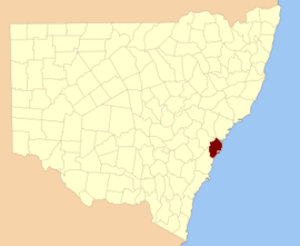 Location in New South Wales | |||||||||||||||
| Established | 4 June 1788 | ||||||||||||||
| |||||||||||||||
Cumberland County is a county in the State of New South Wales, Australia. Most of the Sydney metropolitan area is located within the County of Cumberland.
The County of Cumberland stretches from Broken Bay to the north, the Hawkesbury River to the north-west, the Nepean River to the west, the Cataract River to the south-west and the northern suburbs of Wollongong to the south. It includes the area of the Cumberland Plain.
History
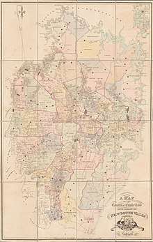
The name Cumberland was conferred by Governor Phillip in honour of Ernest Augustus, Duke of Cumberland, later King of Hanover, at a gathering to celebrate the birthday of his father, King George III, on 4 June 1788.[1] The county has been marked on maps since the start of the colony, as shown along the key on a 1789 map describing Port Jackson as being within the county of Cumberland. In the nineteenth century, parts of the county were in the South and North Riding electoral districts from 1856 to 1859, which were replaced by Central Cumberland. There was also the Cumberland Boroughs electoral district.
Cumberland County Council
The State of New South Wales is divided up into 141 counties, for the purposes of surveying and the registration of land titles. Few Australian counties have ever had any government or administrative function. However, the County of Cumberland did have a county government, the Cumberland County Council, from 1945 to 1964. Its responsibilities were primarily limited to town planning on the metropolitan scale. The Cumberland County Council was not elected by the people, but rather was elected by councillors of the various local governments within the County. The council consisted of 10 councillors each elected to a single constituency: No. 1 (Sydney), No. 2 (Marrickville, Canterbury), No. 3 (Randwick, Botany, Woollahra, Waverley), No. 4 (Rockdale, Hurstville, Kogarah, Sutherland), No. 5 (Strathfield, Ashfield, Burwood, Leichhardt, Drummoyne, Concord), No. 6 (Auburn, Bankstown, Holroyd, Parramatta), No. 7 (Mosman, Manly, North Sydney, Warringah), No. 8 (Hunter's Hill, Hornsby, Ku-ring-gai, Lane Cove, Ryde), No. 9 (Blacktown, Penrith, Baulkham Hills, Windsor) and No. 10 (Fairfield, Camden, Liverpool, Campbelltown, and parts of Wollondilly and Wollongong).[2]
In 1948 the Council published the County of Cumberland planning scheme, a framework for accommodating expected postwar growth in the Sydney Basin. The objectives of the County Council were often in conflict with the aims of many State Government departments. For instance, the County Council's plans called for a green belt to encircle metropolitan Sydney, while the NSW Housing Commission wished to use much of this land to build new low-density public housing estates in areas such as Blacktown and Liverpool. As a result, the Cumberland County Council was dissolved in 1964.
Its metropolitan planning functions were taken over by a new body, the State Planning Authority, which has since been superseded by a succession of state government departments. As of 2011 this government department is the New South Wales Department of Planning and Infrastructure.
Chairmen
| Years | Name | Council | Notes |
|---|---|---|---|
| 1945–1951 | John Percival Tate | Ryde | [3] |
| 1951–1958 | Ronald Stark Luke | Mosman | [4][5] |
| 1958–1960 | Leslie Arthur Scutts | Marrickville | |
| 1960–1961 | Sydney John Webb | Holroyd | |
| 1961–1962 | Tom Foster | Sydney | [6] |
| 1962–1963 | Sydney John Webb | Holroyd | [7] |
| 1963–1964 | Sam Peters |
Hundreds
There were thirteen hundreds in Cumberland County, which were published in a government gazette on 27 May 1835, but repealed on 21 January 1888. Unlike South Australia, the hundreds were never adopted anywhere else in New South Wales. The hundreds:
- Bringelly
- Campbelltown
- Dundas
- Evan
- Hardinge
- Liverpool
- Packenham
- Parramatta
- Richmond
- Southend
- Hundred of Sydney
- Windsor
- Woronora (shown as Heathcote on some maps)
Parishes
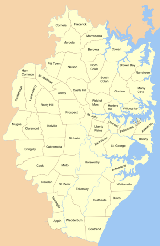
In 1835, Cumberland County was subdivided into 57 parishes.[8] Previously, the subdivisions of the area since the beginning of the colony were called districts. Many of the parishes founded in 1835 kept the name of the district. Others were named after Anglican churches in the same area. This included three of the four small parishes in the Sydney city area; St Philip (named after St.Philip's), St James (named after St. James, and which is still the region name today), St Andrew (named after St. Andrew's). However St Lawrence parish gave its name to the church, rather than the other way around.[9] Further out of the city, the parishes of St John, St Luke, St Peter and St Matthew, in the Parramatta, Liverpool, Campbelltown and Windsor areas respectively, have Anglican churches which bear the same saints names; St John's in Parramatta (opened 1803); St.Luke's in Liverpool (building began 1818); St.Peter's in Campbelltown (opened 1823, the third oldest Anglican church in Australia); and St. Matthew's in Windsor (consecrated in 1822)
A full list of parishes found within this county; the LGA which the parish is mostly in (some are part of several LGAs), and mapping coordinates to the approximate centre of each location is as follows:
Districts
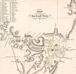
The first subdivisions of the county were called districts, shown in early maps from the period, such as 21 districts on an 1810 map and 37 districts on an 1824 map (not including Philip which was across the Nepean River and not part of the county). The districts in use in 1824:
- Airds
- Appin
- Bankstown
- Bathurst
- Botany Bay
- Bringelly
- Bullanaming
- Cambramatta
- Castle Hill
- Castlereagh
- Concord
- Cooke
- Dundas
- Eastern Plains
- Evan District
- Fields of Mars
- Green Hills
- Holsworth
- Hunter's Hill
- Illawarra
- Liberty Plains
- Mecham
- Melville
- Meyrick
- Minto
- Nelson
- Northern Boundary
- Oxley
- Parramatta
- Petersham
- Ponds
- Prospect
- Richmond
- Sydney
- Tongabee
- Upper Minto
- Upper Nelson
References
- ↑ "Cumberland County". Geographical Names Register (GNR) of NSW. Geographical Names Board of New South Wales.
- ↑ "CUMBERLAND COUNTY". The Sydney Morning Herald (35, 293). New South Wales, Australia. 1 February 1951. p. 4. Retrieved 11 March 2017 – via National Library of Australia.
- ↑ Sarah-Jane Rennie, 'Tate, John Percival (1894–1977)', Australian Dictionary of Biography, National Centre of Biography, Australian National University, http://adb.anu.edu.au/biography/tate-john-percival-11822/text21153, published first in hardcopy 2002, accessed online 11 March 2017.
- ↑ "Councillor R. S. Luke". Construction. New South Wales, Australia. 14 February 1951. p. 3. Retrieved 11 March 2017 – via National Library of Australia.
- ↑ "County Council Chairman's Chain Of Office". The Sydney Morning Herald (36, 054). New South Wales, Australia. 11 July 1953. p. 2. Retrieved 11 March 2017 – via National Library of Australia.
- ↑ "Thomas Christopher Foster". Sydney's Aldermen. City of Sydney. Retrieved 11 March 2017.
- ↑ "Draw decides new chairman". The Biz (2903). New South Wales, Australia. 7 February 1962. p. 3. Retrieved 11 March 2017 – via National Library of Australia.
- ↑ "Names Search". Geographical Names Board of NSW. Archived from the original on 23 March 2007. Retrieved 2 April 2007.
- ↑ The Naming of the Parish, Christ Church of St.Laurence