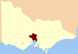
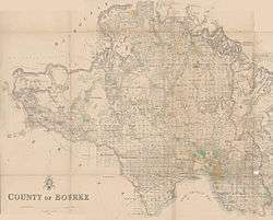
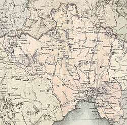
County of Bourke, Victoria

Bourke
Victoria
Location in Victoria
Lands administrative divisions around Bourke:
Talbot Dalhousie Anglesey
Grant Bourke Evelyn
Grant Port Phillip Mornington
1866 map of Bourke County showing the parishes
1885 map of Bourke County (pink)
1886 map of Bourke County

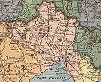
The County of Bourke is one of the 37 counties of Victoria which are part of the Lands administrative divisions of Australia, used for land titles. It is the oldest and most populous county in Victoria and contains the city of Melbourne. Like other counties in Victoria, it is subdivided into parishes. The county was named after Richard Bourke, the governor of New South Wales between 1831 and 1837.[1] It is bordered by the Werribee River in the west, the Great Dividing Range in the north, Port Phillip in the south, and by Dandenong Creek, a small part of the Yarra River, and the Plenty River in the east. The county was proclaimed in 1853.

Unlike counties in England and in the United States, Australian counties serve no administrative or political function. Rather, counties exist for purposes of land ownership. For example, property titles in Lands administrative divisions of Australia are often listed as being situated within a parish and county. For political subdivisions, Australia employs the Local Government Area (LGA) system — which includes shires, districts, and city councils — as the third and lowest tier of government (the States and territories of Australia being the second tier and the Federal Government being the highest tier).

The Melbourne and County of Bourke Police was the name for the police force in the area before 1853. The County of Bourke was used on the name of the electoral roll in 1845.[2] There was also the Bourke County Court in the 1850s,[3] which became the County Court of Victoria. Melbourne is also referenced as being in "Bourke county" in the Encyclopædia Britannica Eleventh Edition.[4]

Parishes

Following is a list of parishes within the County of Bourke. Many of the links below link to a modern suburb or town, which is situated within the parish. In most cases, the parish itself is much bigger than the modern suburb or town.

Several of the parishes are also part of a neighbouring county. For example, Bylands, Forbes, Goldie, Lancefield and Newham parishes are located in the County of Bourke as well as the County of Dalhousie. Morang, Toorourrong and Yan Yean parishes are in the County of Bourke as well as the County of Evelyn. Finally, Ballan parish is situated within both the County of Bourke and the County of Grant.

ParishLGACoordinatesRefMap
BlackwoodShire of Moorabool37°29′57″S 144°19′25″E / 37.49917°S 144.32361°E / -37.49917; 144.32361 (Blackwood)Vicnames
BollindaCity of Hume37°31′57″S 144°47′59″E / 37.53250°S 144.79972°E / -37.53250; 144.79972 (Bollinda)Vicnames
BoroondaraCity of Boroondara37°48′47″S 145°04′04″E / 37.81306°S 145.06778°E / -37.81306; 145.06778 (Boroondara)Vicnames
Bulla BullaCity of Hume37°36′05″S 144°48′42″E / 37.60139°S 144.81167°E / -37.60139; 144.81167 (Bulla Bulla)Vicnames
BulleenCity of Manningham37°45′59″S 145°09′11″E / 37.76639°S 145.15306°E / -37.76639; 145.15306 (Bulleen)Vicnames
BullengarookShire of Macedon Ranges37°30′22″S 144°30′49″E / 37.50611°S 144.51361°E / -37.50611; 144.51361 (Bullengarook)Vicnames
ButtlejorrkCity of Hume37°32′09″S 144°41′21″E / 37.53583°S 144.68917°E / -37.53583; 144.68917 (Buttlejorrk)Vicnames
BylandsShire of Mitchell37°20′44″S 144°58′25″E / 37.34556°S 144.97361°E / -37.34556; 144.97361 (Bylands)Vicnames
ChintinShire of Macedon Ranges37°22′36″S 144°51′11″E / 37.37667°S 144.85306°E / -37.37667; 144.85306 (Chintin)Vicnames
CoimadaiShire of Moorabool37°34′34″S 144°27′25″E / 37.57611°S 144.45694°E / -37.57611; 144.45694 (Coimadai)Vicnames
CoornmillShire of Moorabool37°29′20″S 144°25′33″E / 37.48889°S 144.42583°E / -37.48889; 144.42583 (Coornmill)Vicnames
Cut Paw PawCity of Maribyrnong37°48′32″S 144°52′29″E / 37.80889°S 144.87472°E / -37.80889; 144.87472 (Cut Paw Paw)Vicnames
DandenongCity of Greater Dandenong37°58′18″S 145°11′28″E / 37.97167°S 145.19111°E / -37.97167; 145.19111 (Dandenong)Vicnames
Darraweit GuimShire of Macedon Ranges37°28′00″S 144°53′41″E / 37.46667°S 144.89472°E / -37.46667; 144.89472 (Darraweit Guim)Vicnames
DerrimutCity of Melton37°46′46″S 144°45′03″E / 37.77944°S 144.75083°E / -37.77944; 144.75083 (Derrimut)Vicnames
DeutgamCity of Wyndham37°55′17″S 144°43′42″E / 37.92139°S 144.72833°E / -37.92139; 144.72833 (Deutgam)Vicnames
DjerriwarrhCity of Melton37°40′36″S 144°33′44″E / 37.67667°S 144.56222°E / -37.67667; 144.56222 (Djerriwarrh)Vicnames
Doutta GallaCity of Moonee Valley37°44′56″S 144°54′30″E / 37.74889°S 144.90833°E / -37.74889; 144.90833 (Doutta Galla)Vicnames
ForbesShire of Mitchell37°18′48″S 144°53′16″E / 37.31333°S 144.88778°E / -37.31333; 144.88778 (Forbes)Vicnames
GisborneShire of Macedon Ranges37°29′04″S 144°36′01″E / 37.48444°S 144.60028°E / -37.48444; 144.60028 (Gisborne)Vicnames
GoldieShire of Macedon Ranges37°14′31″S 144°49′32″E / 37.24194°S 144.82556°E / -37.24194; 144.82556 (Goldie)Vicnames
Jika JikaCity of Darebin37°45′02″S 144°59′28″E / 37.75056°S 144.99111°E / -37.75056; 144.99111 (Jika Jika)Vicnames
HavelockShire of Macedon Ranges37°27′16″S 144°48′53″E / 37.45444°S 144.81472°E / -37.45444; 144.81472 (Havelock)Vicnames
HoldenCity of Melton37°37′06″S 144°42′29″E / 37.61833°S 144.70806°E / -37.61833; 144.70806 (Holden)Vicnames
Jika JikaCity of Whittlesea37°45′02″S 144°59′28″E / 37.75056°S 144.99111°E / -37.75056; 144.99111 (Jika Jika)Vicnames
KalkalloCity of Whittlesea37°33′02″S 144°59′51″E / 37.55056°S 144.99750°E / -37.55056; 144.99750 (Kalkallo)Vicnames
KeelbundoraCity of Darebin37°42′53″S 145°03′45″E / 37.71472°S 145.06250°E / -37.71472; 145.06250 (Keelbundora)Vicnames
KerrieShire of Macedon Ranges37°26′00″S 144°41′44″E / 37.43333°S 144.69556°E / -37.43333; 144.69556 (Kerrie)Vicnames
KorkuperrimulShire of Moorabool37°39′09″S 144°24′08″E / 37.65250°S 144.40222°E / -37.65250; 144.40222 (Korkuperrimul)Vicnames
KororoitCity of Melton37°41′50″S 144°38′48″E / 37.69722°S 144.64667°E / -37.69722; 144.64667 (Kororoit)Vicnames
LancefieldShire of Macedon Ranges37°17′01″S 144°44′47″E / 37.28361°S 144.74639°E / -37.28361; 144.74639 (Lancefield)Vicnames
MacedonShire of Macedon Ranges37°24′36″S 144°33′51″E / 37.41000°S 144.56417°E / -37.41000; 144.56417 (Macedon)Vicnames
MaribyrnongCity of Brimbank37°42′45″S 144°46′40″E / 37.71250°S 144.77778°E / -37.71250; 144.77778 (Maribyrnong)Vicnames
Melbourne NorthCity of Yarra37°47′59″S 144°58′46″E / 37.79972°S 144.97944°E / -37.79972; 144.97944 (Melbourne North)Vicnames
Melbourne SouthCity of Port Phillip37°50′11″S 144°57′25″E / 37.83639°S 144.95694°E / -37.83639; 144.95694 (Melbourne South)Vicnames
MerriangCity of Whittlesea37°28′46″S 145°00′27″E / 37.47944°S 145.00750°E / -37.47944; 145.00750 (Merriang)Vicnames
MerrimuShire of Moorabool37°39′13″S 144°29′34″E / 37.65361°S 144.49278°E / -37.65361; 144.49278 (Merrimu)Vicnames
MicklehamCity of Hume37°32′26″S 144°53′50″E / 37.54056°S 144.89722°E / -37.54056; 144.89722 (Mickleham)Vicnames
MonegeettaShire of Macedon Ranges37°22′46″S 144°45′34″E / 37.37944°S 144.75944°E / -37.37944; 144.75944 (Monegeetta)Vicnames
MoorabbinCity of Kingston37°56′29″S 145°02′30″E / 37.94139°S 145.04167°E / -37.94139; 145.04167 (Moorabbin)Vicnames
Moorarbool EastShire of Moorabool37°29′49″S 144°13′11″E / 37.49694°S 144.21972°E / -37.49694; 144.21972 (Moorarbool East)Vicnames
MorangCity of Whittlesea37°38′09″S 145°05′26″E / 37.63583°S 145.09056°E / -37.63583; 145.09056 (Morang)Vicnames
MordiallocCity of Kingston37°57′32″S 145°07′15″E / 37.95889°S 145.12083°E / -37.95889; 145.12083 (Mordialloc)Vicnames
MulgraveCity of Monash37°53′18″S 145°08′52″E / 37.88833°S 145.14778°E / -37.88833; 145.14778 (Mulgrave)Vicnames
MyrniongShire of Moorabool37°36′32″S 144°20′37″E / 37.60889°S 144.34361°E / -37.60889; 144.34361 (Myrniong)Vicnames
NunawadingCity of Whitehorse37°49′41″S 145°09′54″E / 37.82806°S 145.16500°E / -37.82806; 145.16500 (Nunawading)Vicnames
PrahranCity of Glen Eira37°52′38″S 145°02′28″E / 37.87722°S 145.04111°E / -37.87722; 145.04111 (Prahran)Vicnames
PywheitjorrkCity of Melton37°46′09″S 144°38′19″E / 37.76917°S 144.63861°E / -37.76917; 144.63861 (Pywheitjorrk)Vicnames
RochfordShire of Macedon Ranges37°18′44″S 144°40′53″E / 37.31222°S 144.68139°E / -37.31222; 144.68139 (Rochford)Vicnames
SpringfieldShire of Macedon Ranges37°19′29″S 144°48′55″E / 37.32472°S 144.81528°E / -37.32472; 144.81528 (Springfield)Vicnames
TarneitCity of Wyndham37°50′47″S 144°40′38″E / 37.84639°S 144.67722°E / -37.84639; 144.67722 (Tarneit)Vicnames
ToorourrongCity of Whittlesea37°29′31″S 145°06′52″E / 37.49194°S 145.11444°E / -37.49194; 145.11444 (Toorourrong)Vicnames
TruganinaCity of Hobsons Bay37°51′01″S 144°47′06″E / 37.85028°S 144.78500°E / -37.85028; 144.78500 (Truganina)Vicnames
TullamarineCity of Hume37°40′33″S 144°50′45″E / 37.67583°S 144.84583°E / -37.67583; 144.84583 (Tullamarine)Vicnames
Wallan WallanShire of Mitchell37°25′22″S 145°03′43″E / 37.42278°S 145.06194°E / -37.42278; 145.06194 (Wallan Wallan)Vicnames
Will Will RookCity of Hume37°41′15″S 144°56′30″E / 37.68750°S 144.94167°E / -37.68750; 144.94167 (Will Will Rook)Vicnames
WollertCity of Whittlesea37°37′28″S 145°00′05″E / 37.62444°S 145.00139°E / -37.62444; 145.00139 (Wollert)Vicnames
YangardookCity of Melton37°36′02″S 144°35′35″E / 37.60056°S 144.59306°E / -37.60056; 144.59306 (Yangardook)Vicnames
YurokeCity of Hume37°36′53″S 144°54′35″E / 37.61472°S 144.90972°E / -37.61472; 144.90972 (Yuroke)Vicnames

See also

References

  1. Bourke street Melbourne Archived 2006-10-03 at the Wayback Machine.
  2. State Library of Tasmania, Electoral Rolls
  3. Bourke County Court
  4. Wikisource Chisholm, Hugh, ed. (1911). "Melbourne". Encyclopædia Britannica. 18 (11th ed.). Cambridge University Press. p. 90.

Coordinates: 37°35′S 144°50′E / 37.583°S 144.833°E / -37.583; 144.833

This article is issued from Wikipedia. The text is licensed under Creative Commons - Attribution - Sharealike. Additional terms may apply for the media files.