Lincoln County, New South Wales

Lincoln
New South Wales
Location in New South Wales
Lands administrative divisions around Lincoln:
Ewenmar Gowen Napier
Narromine Lincoln Bligh
Gordon Bligh Bligh

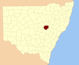
Lincoln County is one of the 141 Cadastral divisions of New South Wales. It contains Dubbo.

Lincoln County was named in honour of Henry Fiennes Pelham Clinton, 5th Duke of Newcastle (1811-1864), styled Earl of Lincoln.[1]

Parishes within this county

A full list of parishes found within this county; their current LGA and mapping coordinates to the approximate centre of each location is as follows:

ParishLGACoordinates
AdelyneWarrumbungle Shire32°00′54″S 149°16′04″E / 32.01500°S 149.26778°E / -32.01500; 149.26778 (Adelyne)
Bald HillDubbo Regional Council32°13′54″S 149°01′04″E / 32.23167°S 149.01778°E / -32.23167; 149.01778 (Bald Hill)
BallimoreDubbo Regional Council32°07′54″S 148°55′04″E / 32.13167°S 148.91778°E / -32.13167; 148.91778 (Ballimore)
BarbigalDubbo Regional Council32°12′54″S 148°49′04″E / 32.21500°S 148.81778°E / -32.21500; 148.81778 (Barbigal)
BeniDubbo Regional Council32°14′54″S 148°45′04″E / 32.24833°S 148.75111°E / -32.24833; 148.75111 (Beni)
BickanbeenieDubbo Regional Council32°01′54″S 148°46′04″E / 32.03167°S 148.76778°E / -32.03167; 148.76778 (Bickanbeenie)
BlackheathWarrumbungle Shire32°07′54″S 149°15′04″E / 32.13167°S 149.25111°E / -32.13167; 149.25111 (Blackheath)
BodangoraDubbo Regional Council32°26′54″S 149°05′04″E / 32.44833°S 149.08444°E / -32.44833; 149.08444 (Bodangora)
BolaroWarrumbungle Shire32°03′54″S 149°22′04″E / 32.06500°S 149.36778°E / -32.06500; 149.36778 (Bolaro)
BoomleyWarrumbungle Shire32°04′54″S 149°04′04″E / 32.08167°S 149.06778°E / -32.08167; 149.06778 (Boomley)
BostonWarrumbungle Shire32°01′54″S 149°10′04″E / 32.03167°S 149.16778°E / -32.03167; 149.16778 (Boston)
Breelong SouthDubbo Regional Council31°59′54″S 148°58′04″E / 31.99833°S 148.96778°E / -31.99833; 148.96778 (Breelong South)
BreelongGilgandra Shire31°51′54″S 149°00′04″E / 31.86500°S 149.00111°E / -31.86500; 149.00111 (Breelong)
BruahDubbo Regional Council32°07′54″S 148°44′04″E / 32.13167°S 148.73444°E / -32.13167; 148.73444 (Bruah)
BulladoranDubbo Regional Council31°59′54″S 148°54′04″E / 31.99833°S 148.90111°E / -31.99833; 148.90111 (Bulladoran)
BullindaWarrumbungle Shire31°54′54″S 149°29′04″E / 31.91500°S 149.48444°E / -31.91500; 149.48444 (Bullinda)
BungiebomarWarrumbungle Shire32°18′54″S 149°09′04″E / 32.31500°S 149.15111°E / -32.31500; 149.15111 (Bungiebomar)
CaledoniaDubbo Regional Council31°59′54″S 148°40′04″E / 31.99833°S 148.66778°E / -31.99833; 148.66778 (Caledonia)
Dubbo Regional CouncilDubbo Regional Council32°16′08″S 148°38′26″E / 32.26889°S 148.64056°E / -32.26889; 148.64056 (Dubbo Regional Council)
CobboraWarrumbungle Shire32°04′54″S 149°16′04″E / 32.08167°S 149.26778°E / -32.08167; 149.26778 (Cobbora)
CobrauraguyDubbo Regional Council32°12′54″S 149°09′04″E / 32.21500°S 149.15111°E / -32.21500; 149.15111 (Cobrauraguy)
CoolbaggieDubbo Regional Council32°07′54″S 148°31′04″E / 32.13167°S 148.51778°E / -32.13167; 148.51778 (Coolbaggie)
DaleyDubbo Regional Council32°02′54″S 148°33′04″E / 32.04833°S 148.55111°E / -32.04833; 148.55111 (Daley)
DapperWarrumbungle Shire32°12′54″S 149°15′04″E / 32.21500°S 149.25111°E / -32.21500; 149.25111 (Dapper)
DewarDubbo Regional Council32°01′54″S 148°51′04″E / 32.03167°S 148.85111°E / -32.03167; 148.85111 (Dewar)
DonellyDubbo Regional Council31°56′54″S 148°46′04″E / 31.94833°S 148.76778°E / -31.94833; 148.76778 (Donelly)
DunedooWarrumbungle Shire32°00′24″S 149°21′04″E / 32.00667°S 149.35111°E / -32.00667; 149.35111 (Dunedoo)
Elong ElongDubbo Regional Council32°10′54″S 149°02′04″E / 32.18167°S 149.03444°E / -32.18167; 149.03444 (Elong Elong)
ErskineDubbo Regional Council32°08′54″S 148°50′04″E / 32.14833°S 148.83444°E / -32.14833; 148.83444 (Erskine)
GambaWarrumbungle Shire32°04′54″S 149°09′04″E / 32.08167°S 149.15111°E / -32.08167; 149.15111 (Gamba)
GeurieDubbo Regional Council32°24′54″S 148°49′04″E / 32.41500°S 148.81778°E / -32.41500; 148.81778 (Geurie)
GoonooDubbo Regional Council32°03′54″S 148°39′04″E / 32.06500°S 148.65111°E / -32.06500; 148.65111 (Goonoo)
LincolnGilgandra Shire31°52′54″S 148°49′04″E / 31.88167°S 148.81778°E / -31.88167; 148.81778 (Lincoln)
MacquarieDubbo Regional Council32°20′24″S 148°49′34″E / 32.34000°S 148.82611°E / -32.34000; 148.82611 (Macquarie)
MedwayDubbo Regional Council32°09′54″S 149°10′04″E / 32.16500°S 149.16778°E / -32.16500; 149.16778 (Medway)
MicketymulgaDubbo Regional Council32°26′54″S 148°53′04″E / 32.44833°S 148.88444°E / -32.44833; 148.88444 (Micketymulga)
MirrieWarrumbungle Shire32°00′54″S 149°04′04″E / 32.01500°S 149.06778°E / -32.01500; 149.06778 (Mirrie)
MitchellDubbo Regional Council32°22′54″S 149°07′04″E / 32.38167°S 149.11778°E / -32.38167; 149.11778 (Mitchell)
MurrumbidgerieDubbo Regional Council32°26′54″S 148°44′04″E / 32.44833°S 148.73444°E / -32.44833; 148.73444 (Murrumbidgerie)
MurrungundieDubbo Regional Council32°11′54″S 148°55′04″E / 32.19833°S 148.91778°E / -32.19833; 148.91778 (Murrungundie)
NarranDubbo Regional Council32°08′54″S 149°02′04″E / 32.14833°S 149.03444°E / -32.14833; 149.03444 (Narran)
RichardsonWarrumbungle Shire31°51′54″S 149°03′04″E / 31.86500°S 149.05111°E / -31.86500; 149.05111 (Richardson)
Spring CreekDubbo Regional Council32°02′54″S 148°57′04″E / 32.04833°S 148.95111°E / -32.04833; 148.95111 (Spring Creek)
TaylorWarrumbungle Shire31°54′54″S 149°17′04″E / 31.91500°S 149.28444°E / -31.91500; 149.28444 (Taylor)
TenandraDubbo Regional Council32°19′54″S 148°59′04″E / 32.33167°S 148.98444°E / -32.33167; 148.98444 (Tenandra)
TerramungamineDubbo Regional Council32°08′54″S 148°39′04″E / 32.14833°S 148.65111°E / -32.14833; 148.65111 (Terramungamine)
TucklandWarrumbungle Shire32°12′54″S 149°20′04″E / 32.21500°S 149.33444°E / -32.21500; 149.33444 (Tuckland)
WallarooWarrumbungle Shire31°52′54″S 149°10′04″E / 31.88167°S 149.16778°E / -31.88167; 149.16778 (Wallaroo)
WarrieDubbo Regional Council32°20′54″S 148°39′34″E / 32.34833°S 148.65944°E / -32.34833; 148.65944 (Warrie)
WoorooboomiDubbo Regional Council32°20′54″S 148°55′04″E / 32.34833°S 148.91778°E / -32.34833; 148.91778 (Woorooboomi)
YarinduryDubbo Regional Council32°15′54″S 148°55′04″E / 32.26500°S 148.91778°E / -32.26500; 148.91778 (Yarindury)
YarrowWarrumbungle Shire32°07′54″S 149°21′04″E / 32.13167°S 149.35111°E / -32.13167; 149.35111 (Yarrow)

See also

References

  1. "Lincoln County". Geographical Names Register (GNR) of NSW. Geographical Names Board of New South Wales.
This article is issued from Wikipedia. The text is licensed under Creative Commons - Attribution - Sharealike. Additional terms may apply for the media files.