Pottinger County

Pottinger
New South Wales
Location in New South Wales
Lands administrative divisions around Pottinger:
White Nandewar Nandewar
Gowen Pottinger Buckland
Napier Bligh Brisbane

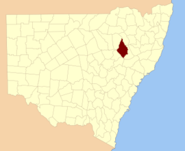
Pottinger County is one of the 141 Cadastral divisions of New South Wales. It is located to the south west of the Namoi River and Mooki River, near Gunnedah.

Pottinger County was named in honour of the first Governor of Hong Kong Sir Henry Pottinger, first Baronet (1789-1856).[1]

Parishes

A full list of parishes found within this county; their current local government areas of Australia (LGA) and mapping coordinates to the approximate centre of each location is as follows:

ParishLGACoordinates
Baan BaaNarrabri Shire30°36′54″S 150°01′04″E / 30.61500°S 150.01778°E / -30.61500; 150.01778 (Baan Baa Parish)
BandoGunnedah Shire31°08′54″S 150°00′04″E / 31.14833°S 150.00111°E / -31.14833; 150.00111 (Bando Parish)
BenelabriGunnedah Shire30°55′54″S 150°00′04″E / 30.93167°S 150.00111°E / -30.93167; 150.00111 (Benelabri Parish)
BingleGunnedah Shire31°14′54″S 149°51′04″E / 31.24833°S 149.85111°E / -31.24833; 149.85111 (Bingle Parish)
Black JackGunnedah Shire31°02′54″S 150°14′04″E / 31.04833°S 150.23444°E / -31.04833; 150.23444 (Black Jack Parish)
BoggabriNarrabri Shire30°41′54″S 150°00′04″E / 30.69833°S 150.00111°E / -30.69833; 150.00111 (Boggabri Parish)
BomeraWarrumbungle Shire31°28′54″S 149°51′04″E / 31.48167°S 149.85111°E / -31.48167; 149.85111 (Bomera Parish)
BreezaGunnedah Shire31°13′54″S 150°24′04″E / 31.23167°S 150.40111°E / -31.23167; 150.40111 (Breeza Parish)
BrennanWarrumbungle Shire31°40′54″S 149°54′04″E / 31.68167°S 149.90111°E / -31.68167; 149.90111 (Brennan Parish)
BrigalowWarrumbungle Shire30°59′54″S 149°45′04″E / 30.99833°S 149.75111°E / -30.99833; 149.75111 (Brigalow Parish)
BrothersGunnedah Shire31°14′54″S 150°11′04″E / 31.24833°S 150.18444°E / -31.24833; 150.18444 (Brothers Parish)
BrownGunnedah Shire31°11′54″S 150°12′04″E / 31.19833°S 150.20111°E / -31.19833; 150.20111 (Brown Parish)
BulgaWarrumbungle Shire31°14′54″S 149°42′04″E / 31.24833°S 149.70111°E / -31.24833; 149.70111 (Bulga Parish)
BundellaLiverpool Plains Shire31°38′54″S 149°57′04″E / 31.64833°S 149.95111°E / -31.64833; 149.95111 (Bundella Parish)
CalalaGunnedah Shire31°14′54″S 150°03′04″E / 31.24833°S 150.05111°E / -31.24833; 150.05111 (Calala Parish)
ClarkeWarrumbungle Shire31°34′54″S 149°51′04″E / 31.58167°S 149.85111°E / -31.58167; 149.85111 (Clarke Parish)
CliftGunnedah Shire31°17′54″S 150°21′04″E / 31.29833°S 150.35111°E / -31.29833; 150.35111 (Clift Parish)
CoogalWarrumbungle Shire31°00′54″S 149°52′04″E / 31.01500°S 149.86778°E / -31.01500; 149.86778 (Coogal Parish)
CoolanbillaLiverpool Plains Shire31°24′54″S 150°08′04″E / 31.41500°S 150.13444°E / -31.41500; 150.13444 (Coolanbilla Parish)
Coomoo CoomooLiverpool Plains Shire31°39′54″S 150°08′04″E / 31.66500°S 150.13444°E / -31.66500; 150.13444 (Coomoo Coomoo Parish)
CurlewisGunnedah Shire31°08′54″S 151°20′04″E / 31.14833°S 151.33444°E / -31.14833; 151.33444 (Curlewis Parish)
Denison WestNarrabri Shire30°52′54″S 149°43′04″E / 30.88167°S 149.71778°E / -30.88167; 149.71778 (Denison West Parish)
DenisonGunnedah Shire30°52′54″S 149°52′04″E / 30.88167°S 149.86778°E / -30.88167; 149.86778 (Denison Parish)
DigbyGunnedah Shire31°07′54″S 150°12′04″E / 31.13167°S 150.20111°E / -31.13167; 150.20111 (Digby Parish)
DoonaGunnedah Shire31°20′54″S 150°20′04″E / 31.34833°S 150.33444°E / -31.34833; 150.33444 (Doona Parish)
DubbledaGunnedah Shire30°50′54″S 150°06′04″E / 30.84833°S 150.10111°E / -30.84833; 150.10111 (Dubbleda Parish)
GarrawillaWarrumbungle Shire31°07′54″S 149°40′04″E / 31.13167°S 149.66778°E / -31.13167; 149.66778 (Garrawilla Parish)
GhoolendaadiGunnedah Shire30°50′54″S 149°59′04″E / 30.84833°S 149.98444°E / -30.84833; 149.98444 (Ghoolendaadi Parish)
GillGunnedah Shire31°01′54″S 150°08′04″E / 31.03167°S 150.13444°E / -31.03167; 150.13444 (Gill Parish)
GoallyWarrumbungle Shire31°06′54″S 149°49′04″E / 31.11500°S 149.81778°E / -31.11500; 149.81778 (Goally Parish)
GoragillaWarrumbungle Shire31°16′54″S 149°40′04″E / 31.28167°S 149.66778°E / -31.28167; 149.66778 (Goragilla Parish)
GoranGunnedah Shire31°11′54″S 150°04′04″E / 31.19833°S 150.06778°E / -31.19833; 150.06778 (Goran Parish)
GulligalNarrabri Shire30°44′54″S 150°02′04″E / 30.74833°S 150.03444°E / -30.74833; 150.03444 (Gulligal Parish)
GunnedahGunnedah Shire30°59′54″S 150°10′04″E / 30.99833°S 150.16778°E / -30.99833; 150.16778 (Gunnedah Parish)
Howes HillLiverpool Plains Shire31°14′54″S 150°08′04″E / 31.24833°S 150.13444°E / -31.24833; 150.13444 (Howes Hill Parish)
JohnstonGunnedah Shire31°04′54″S 150°20′04″E / 31.08167°S 150.33444°E / -31.08167; 150.33444 (Johnston Parish)
KickerbellLiverpool Plains Shire31°29′54″S 150°21′04″E / 31.49833°S 150.35111°E / -31.49833; 150.35111 (Kickerbell Parish)
LawsonLiverpool Plains Shire31°32′54″S 150°00′04″E / 31.54833°S 150.00111°E / -31.54833; 150.00111 (Lawson Parish)
MelvilleGunnedah Shire30°59′54″S 150°00′04″E / 30.99833°S 150.00111°E / -30.99833; 150.00111 (Melville Parish)
MemaLiverpool Plains Shire31°29′54″S 150°05′04″E / 31.49833°S 150.08444°E / -31.49833; 150.08444 (Mema Parish)
MerrigulaGunnedah Shire31°16′54″S 149°55′04″E / 31.28167°S 149.91778°E / -31.28167; 149.91778 (Merrigula Parish)
MillieGunnedah Shire30°57′54″S 150°04′04″E / 30.96500°S 150.06778°E / -30.96500; 150.06778 (Millie Parish)
MoredevilLiverpool Plains Shire32°38′54″S 150°04′04″E / 32.64833°S 150.06778°E / -32.64833; 150.06778 (Moredevil Parish)
Mucca MuccaWarrumbungle Shire31°15′54″S 149°36′04″E / 31.26500°S 149.60111°E / -31.26500; 149.60111 (Mucca Mucca Parish)
NeaGunnedah Shire31°13′54″S 150°17′04″E / 31.23167°S 150.28444°E / -31.23167; 150.28444 (Nea Parish)
NombiWarrumbungle Shire31°10′54″S 149°46′04″E / 31.18167°S 149.76778°E / -31.18167; 149.76778 (Nombi Parish)
PremerWarrumbungle Shire31°25′54″S 149°55′04″E / 31.43167°S 149.91778°E / -31.43167; 149.91778 (Premer Parish)
PringleLiverpool Plains Shire31°32′54″S 150°04′04″E / 31.54833°S 150.06778°E / -31.54833; 150.06778 (Pringle Parish)
RoddLiverpool Plains Shire31°29′54″S 150°12′04″E / 31.49833°S 150.20111°E / -31.49833; 150.20111 (Rodd Parish)
SaltwaterWarrumbungle Shire31°27′54″S 149°47′04″E / 31.46500°S 149.78444°E / -31.46500; 149.78444 (Saltwater Parish)
SpringfieldLiverpool Plains Shire31°25′54″S 150°14′04″E / 31.43167°S 150.23444°E / -31.43167; 150.23444 (Springfield Parish)
TamarangLiverpool Plains Shire31°20′54″S 149°57′04″E / 31.34833°S 149.95111°E / -31.34833; 149.95111 (Tamarang Parish)
TambarWarrumbungle Shire31°22′54″S 149°51′04″E / 31.38167°S 149.85111°E / -31.38167; 149.85111 (Tambar Parish)
TinkrameanahWarrumbungle Shire31°20′54″S 149°39′04″E / 31.34833°S 149.65111°E / -31.34833; 149.65111 (Tinkrameanah Parish)
TrinkeyLiverpool Plains Shire31°24′54″S 150°03′04″E / 31.41500°S 150.05111°E / -31.41500; 150.05111 (Trinkey Parish)
Tulla MullenNarrabri Shire30°37′54″S 149°55′04″E / 30.63167°S 149.91778°E / -30.63167; 149.91778 (Tulla Mullen Parish)
UrangeraWarrumbungle Shire31°16′54″S 149°47′04″E / 31.28167°S 149.78444°E / -31.28167; 149.78444 (Urangera Parish)
Walla Walla WestNarrabri Shire30°45′54″S 149°49′04″E / 30.76500°S 149.81778°E / -30.76500; 149.81778 (Walla Walla West Parish)
Walla WallaNarrabri Shire30°45′54″S 149°55′04″E / 30.76500°S 149.91778°E / -30.76500; 149.91778 (Walla Walla Parish)
WestonLiverpool Plains Shire31°26′54″S 150°23′04″E / 31.44833°S 150.38444°E / -31.44833; 150.38444 (Weston Parish)
WillalaNarrabri Shire30°41′54″S 149°54′04″E / 30.69833°S 149.90111°E / -30.69833; 149.90111 (Willala Parish)
WilsonWarrumbungle Shire31°22′54″S 149°44′04″E / 31.38167°S 149.73444°E / -31.38167; 149.73444 (Wilson Parish)
WondobaGunnedah Shire31°06′54″S 150°05′04″E / 31.11500°S 150.08444°E / -31.11500; 150.08444 (Wondoba Parish)
YarramanLiverpool Plains Shire31°37′54″S 150°12′04″E / 31.63167°S 150.20111°E / -31.63167; 150.20111 (Yarraman Parish)

References

  1. "Pottinger County". Geographical Names Register (GNR) of NSW. Geographical Names Board of New South Wales.
This article is issued from Wikipedia. The text is licensed under Creative Commons - Attribution - Sharealike. Additional terms may apply for the media files.