Baradine County

Baradine
New South Wales
Location in New South Wales
Lands administrative divisions around Baradine:
Finch Denham Jamison
Leichhardt Baradine White
Gowen Gowen Napier

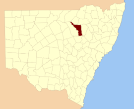
Baradine County is one of the 141 Cadastral divisions of New South Wales. It is bounded in the north by the Namoi River, and includes the land south to Coonabarabran, which is on its southern edge. This includes land on both sides of the Baradine Creek and the town of Baradine.

Baradine is believed to be derived from a local Aboriginal word.[1]

Parishes within the county

A full list of parishes found within this county; their current LGA and mapping coordinates to the approximate centre of each location is as follows:

ParishLGACoordinates
BadhamWarrumbungle Shire30°57′54″S 149°20′04″E / 30.96500°S 149.33444°E / -30.96500; 149.33444 (Badham Parish)
BaradineWarrumbungle Shire30°55′33″S 149°02′34″E / 30.92583°S 149.04278°E / -30.92583; 149.04278 (Baradine Parish)
BarwonWarrumbungle Shire30°59′54″S 148°55′04″E / 30.99833°S 148.91778°E / -30.99833; 148.91778 (Barwon Parish)
BerigerieWarrumbungle Shire30°51′54″S 148°56′04″E / 30.86500°S 148.93444°E / -30.86500; 148.93444 (Berigerie Parish)
BerrybahWalgett Shire30°19′54″S 148°34′04″E / 30.33167°S 148.56778°E / -30.33167; 148.56778 (Berrybah Parish)
BoorimahNarrabri Shire30°04′54″S 149°37′04″E / 30.08167°S 149.61778°E / -30.08167; 149.61778 (Boorimah Parish)
BugaldieWarrumbungle Shire31°05′54″S 149°09′04″E / 31.09833°S 149.15111°E / -31.09833; 149.15111 (Bugaldie Parish)
BullerawaNarrabri Shire30°21′54″S 149°05′04″E / 30.36500°S 149.08444°E / -30.36500; 149.08444 (Bullerawa Parish)
BulliwyWalgett Shire30°30′54″S 148°47′04″E / 30.51500°S 148.78444°E / -30.51500; 148.78444 (Bulliwy Parish)
BundillNarrabri Shire30°10′54″S 149°32′05″E / 30.18167°S 149.53472°E / -30.18167; 149.53472 (Bundill Parish)
Bungle GullyWalgett Shire30°17′54″S 148°30′04″E / 30.29833°S 148.50111°E / -30.29833; 148.50111 (Bungle Gully Parish)
CarloWarrumbungle Shire31°04′54″S 149°20′04″E / 31.08167°S 149.33444°E / -31.08167; 149.33444 (Carlo Parish)
CeelnoyWarrumbungle Shire30°39′54″S 148°52′04″E / 30.66500°S 148.86778°E / -30.66500; 148.86778 (Ceelnoy Parish)
CoolangoolaWarrumbungle Shire30°51′54″S 149°10′04″E / 30.86500°S 149.16778°E / -30.86500; 149.16778 (Coolangoola Parish)
CoomoreNarrabri Shire30°42′54″S 149°13′04″E / 30.71500°S 149.21778°E / -30.71500; 149.21778 (Coomore Parish)
Coomore SouthNarrabri Shire30°46′54″S 149°14′04″E / 30.78167°S 149.23444°E / -30.78167; 149.23444 (Coomore South Parish)
CooperWarrumbungle Shire31°01′54″S 149°15′04″E / 31.03167°S 149.25111°E / -31.03167; 149.25111 (Cooper Parish)
CoxWalgett Shire30°19′54″S 148°26′04″E / 30.33167°S 148.43444°E / -30.33167; 148.43444 (Cox Parish)
CubboNarrabri Shire30°34′54″S 149°07′04″E / 30.58167°S 149.11778°E / -30.58167; 149.11778 (Cubbo Parish)
CulnooyWalgett Shire30°31′54″S 148°36′04″E / 30.53167°S 148.60111°E / -30.53167; 148.60111 (Culnooy Parish)
CumberdoonWalgett Shire30°13′54″S 148°22′04″E / 30.23167°S 148.36778°E / -30.23167; 148.36778 (Cumberdoon Parish)
CumbilNarrabri Shire30°46′54″S 149°09′04″E / 30.78167°S 149.15111°E / -30.78167; 149.15111 (Cumbil Parish)
DandryWarrumbungle Shire31°09′54″S 149°18′04″E / 31.16500°S 149.30111°E / -31.16500; 149.30111 (Dandry Parish)
DangarWalgett Shire30°18′54″S 148°40′04″E / 30.31500°S 148.66778°E / -30.31500; 148.66778 (Dangar Parish)
DenevoliWalgett Shire30°24′54″S 148°31′04″E / 30.41500°S 148.51778°E / -30.41500; 148.51778 (Denevoli Parish)
DoyleWalgett Shire30°07′54″S 148°16′04″E / 30.13167°S 148.26778°E / -30.13167; 148.26778 (Doyle Parish)
DubboNarrabri Shire30°26′54″S 149°06′04″E / 30.44833°S 149.10111°E / -30.44833; 149.10111 (Dubbo Parish)
DunwerianNarrabri Shire30°37′54″S 149°12′04″E / 30.63167°S 149.20111°E / -30.63167; 149.20111 (Dunwerian Parish)
EtooNarrabri Shire30°31′54″S 149°03′04″E / 30.53167°S 149.05111°E / -30.53167; 149.05111 (Etoo Parish)
EuligalNarrabri Shire30°41′54″S 149°05′04″E / 30.69833°S 149.08444°E / -30.69833; 149.08444 (Euligal Parish)
EvansWalgett Shire30°19′54″S 148°20′04″E / 30.33167°S 148.33444°E / -30.33167; 148.33444 (Evans Parish)
GidgenbarCoonamble Shire30°39′54″S 148°46′04″E / 30.66500°S 148.76778°E / -30.66500; 148.76778 (Gidgenbar Parish)
GineeWalgett Shire30°33′54″S 148°41′04″E / 30.56500°S 148.68444°E / -30.56500; 148.68444 (Ginee Parish)
GoangraWalgett Shire30°09′54″S 148°22′04″E / 30.16500°S 148.36778°E / -30.16500; 148.36778 (Goangra Parish)
GoorianawaWarrumbungle Shire31°03′54″S 148°55′04″E / 31.06500°S 148.91778°E / -31.06500; 148.91778 (Goorianawa Parish)
GoraWarrumbungle Shire31°04′54″S 149°00′04″E / 31.08167°S 149.00111°E / -31.08167; 149.00111 (Gora Parish)
GwabegarNarrabri Shire30°35′54″S 148°52′04″E / 30.59833°S 148.86778°E / -30.59833; 148.86778 (Gwabegar Parish)
HallWarrumbungle Shire30°57′54″S 149°05′04″E / 30.96500°S 149.08444°E / -30.96500; 149.08444 (Hall Parish)
JamalongWalgett Shire30°25′54″S 148°26′04″E / 30.43167°S 148.43444°E / -30.43167; 148.43444 (Jamalong Parish)
KenebriWarrumbungle Shire30°49′54″S 148°58′04″E / 30.83167°S 148.96778°E / -30.83167; 148.96778 (Kenebri Parish)
LeslieWarrumbungle Shire31°11′54″S 148°59′04″E / 31.19833°S 148.98444°E / -31.19833; 148.98444 (Leslie Parish)
MackenzieWarrumbungle Shire30°46′54″S 149°04′04″E / 30.78167°S 149.06778°E / -30.78167; 149.06778 (Mackenzie Parish)
McfarlaneWalgett Shire30°13′54″S 148°16′04″E / 30.23167°S 148.26778°E / -30.23167; 148.26778 (Mcfarlane Parish)
MeitWalgett Shire30°25′54″S 148°49′04″E / 30.43167°S 148.81778°E / -30.43167; 148.81778 (Meit Parish)
MerebeneWarrumbungle Shire30°39′54″S 148°58′04″E / 30.66500°S 148.96778°E / -30.66500; 148.96778 (Merebene Parish)
MerimboroughNarrabri Shire30°29′54″S 149°12′04″E / 30.49833°S 149.20111°E / -30.49833; 149.20111 (Merimborough Parish)
MerritombeaWalgett Shire30°03′54″S 148°08′04″E / 30.06500°S 148.13444°E / -30.06500; 148.13444 (Merritombea Parish)
MidgeeWalgett Shire30°29′54″S 148°37′04″E / 30.49833°S 148.61778°E / -30.49833; 148.61778 (Midgee Parish)
MilchomiWalgett Shire30°23′54″S 148°38′04″E / 30.39833°S 148.63444°E / -30.39833; 148.63444 (Milchomi Parish)
MillerWarrumbungle Shire30°44′54″S 148°58′04″E / 30.74833°S 148.96778°E / -30.74833; 148.96778 (Miller Parish)
MinnonNarrabri Shire30°26′54″S 149°01′04″E / 30.44833°S 149.01778°E / -30.44833; 149.01778 (Minnon Parish)
MoglewitNarrabri Shire30°21′54″S 149°00′04″E / 30.36500°S 149.00111°E / -30.36500; 149.00111 (Moglewit Parish)
MuttamaWalgett Shire30°30′54″S 148°31′04″E / 30.51500°S 148.51778°E / -30.51500; 148.51778 (Muttama Parish)
NewmanWalgett Shire30°19′54″S 148°45′04″E / 30.33167°S 148.75111°E / -30.33167; 148.75111 (Newman Parish)
OrrWarrumbungle Shire31°00′55″S 149°30′04″E / 31.01528°S 149.50111°E / -31.01528; 149.50111 (Orr Parish)
ParsonsWarrumbungle Shire30°59′54″S 149°08′04″E / 30.99833°S 149.13444°E / -30.99833; 149.13444 (Parsons Parish)
PilligaWalgett Shire30°19′54″S 148°50′04″E / 30.33167°S 148.83444°E / -30.33167; 148.83444 (Pilliga Parish)
QuegoblaNarrabri Shire30°29′54″S 148°54′04″E / 30.49833°S 148.90111°E / -30.49833; 148.90111 (Quegobla Parish)
RundleWarrumbungle Shire31°08′54″S 149°03′04″E / 31.14833°S 149.05111°E / -31.14833; 149.05111 (Rundle Parish)
TallamaWarrumbungle Shire30°50′54″S 149°05′04″E / 30.84833°S 149.08444°E / -30.84833; 149.08444 (Tallama Parish)
TallubaNarrabri Shire30°20′54″S 148°56′04″E / 30.34833°S 148.93444°E / -30.34833; 148.93444 (Talluba Parish)
TeniNarrabri Shire30°25′54″S 148°54′04″E / 30.43167°S 148.90111°E / -30.43167; 148.90111 (Teni Parish)
TeremboneCoonamble Shire30°38′50″S 148°40′12″E / 30.64722°S 148.67000°E / -30.64722; 148.67000 (Terembone Parish)
TeridgerieWarrumbungle Shire30°48′11″S 148°53′37″E / 30.80306°S 148.89361°E / -30.80306; 148.89361 (Teridgerie Parish)
TunisNarrabri Shire30°21′54″S 149°10′04″E / 30.36500°S 149.16778°E / -30.36500; 149.16778 (Tunis Parish)
UkerbarleyWarrumbungle Shire31°14′54″S 149°08′04″E / 31.24833°S 149.13444°E / -31.24833; 149.13444 (Ukerbarley Parish)
UlambieWalgett Shire30°05′54″S 148°12′04″E / 30.09833°S 148.20111°E / -30.09833; 148.20111 (Ulambie Parish)
UrawilkieCoonamble Shire30°42′54″S 148°45′04″E / 30.71500°S 148.75111°E / -30.71500; 148.75111 (Urawilkie Parish)
WambaduleWalgett Shire30°24′54″S 148°43′04″E / 30.41500°S 148.71778°E / -30.41500; 148.71778 (Wambadule Parish)
WanganNarrabri Shire30°34′54″S 148°58′04″E / 30.58167°S 148.96778°E / -30.58167; 148.96778 (Wangan Parish)
WheohWarrumbungle Shire31°14′54″S 149°04′04″E / 31.24833°S 149.06778°E / -31.24833; 149.06778 (Wheoh Parish)
WhiteWarrumbungle Shire30°43′54″S 148°52′04″E / 30.73167°S 148.86778°E / -30.73167; 148.86778 (White Parish)
WittenbraWarrumbungle Shire31°02′54″S 149°14′04″E / 31.04833°S 149.23444°E / -31.04833; 149.23444 (Wittenbra Parish)
WorigalWarrumbungle Shire30°56′54″S 149°09′04″E / 30.94833°S 149.15111°E / -30.94833; 149.15111 (Worigal Parish)
YarramanCoonamble Shire30°33′54″S 148°47′04″E / 30.56500°S 148.78444°E / -30.56500; 148.78444 (Yarraman Parish)
YarrenWalgett Shire30°31′54″S 148°43′04″E / 30.53167°S 148.71778°E / -30.53167; 148.71778 (Yarren Parish)
YarriganWarrumbungle Shire30°59′54″S 149°00′04″E / 30.99833°S 149.00111°E / -30.99833; 149.00111 (Yarrigan Parish)
YearananWarrumbungle Shire31°08′54″S 148°59′04″E / 31.14833°S 148.98444°E / -31.14833; 148.98444 (Yearanan Parish)

References

  1. "Baradine". Geographical Names Register (GNR) of NSW. Geographical Names Board of New South Wales.
This article is issued from Wikipedia. The text is licensed under Creative Commons - Attribution - Sharealike. Additional terms may apply for the media files.