Tandora County

Tandora
New South Wales
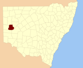
Location in New South Wales
Lands administrative divisions around Tandora:
Mootwingee Mootwingee Young
Yancowinna Tandora Livingstone
Menindee Menindee Livingstone

Tandora County is one of the 141 Cadastral divisions of New South Wales. It is located to the north west of the Darling River, to the area to the north (but not including) Menindee.

The name Tandora is of unknown origin.[1]

Parishes within this county

A full list of parishes found within this county; their current LGA and mapping coordinates to the approximate centre of each location is as follows:

ParishLGACoordinates
BellarUnincorporated32°08′34″S 142°16′15″E / 32.14278°S 142.27083°E / -32.14278; 142.27083 (Bellar)
BurkeUnincorporated31°56′18″S 142°24′03″E / 31.93833°S 142.40083°E / -31.93833; 142.40083 (Burke)
BurnaytoUnincorporated31°44′00″S 142°13′48″E / 31.73333°S 142.23000°E / -31.73333; 142.23000 (Burnayto)
EckerboonUnincorporated31°34′55″S 142°24′09″E / 31.58194°S 142.40250°E / -31.58194; 142.40250 (Eckerboon)
HartungUnincorporated32°17′21″S 142°05′46″E / 32.28917°S 142.09611°E / -32.28917; 142.09611 (Hartung)
HerbertUnincorporated32°00′56″S 142°24′28″E / 32.01556°S 142.40778°E / -32.01556; 142.40778 (Herbert)
HumeCentral Darling Shire32°18′43″S 142°22′37″E / 32.31194°S 142.37694°E / -32.31194; 142.37694 (Hume)
KarsUnincorporated32°15′05″S 142°13′34″E / 32.25139°S 142.22611°E / -32.25139; 142.22611 (Kars)
MaidenCentral Darling Shire32°08′50″S 142°26′36″E / 32.14722°S 142.44333°E / -32.14722; 142.44333 (Maiden)
MalakoffUnincorporated31°52′42″S 142°35′02″E / 31.87833°S 142.58389°E / -31.87833; 142.58389 (Malakoff)
MaltaUnincorporated31°56′28″S 142°03′24″E / 31.94111°S 142.05667°E / -31.94111; 142.05667 (Malta)
Mulga GaariCentral Darling Shire31°57′37″S 142°41′32″E / 31.96028°S 142.69222°E / -31.96028; 142.69222 (Mulga Gaari)
MulgaUnincorporated32°03′22″S 142°16′15″E / 32.05611°S 142.27083°E / -32.05611; 142.27083 (Mulga)
MutlowUnincorporated31°34′59″S 142°33′08″E / 31.58306°S 142.55222°E / -31.58306; 142.55222 (Mutlow)
NadbuckUnincorporated31°34′53″S 142°13′53″E / 31.58139°S 142.23139°E / -31.58139; 142.23139 (Nadbuck)
Nelia GaariCentral Darling Shire
PamamarooCentral Darling Shire32°05′29″S 142°35′06″E / 32.09139°S 142.58500°E / -32.09139; 142.58500 (Pamamaroo)
PattersonUnincorporated31°56′36″S 142°13′40″E / 31.94333°S 142.22778°E / -31.94333; 142.22778 (Patterson)
QuondongUnincorporated32°16′02″S 141°58′40″E / 32.26722°S 141.97778°E / -32.26722; 141.97778 (Quondong)
SilistriaUnincorporated32°08′46″S 142°05′15″E / 32.14611°S 142.08750°E / -32.14611; 142.08750 (Silistria)
SturtUnincorporated31°43′56″S 142°24′07″E / 31.73222°S 142.40194°E / -31.73222; 142.40194 (Sturt)
TandoreCentral Darling Shire32°15′43″S 142°36′27″E / 32.26194°S 142.60750°E / -32.26194; 142.60750 (Tandore)
TitabairaCentral Darling Shire32°15′01″S 142°28′48″E / 32.25028°S 142.48000°E / -32.25028; 142.48000 (Titabaira)
ToparUnincorporated31°44′57″S 142°03′07″E / 31.74917°S 142.05194°E / -31.74917; 142.05194 (Topar)
WeinterigaCentral Darling Shire32°10′01″S 142°39′54″E / 32.16694°S 142.66500°E / -32.16694; 142.66500 (Weinteriga)
WillsUnincorporated31°36′18″S 142°03′32″E / 31.60500°S 142.05889°E / -31.60500; 142.05889 (Wills)
WorungilUnincorporated31°43′42″S 142°32′56″E / 31.72833°S 142.54889°E / -31.72833; 142.54889 (Worungil)

References

  1. "Tandora". Geographical Names Register (GNR) of NSW. Geographical Names Board of New South Wales. Retrieved 4 August 2013.
This article is issued from Wikipedia. The text is licensed under Creative Commons - Attribution - Sharealike. Additional terms may apply for the media files.