Auckland County

Auckland
New South Wales
Location in New South Wales
Lands administrative divisions around Auckland:
Beresford Dampier Pacific Ocean
Wellesley Auckland Pacific Ocean
Croajingolong (Vic) Croajingolong (Vic) Pacific Ocean

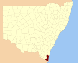
Auckland County is one of the 141 Cadastral divisions of New South Wales. It is at the extreme south-east of the state, with the Victorian border to the south, and the area to the north of the Brogo River the boundary to the north. It includes Bega, Eden and Merimbula.

Auckland County was named in honour of George Eden, who was the First Earl of Auckland between (1784-1849).[1] Coincidentally, the county has the same latitude as the city of Auckland, New Zealand - which was also named for George Eden.

In 1852, it had an area of 1,536,000 acres (6,220 km2) and was described as being mountainous with fertile plains.[2]

Parishes within this county

A full list of parishes found within this county; their current LGA and mapping coordinates to the approximate centre of each location is as follows:

ParishLGACoordinates
BegaBega Valley Shire36°40′54″S 149°54′04″E / 36.68167°S 149.90111°E / -36.68167; 149.90111 (Bega Parish)
BembokaBega Valley Shire36°40′54″S 149°37′04″E / 36.68167°S 149.61778°E / -36.68167; 149.61778 (Bemboka Parish)
BimmilBega Valley Shire36°59′54″S 149°50′04″E / 36.99833°S 149.83444°E / -36.99833; 149.83444 (Bimmil Parish)
BondiSnowy Monaro Regional Council37°06′54″S 149°15′04″E / 37.11500°S 149.25111°E / -37.11500; 149.25111 (Bondi Parish)
BourndaBega Valley Shire36°48′54″S 149°55′04″E / 36.81500°S 149.91778°E / -36.81500; 149.91778 (Bournda Parish)
BoydBega Valley Shire37°00′54″S 149°43′04″E / 37.01500°S 149.71778°E / -37.01500; 149.71778 (Boyd Parish)
BredbendouraBega Valley Shire36°45′54″S 149°30′04″E / 36.76500°S 149.50111°E / -36.76500; 149.50111 (Bredbendoura Parish)
BrogoBega Valley Shire36°37′54″S 149°51′04″E / 36.63167°S 149.85111°E / -36.63167; 149.85111 (Brogo Parish)
BronteBega Valley Shire36°34′54″S 149°45′04″E / 36.58167°S 149.75111°E / -36.58167; 149.75111 (Bronte Parish)
BuckleBega Valley Shire37°18′54″S 149°41′04″E / 37.31500°S 149.68444°E / -37.31500; 149.68444 (Buckle Parish)
BurragateBega Valley Shire36°58′54″S 149°38′04″E / 36.98167°S 149.63444°E / -36.98167; 149.63444 (Burragate Parish)
CandeloBega Valley Shire36°43′54″S 149°45′04″E / 36.73167°S 149.75111°E / -36.73167; 149.75111 (Candelo Parish)
CobraBega Valley Shire36°53′54″S 149°47′04″E / 36.89833°S 149.78444°E / -36.89833; 149.78444 (Cobra Parish)
ColomboBega Valley Shire36°33′54″S 149°26′04″E / 36.56500°S 149.43444°E / -36.56500; 149.43444 (Colombo Parish)
CoolangubraBega Valley Shire36°59′54″S 149°30′04″E / 36.99833°S 149.50111°E / -36.99833; 149.50111 (Coolangubra Parish)
EdenBega Valley Shire37°03′54″S 149°51′04″E / 37.06500°S 149.85111°E / -37.06500; 149.85111 (Eden Parish)
GenoaSnowy Monaro Regional Council37°08′54″S 149°25′04″E / 37.14833°S 149.41778°E / -37.14833; 149.41778 (Genoa Parish)
GnupaBega Valley Shire36°57′54″S 149°47′04″E / 36.96500°S 149.78444°E / -36.96500; 149.78444 (Gnupa Parish)
GooyanBega Valley Shire37°14′54″S 149°47′04″E / 37.24833°S 149.78444°E / -37.24833; 149.78444 (Gooyan Parish)
HoweBega Valley Shire37°21′54″S 149°56′04″E / 37.36500°S 149.93444°E / -37.36500; 149.93444 (Howe Parish)
ImlayBega Valley Shire37°04′54″S 149°44′04″E / 37.08167°S 149.73444°E / -37.08167; 149.73444 (Imlay Parish)
KamerukaBega Valley Shire36°44′54″S 149°50′04″E / 36.74833°S 149.83444°E / -36.74833; 149.83444 (Kameruka Parish)
KanoonahBega Valley Shire36°55′54″S 149°25′04″E / 36.93167°S 149.41778°E / -36.93167; 149.41778 (Kanoonah Parish)
KiahBega Valley Shire37°07′54″S 149°56′04″E / 37.13167°S 149.93444°E / -37.13167; 149.93444 (Kiah Parish)
KokoboreekaBega Valley Shire36°23′54″S 149°35′04″E / 36.39833°S 149.58444°E / -36.39833; 149.58444 (Kokoboreeka Parish)
MataganahBega Valley Shire36°58′54″S 149°34′04″E / 36.98167°S 149.56778°E / -36.98167; 149.56778 (Mataganah Parish)
MeringoBega Valley Shire36°41′54″S 149°46′04″E / 36.69833°S 149.76778°E / -36.69833; 149.76778 (Meringo Parish)
MogilaBega Valley Shire36°41′54″S 149°30′04″E / 36.69833°S 149.50111°E / -36.69833; 149.50111 (Mogila Parish)
MokoreekaBega Valley Shire36°27′54″S 149°31′04″E / 36.46500°S 149.51778°E / -36.46500; 149.51778 (Mokoreeka Parish)
MookerwahBega Valley Shire36°24′54″S 149°43′04″E / 36.41500°S 149.71778°E / -36.41500; 149.71778 (Mookerwah Parish)
MumbullaBega Valley Shire36°29′54″S 149°48′04″E / 36.49833°S 149.80111°E / -36.49833; 149.80111 (Mumbulla Parish)
NalbaughBega Valley Shire37°03′54″S 149°23′04″E / 37.06500°S 149.38444°E / -37.06500; 149.38444 (Nalbaugh Parish)
NarrabarbaBega Valley Shire37°15′54″S 149°53′04″E / 37.26500°S 149.88444°E / -37.26500; 149.88444 (Narrabarba Parish)
NullicaBega Valley Shire37°07′54″S 149°49′04″E / 37.13167°S 149.81778°E / -37.13167; 149.81778 (Nullica Parish)
NumbuggaBega Valley Shire36°38′54″S 149°46′04″E / 36.64833°S 149.76778°E / -36.64833; 149.76778 (Numbugga Parish)
NungattaBega Valley Shire37°12′54″S 149°27′04″E / 37.21500°S 149.45111°E / -37.21500; 149.45111 (Nungatta Parish)
OoranookBega Valley Shire36°33′54″S 149°34′04″E / 36.56500°S 149.56778°E / -36.56500; 149.56778 (Ooranook Parish)
PambulaBega Valley Shire36°52′54″S 149°54′04″E / 36.88167°S 149.90111°E / -36.88167; 149.90111 (Pambula Parish)
PericoeBega Valley Shire37°05′54″S 149°33′04″E / 37.09833°S 149.55111°E / -37.09833; 149.55111 (Pericoe Parish)
Puen BuenBega Valley Shire36°28′54″S 149°45′04″E / 36.48167°S 149.75111°E / -36.48167; 149.75111 (Puen Buen Parish)
SturtBega Valley Shire37°11′54″S 149°42′04″E / 37.19833°S 149.70111°E / -37.19833; 149.70111 (Sturt Parish)
TantawangaloBega Valley Shire36°45′54″S 149°34′04″E / 36.76500°S 149.56778°E / -36.76500; 149.56778 (Tantawangalo Parish)
TowambaBega Valley Shire37°07′54″S 149°42′04″E / 37.13167°S 149.70111°E / -37.13167; 149.70111 (Towamba Parish)
VictoriaBega Valley Shire37°20′54″S 149°52′04″E / 37.34833°S 149.86778°E / -37.34833; 149.86778 (Victoria Parish)
WaalimmaBega Valley Shire37°16′54″S 149°32′04″E / 37.28167°S 149.53444°E / -37.28167; 149.53444 (Waalimma Parish)
WallagaraughBega Valley Shire37°19′54″S 149°45′04″E / 37.33167°S 149.75111°E / -37.33167; 149.75111 (Wallagaraugh Parish)
WallagootBega Valley Shire36°43′54″S 149°56′04″E / 36.73167°S 149.93444°E / -36.73167; 149.93444 (Wallagoot Parish)
Werri BerriBega Valley Shire36°33′45″S 149°30′00″E / 36.56250°S 149.50000°E / -36.56250; 149.50000 (Werri Berri Parish)
WolumlaBega Valley Shire36°48′54″S 149°48′04″E / 36.81500°S 149.80111°E / -36.81500; 149.80111 (Wolumla Parish)
WonboynBega Valley Shire37°12′54″S 149°56′04″E / 37.21500°S 149.93444°E / -37.21500; 149.93444 (Wonboyn Parish)
WyndhamBega Valley Shire36°54′49″S 149°39′43″E / 36.91361°S 149.66194°E / -36.91361; 149.66194 (Wyndham Parish)
YambullaBega Valley Shire37°11′54″S 149°34′04″E / 37.19833°S 149.56778°E / -37.19833; 149.56778 (Yambulla Parish)
YowakaBega Valley Shire36°57′54″S 149°50′34″E / 36.96500°S 149.84278°E / -36.96500; 149.84278 (Yowaka Parish)
YuglamahBega Valley Shire36°52′54″S 149°30′04″E / 36.88167°S 149.50111°E / -36.88167; 149.50111 (Yuglamah Parish)
YurammieBega Valley Shire36°49′54″S 149°40′04″E / 36.83167°S 149.66778°E / -36.83167; 149.66778 (Yurammie Parish)

References

  1. "Auckland County". Geographical Names Register (GNR) of NSW. Geographical Names Board of New South Wales.
  2. "Old Welsh Books with English Translations", The Land of Gold: the Companion for the Welsh Emigrant to Australia, 1852
This article is issued from Wikipedia. The text is licensed under Creative Commons - Attribution - Sharealike. Additional terms may apply for the media files.