Windsor, New South Wales
| Windsor Sydney, New South Wales | |||||||||||||||
|---|---|---|---|---|---|---|---|---|---|---|---|---|---|---|---|
 Tebbutt's Observatory (c. 1879) | |||||||||||||||
|
Windsor | |||||||||||||||
| Coordinates | 33°36′54″S 150°49′02″E / 33.61500°S 150.81722°ECoordinates: 33°36′54″S 150°49′02″E / 33.61500°S 150.81722°E | ||||||||||||||
| Population | 1,891 (2016 census)[1] | ||||||||||||||
| Established | 1791 | ||||||||||||||
| Postcode(s) | 2756 | ||||||||||||||
| Location | 56 km (35 mi) north-west of Sydney CBD | ||||||||||||||
| LGA(s) | City of Hawkesbury | ||||||||||||||
| State electorate(s) | Hawkesbury | ||||||||||||||
| Federal Division(s) | Macquarie | ||||||||||||||
| |||||||||||||||
Windsor is a town lying northwest of Sydney, New South Wales, Australia. Windsor is located in the local government area of the City of Hawkesbury. It sits on the Hawkesbury River, on the north-western outskirts of the Sydney metropolitan area. At the 2016 census, Windsor had a population of 1,891.[1]
History
Prior to European settlement, the area was inhabited by the Dharuk Nation of Aboriginal peoples. Windsor is the third-oldest place of British settlement on the Australian continent. Settlement at the location was first established about 1791, near the head of navigation on the Hawkesbury River (known as Deerubbin in Dharuk) and taking advantage of the fertile river flats for agriculture. The area was originally called Green Hills, but renamed Windsor (after Windsor in England). The town was officially proclaimed in a Government and General Order issued from Government House, Sydney, dated 15 December 1810, Governor Lachlan Macquarie having "marked out the district of Green Hills", which he "... called Windsor", after Windsor-on-the-Thames.
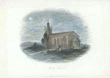
While in Windsor, Macquarie ordered the main institutions of organised settlement to be erected, such as a church, school-house, gaol and "commodious inn" (Macquarie Arms Hotel). Of these new buildings, the most outstanding was Francis Greenway's St Matthew's Anglican Church, for which Macquarie himself chose the site. Samuel Marsden, principal chaplain of the colony, consecrated the church on 8 December 1822.[2]
In 1813 a report was given to Governor Macquarie from Earl Bathurst detailing a proposed invasion of the Hawkesbury River by France.[3] This planned invasion that did not eventuate, targeted the Windsor granary in order to cut off supply to Sydney, showing the relative importance of this new settlement on a global scale.
Windsor is approximately 60 kilometres north-west of Sydney, and the location was chosen because of the agricultural potential of the area and the location was accessible by coastal shipping from Sydney. It was known as the "bread basket", ensuring the survival of the starving colony. The extensive agriculture caused major silting in the Hawkesbury River, by the 1890s the river had become so blocked with silt, ships could not travel up to Windsor from the coast. By then the railway, in 1864, and the road, in 1814, had been built.
On 1 January 1803 Daniel Egan was born in Windsor. He went on to become Mayor of Sydney in 1853. Many of the oldest surviving European buildings in Australia are located at Windsor.
Heritage listings
Windsor has a number of heritage-listed sites, including:
|
|
Demography


.jpg)
As of the 2008 Census conducted by the Australian Bureau of Statistics, Windsor has an estimated population density of 2,232.4 persons per kilometre.[28]
As of 2008, Windsor had an unemployment rate of 3.4% with 59.5% of the population receiving the Newstart Allowance for a period of longer than 365 days. The average taxable income of Windsor was $50,064 as of 2007. 3,719 working individuals received a total of $186.2m of taxable income.[29]
As of December 2016, Windsor has a median house price of $650,101 and the average rent cost of $425 per week.[30]
Geography
Floods are a major concern in Windsor. Its proximity to the Hawkesbury River has resulted in numerous disastrous floods. A horseshoe on the outside wall of the Macquarie Arms pub marks the level the flood peaked at in 1867, when beaches along the Hawkesbury to Barrenjoey were littered with the debris from the town.
Transport
The spread of the suburbs of metropolitan Sydney has almost reached Windsor, and the town is now regarded as an outer suburb, though still retaining its appeal as a small country town. Windsor railway station (opened 1 December 1864[31]), is on the Richmond branch of the North Shore, Northern & Western Line of the Sydney Trains network.
Located in the town centre is the Windsor Bridge which was constructed in 1874. It is the oldest existing crossing of the Hawkesbury River.[32] There was a proposal in 2013 by the Government of New South Wales to demolish the existing bridge and replace it with a safer bridge. Local reactions have been negative. It was suggested by the political activist group Community Action for Windsor Bridge (CAWB) that a bypass is a better option to preserve history, ensure safety, and better manage the congestion of Windsor Road.[33] Nevertheless, no bridge or bypass has been constructed.
Windsor is connected to Parramatta via the 31-kilometre-long (19 mi) Windsor Road cycleway, with much of its route via the North-West T-way.[34]
Media
The studios of local community radio station Hawkesbury Radio are located in Windsor.
Pitt Town, north west of Windsor was a filming location for the Channel 7 television series A Country Practice and its fictional town of Wandin Valley, including being the location of the Wandin Valley doctors clinic. Windsor High School was also used as the fictional Burrigan High School in the series.
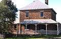 Home made of sandstock bricks
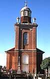 St Matthew's Anglican Church, designed by Francis Greenway
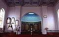 St Matthew's, interior
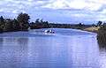 Hawkesbury River at Windsor
See also
References
- 1 2 Australian Bureau of Statistics (27 June 2017). "Windsor (State Suburb)". 2016 Census QuickStats. Retrieved 14 October 2018.

- ↑ Baker, Helen (1967). Historic Buildings. Windsor and Richmond (1st ed.). The State Planning Authority of New South Wales.
- ↑ "Reports of a possible French invasion off the Hawksbury". Hawkesbury Historical Society. Archived from the original on 19 March 2012. Retrieved 18 December 2016.
- ↑ "Windsor Railway Station Group and Former Goods Yard, New South Wales State Heritage Register (NSW SHR) Number H01287". New South Wales State Heritage Register. Office of Environment and Heritage. Retrieved 18 May 2018.
- ↑ "Stables at rear of Police Station, New South Wales State Heritage Register (NSW SHR) Number H01018". New South Wales State Heritage Register. Office of Environment and Heritage. Retrieved 18 May 2018.
- ↑ "Claremont Cottage, New South Wales State Heritage Register (NSW SHR) Number H00738". New South Wales State Heritage Register. Office of Environment and Heritage. Retrieved 18 May 2018.
- ↑ "Windsor Court House, New South Wales State Heritage Register (NSW SHR) Number H00804". New South Wales State Heritage Register. Office of Environment and Heritage. Retrieved 18 May 2018.
- ↑ "Mackenzie House, New South Wales State Heritage Register (NSW SHR) Number H00735". New South Wales State Heritage Register. Office of Environment and Heritage. Retrieved 18 May 2018.
- ↑ "Government Cottage Archaeological Site, New South Wales State Heritage Register (NSW SHR) Number H01843". New South Wales State Heritage Register. Office of Environment and Heritage. Retrieved 18 May 2018.
- ↑ "Loder House, New South Wales State Heritage Register (NSW SHR) Number H00003". New South Wales State Heritage Register. Office of Environment and Heritage. Retrieved 18 May 2018.
- ↑ "Simmons Hardware Store, New South Wales State Heritage Register (NSW SHR) Number H00667". New South Wales State Heritage Register. Office of Environment and Heritage. Retrieved 18 May 2018.
- ↑ "Rev. Peter Turner Cottage and Well, New South Wales State Heritage Register (NSW SHR) Number H00202". New South Wales State Heritage Register. Office of Environment and Heritage. Retrieved 18 May 2018.
- ↑ "McQuade Park, New South Wales State Heritage Register (NSW SHR) Number H01851". New South Wales State Heritage Register. Office of Environment and Heritage. Retrieved 18 May 2018.
- ↑ "Terrace Building, New South Wales State Heritage Register (NSW SHR) Number H00075". New South Wales State Heritage Register. Office of Environment and Heritage. Retrieved 18 May 2018.
- ↑ "Uniting Church and Hall, New South Wales State Heritage Register (NSW SHR) Number H00735". New South Wales State Heritage Register. Office of Environment and Heritage. Retrieved 18 May 2018.
- ↑ "Methodist Parsonage (former), New South Wales State Heritage Register (NSW SHR) Number H00735". New South Wales State Heritage Register. Office of Environment and Heritage. Retrieved 18 May 2018.
- ↑ "St. Matthew's Anglican Church, Rectory, Stables & Cemetery, New South Wales State Heritage Register (NSW SHR) Number H00015". New South Wales State Heritage Register. Office of Environment and Heritage. Retrieved 18 May 2018.
- ↑ "House, New South Wales State Heritage Register (NSW SHR) Number H00150". New South Wales State Heritage Register. Office of Environment and Heritage. Retrieved 18 May 2018.
- ↑ "House, New South Wales State Heritage Register (NSW SHR) Number H00108". New South Wales State Heritage Register. Office of Environment and Heritage. Retrieved 18 May 2018.
- ↑ "Cottage, New South Wales State Heritage Register (NSW SHR) Number H00107". New South Wales State Heritage Register. Office of Environment and Heritage. Retrieved 18 May 2018.
- ↑ "House, New South Wales State Heritage Register (NSW SHR) Number H00142". New South Wales State Heritage Register. Office of Environment and Heritage. Retrieved 18 May 2018.
- ↑ "House, New South Wales State Heritage Register (NSW SHR) Number H00109". New South Wales State Heritage Register. Office of Environment and Heritage. Retrieved 18 May 2018.
- ↑ "Houses, New South Wales State Heritage Register (NSW SHR) Number H00110". New South Wales State Heritage Register. Office of Environment and Heritage. Retrieved 18 May 2018.
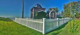
- ↑ "Peninsula House, Tebbutt's Observatory, New South Wales State Heritage Register (NSW SHR) Number H00028". New South Wales State Heritage Register. Office of Environment and Heritage. Retrieved 18 May 2018.
- ↑ "Macquarie Arms Hotel, New South Wales State Heritage Register (NSW SHR) Number H00041". New South Wales State Heritage Register. Office of Environment and Heritage. Retrieved 18 May 2018.
- ↑ "Thompson Square Conservation Area, New South Wales State Heritage Register (NSW SHR) Number H00126". New South Wales State Heritage Register. Office of Environment and Heritage. Retrieved 18 May 2018.
- ↑ "House & Outbuildings, New South Wales State Heritage Register (NSW SHR) Number H00005". New South Wales State Heritage Register. Office of Environment and Heritage. Retrieved 18 May 2018.
- ↑ ABS. "National Regional Profile: Windsor (People/Population)". Australian Bureau of Statistics. Retrieved 6 December 2016.
- ↑ ABS. "National Regional Profile: Windsor (Economy)". Australian Bureau of Statistics. Retrieved 6 December 2016.
- ↑ REALESTATE.COM.AU. "Suburb Profile: Windsor". Realestate.com.au. REA Group LTD. Retrieved 6 December 2016.
- ↑ Station Names. Date of opening, closing and/or change of name. Public Transport Commission of New South Wales. Administrative Branch (Archives Section) (3rd ed.). February 1979 [1965]. p. 37.
- ↑ Liz Foschia (4 Dec 2013). "NSW Premier's office accused of political interference in Windsor Bridge approval". ABC News. Australia. Retrieved 15 January 2015.
- ↑ CAWB. "An Alternative - CAWB". Community Action for Windsor Bridge. Retrieved 6 December 2016.
- ↑ 83 Macquarie St, Parramatta NSW 2150 to 98 Macquarie St, Windsor NSW 2756 (Map). Google Maps. Retrieved 18 December 2016.
External links
| Wikimedia Commons has media related to Windsor, New South Wales. |