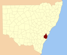
Camden County, New South Wales

Camden
New South Wales
Location in New South Wales
Lands administrative divisions around Camden:
Westmoreland Cook Cumberland
Argyle Camden Pacific Ocean
Argyle St Vincent Pacific Ocean

Camden County was one of the original Nineteen Counties in New South Wales and is now one of the 141 Cadastral divisions of New South Wales. It included the coastal area near Wollongong south to the Shoalhaven River, and also inland encompassing Berrima and Picton. Its western boundary was the Wollondilly River. The first settlement in the area was Camden Park, established by John Macarthur in 1806, just across the Nepean River from Cumberland County. It was the first land across the Nepean to be settled. Camden is a present-day suburb of Sydney in the same area, although parts of it are in Cumberland.

Camden County is named in honour of John Pratt, 1st Marquess Camden (1759–1840).[1] The Electoral district of Western Division of Camden was one of the first electoral districts for the area, between 1856 and 1859.

In 1852 it had an area of 1,403,320 acres (5,679.0 km2) and population of 9,663.[2]

Parishes within this county

A full list of parishes found within this county; their current LGA and mapping coordinates to the approximate centre of each location is as follows:

ParishLGACoordinates
BangadillyWingecarribee Shire34°22′54″S 150°09′04″E / 34.38167°S 150.15111°E / -34.38167; 150.15111 (Bangadilly Parish)
BanksiaWingecarribee Shire34°18′54″S 150°39′04″E / 34.31500°S 150.65111°E / -34.31500; 150.65111 (Banksia Parish)
BargoWollondilly Shire34°17′54″S 150°36′04″E / 34.29833°S 150.60111°E / -34.29833; 150.60111 (Bargo Parish)
BelangloWingecarribee Shire34°30′54″S 150°15′04″E / 34.51500°S 150.25111°E / -34.51500; 150.25111 (Belanglo Parish)
BerrimaWingecarribee ShireParish 34°25′54″S 150°20′04″E / 34.43167°S 150.33444°E / -34.43167; 150.33444
Bong BongWingecarribee Shire34°31′54″S 150°21′04″E / 34.53167°S 150.35111°E / -34.53167; 150.35111 (Bong Bong Parish)
BroughtonCity of Shoalhaven34°43′54″S 150°42′04″E / 34.73167°S 150.70111°E / -34.73167; 150.70111 (Broughton Parish)
BugongCity of Shoalhaven34°46′54″S 150°28′04″E / 34.78167°S 150.46778°E / -34.78167; 150.46778 (Bugong Parish)
BullioWingecarribee Shire34°19′54″S 150°08′04″E / 34.33167°S 150.13444°E / -34.33167; 150.13444 (Bullio Parish)
BumballaGoulburn Mulwaree Council34°42′54″S 150°06′04″E / 34.71500°S 150.10111°E / -34.71500; 150.10111 (Bumballa Parish)
BunberraCity of Shoalhaven34°48′54″S 150°37′04″E / 34.81500°S 150.61778°E / -34.81500; 150.61778 (Bunberra Parish)
BundanoonWingecarribee Shire34°40′54″S 150°15′04″E / 34.68167°S 150.25111°E / -34.68167; 150.25111 (Bundanoon Parish)
BurkeWingecarribee Shire34°27′54″S 150°35′04″E / 34.46500°S 150.58444°E / -34.46500; 150.58444 (Burke Parish)
BurragorangWollondilly Shire34°05′54″S 150°30′04″E / 34.09833°S 150.50111°E / -34.09833; 150.50111 (Burragorang Parish)
BurrawangWingecarribee Shire34°43′54″S 150°24′04″E / 34.73167°S 150.40111°E / -34.73167; 150.40111 (Burrawang Parish)
CalderwoodCity of Wollongong34°32′54″S 150°45′04″E / 34.54833°S 150.75111°E / -34.54833; 150.75111 (Calderwood Parish)
CambewarraCity of Shoalhaven34°44′54″S 150°34′04″E / 34.74833°S 150.56778°E / -34.74833; 150.56778 (Cambewarra Parish)
CamdenCamden Council34°04′54″S 150°40′04″E / 34.08167°S 150.66778°E / -34.08167; 150.66778 (Camden Parish)
CaouraGoulburn Mulwaree Council34°45′54″S 150°15′04″E / 34.76500°S 150.25111°E / -34.76500; 150.25111 (Caoura Parish)
ColoWingecarribee Shire34°22′54″S 150°32′04″E / 34.38167°S 150.53444°E / -34.38167; 150.53444 (Colo Parish)
CoolangattaCity of Shoalhaven34°48′54″S 150°42′04″E / 34.81500°S 150.70111°E / -34.81500; 150.70111 (Coolangatta Parish)
CordeauxCity of Wollongong34°19′54″S 150°48′04″E / 34.33167°S 150.80111°E / -34.33167; 150.80111 (Cordeaux Parish)
CouridjahWollondilly Shire34°10′54″S 150°30′04″E / 34.18167°S 150.50111°E / -34.18167; 150.50111 (Couridjah Parish)
CumbertineWingecarribee Shire34°14′54″S 150°23′04″E / 34.24833°S 150.38444°E / -34.24833; 150.38444 (Cumbertine Parish)
DendrobiumCity of Wollongong34°20′54″S 150°43′04″E / 34.34833°S 150.71778°E / -34.34833; 150.71778 (Dendrobium Parish)
IllarooCity of Shoalhaven34°52′54″S 150°29′04″E / 34.88167°S 150.48444°E / -34.88167; 150.48444 (Illaroo Parish)
JamberooMunicipality of Kiama34°36′54″S 150°47′04″E / 34.61500°S 150.78444°E / -34.61500; 150.78444 (Jamberoo Parish)
JelloreWingecarribee Shire34°19′54″S 150°20′04″E / 34.33167°S 150.33444°E / -34.33167; 150.33444 (Jellore Parish)
JoadjaWingecarribee Shire34°20′54″S 150°17′04″E / 34.34833°S 150.28444°E / -34.34833; 150.28444 (Joadja Parish)
KangaloonWingecarribee Shire34°32′54″S 150°36′04″E / 34.54833°S 150.60111°E / -34.54833; 150.60111 (Kangaloon Parish)
KemblaCity of Wollongong34°26′54″S 150°47′04″E / 34.44833°S 150.78444°E / -34.44833; 150.78444 (Kembla Parish)
KiamaMunicipality of Kiama34°39′54″S 150°46′04″E / 34.66500°S 150.76778°E / -34.66500; 150.76778 (Kiama Parish)
KillawarrahWollondilly Shire34°11′54″S 150°26′04″E / 34.19833°S 150.43444°E / -34.19833; 150.43444 (Killawarrah Parish)
MerylaWingecarribee Shire34°44′54″S 150°20′04″E / 34.74833°S 150.33444°E / -34.74833; 150.33444 (Meryla Parish)
MittagongWingecarribee Shire34°29′54″S 150°30′04″E / 34.49833°S 150.50111°E / -34.49833; 150.50111 (ittagong Parish)
MoollattooCity of Shoalhaven34°47′54″S 150°23′04″E / 34.79833°S 150.38444°E / -34.79833; 150.38444 (Moollattoo Parish)
MurrimbaWingecarribee Shire34°36′54″S 150°09′04″E / 34.61500°S 150.15111°E / -34.61500; 150.15111 (Murrimba Parish)
NattaiWollondilly Shire34°09′54″S 150°21′04″E / 34.16500°S 150.35111°E / -34.16500; 150.35111 (Nattai Parish)
NundiallaWingecarribee Shire34°31′54″S 150°08′04″E / 34.53167°S 150.13444°E / -34.53167; 150.13444 (Nundialla Parish)
PictonWollondilly Shire34°06′54″S 150°35′04″E / 34.11500°S 150.58444°E / -34.11500; 150.58444 (Picton Parish)
Sutton ForestWingecarribee Shire34°36′54″S 150°15′04″E / 34.61500°S 150.25111°E / -34.61500; 150.25111 (Sutton Forest Parish)
TerragongShellharbour City Council34°35′54″S 150°50′04″E / 34.59833°S 150.83444°E / -34.59833; 150.83444 (Terragong Parish)
WallandoolaCity of Wollongong34°16′54″S 150°45′04″E / 34.28167°S 150.75111°E / -34.28167; 150.75111 (Wallandoola Parish)
WallayaCity of Shoalhaven34°40′54″S 150°40′04″E / 34.68167°S 150.66778°E / -34.68167; 150.66778 (Wallaya Parish)
WanganderryWingecarribee Shire34°13′54″S 150°18′04″E / 34.23167°S 150.30111°E / -34.23167; 150.30111 (Wanganderry Parish)
WarragambaWollondilly Shire33°55′54″S 150°36′04″E / 33.93167°S 150.60111°E / -33.93167; 150.60111 (Warragamba Parish)
WerombaWollondilly Shire33°58′54″S 150°35′04″E / 33.98167°S 150.58444°E / -33.98167; 150.58444 (Weromba Parish)
WerriberriWollondilly Shire33°59′54″S 150°30′04″E / 33.99833°S 150.50111°E / -33.99833; 150.50111 (Werriberri Parish)
WiltonWollondilly Shire34°15′54″S 150°42′04″E / 34.26500°S 150.70111°E / -34.26500; 150.70111 (Wilton Parish)
WingelloWingecarribee Shire34°40′54″S 150°08′04″E / 34.68167°S 150.13444°E / -34.68167; 150.13444 (Wingello Parish)
WollongongCity of Wollongong34°30′54″S 150°51′04″E / 34.51500°S 150.85111°E / -34.51500; 150.85111 (Wollongong Parish)
WongawilliWingecarribee Shire34°29′54″S 150°40′04″E / 34.49833°S 150.66778°E / -34.49833; 150.66778 (Wongawilli Parish)
WoononaCity of Wollongong34°19′54″S 150°52′04″E / 34.33167°S 150.86778°E / -34.33167; 150.86778 (Woonona Parish)
YarrawaWingecarribee Shire34°39′54″S 150°34′04″E / 34.66500°S 150.56778°E / -34.66500; 150.56778 (Yarrawa Parish)
YarrungaWingecarribee Shire34°37′54″S 150°27′04″E / 34.63167°S 150.45111°E / -34.63167; 150.45111 (Yarrunga Parish)
YarrungaCity of Shoalhaven34°35′54″S 150°28′04″E / 34.59833°S 150.46778°E / -34.59833; 150.46778 (Yarrunga Parish)

References

  1. "Camden County". Geographical Names Register (GNR) of NSW. Geographical Names Board of New South Wales.
  2. "Old Welsh Books with English Translations", The Land of Gold: the Companion for the Welsh Emigrant to Australia, 1852
This article is issued from Wikipedia. The text is licensed under Creative Commons - Attribution - Sharealike. Additional terms may apply for the media files.