Rous County

Rous
New South Wales
Location in New South Wales
Lands administrative divisions around Rous:
Merivale (Qld) Ward (Qld) Pacific Ocean
Buller Rous Pacific Ocean
Drake Richmond Pacific Ocean

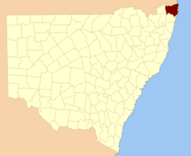
Rous County is one of the 141 Cadastral divisions of New South Wales. It is located at the north-east tip of the state. It is bordered on the north by the border with Queensland and on the south by the Richmond River. It contains Lismore, Byron Bay and Murwillumbah.

Rous County was named in honour of Admiral Henry John Rous (1795-1877).[1]

Parishes within this county

A full list of parishes found within this county; their current LGA and mapping coordinates to the approximate centre of each location is as follows:

ParishLGACoordinates
BabyilKyogle Shire28°37′54″S 152°45′04″E / 28.63167°S 152.75111°E / -28.63167; 152.75111 (Babyil Parish)
BallinaBallina Shire28°49′54″S 153°33′04″E / 28.83167°S 153.55111°E / -28.83167; 153.55111 (Ballina Parish)
BerwickTweed Shire28°13′54″S 153°25′04″E / 28.23167°S 153.41778°E / -28.23167; 153.41778 (Berwick Parish)
BexhillCity of Lismore28°45′54″S 153°22′04″E / 28.76500°S 153.36778°E / -28.76500; 153.36778 (Bexhill Parish)
BillinudgelTweed Shire28°30′54″S 153°30′04″E / 28.51500°S 153.50111°E / -28.51500; 153.50111 (Billinudgel Parish)
BingalBallina Shire28°56′54″S 153°28′04″E / 28.94833°S 153.46778°E / -28.94833; 153.46778 (Bingal Parish)
BlakebrookCity of Lismore28°45′54″S 153°16′04″E / 28.76500°S 153.26778°E / -28.76500; 153.26778 (Blakebrook Parish)
BoorabeeCity of Lismore28°39′54″S 153°05′04″E / 28.66500°S 153.08444°E / -28.66500; 153.08444 (Boorabee Parish)
BroadwaterCity of Lismore29°00′54″S 153°24′04″E / 29.01500°S 153.40111°E / -29.01500; 153.40111 (Broadwater Parish)
BrunswickByron Shire28°35′54″S 153°31′04″E / 28.59833°S 153.51778°E / -28.59833; 153.51778 (Brunswick Parish)
BungabbeeCity of Lismore28°43′54″S 153°08′04″E / 28.73167°S 153.13444°E / -28.73167; 153.13444 (Bungabbee Parish)
BurrellKyogle Shire28°23′54″S 153°15′04″E / 28.39833°S 153.25111°E / -28.39833; 153.25111 (Burrell Parish)
ByronByron Shire28°39′54″S 153°32′04″E / 28.66500°S 153.53444°E / -28.66500; 153.53444 (Byron Parish)
ChillinghamKyogle Shire28°16′54″S 153°13′04″E / 28.28167°S 153.21778°E / -28.28167; 153.21778 (Chillingham Parish)
ClunesCity of Lismore28°40′54″S 153°25′04″E / 28.68167°S 153.41778°E / -28.68167; 153.41778 (Clunes Parish)
CondongTweed Shire28°19′54″S 153°27′04″E / 28.33167°S 153.45111°E / -28.33167; 153.45111 (Condong Parish)
CorakiCity of Lismore29°00′54″S 153°19′04″E / 29.01500°S 153.31778°E / -29.01500; 153.31778 (Coraki Parish)
CougalKyogle Shire28°22′54″S 152°57′04″E / 28.38167°S 152.95111°E / -28.38167; 152.95111 (Cougal Parish)
CudgenTweed Shire28°16′54″S 153°33′04″E / 28.28167°S 153.55111°E / -28.28167; 153.55111 (Cudgen Parish)
DunbibleTweed Shire28°22′54″S 153°23′04″E / 28.38167°S 153.38444°E / -28.38167; 153.38444 (Dunbible Parish)
DunoonCity of Lismore28°39′54″S 153°19′04″E / 28.66500°S 153.31778°E / -28.66500; 153.31778 (Dunoon Parish)
DyraabaKyogle Shire28°47′54″S 152°47′04″E / 28.79833°S 152.78444°E / -28.79833; 152.78444 (Dyraaba Parish)
East GundurimbaCity of Lismore28°51′54″S 153°18′04″E / 28.86500°S 153.30111°E / -28.86500; 153.30111 (East Gundurimba Parish)
EttrickKyogle Shire28°34′54″S 152°52′04″E / 28.58167°S 152.86778°E / -28.58167; 152.86778 (Ettrick Parish)
Fairy MountKyogle Shire28°33′54″S 153°03′04″E / 28.56500°S 153.05111°E / -28.56500; 153.05111 (Fairy Mount Parish)
FindonKyogle Shire28°22′54″S 152°51′04″E / 28.38167°S 152.85111°E / -28.38167; 152.85111 (Findon Parish)
GenevaKyogle Shire28°36′54″S 152°57′04″E / 28.61500°S 152.95111°E / -28.61500; 152.95111 (Geneva Parish)
GooninbarKyogle Shire28°29′54″S 153°16′04″E / 28.49833°S 153.26778°E / -28.49833; 153.26778 (Gooninbar Parish)
Hanging RockCity of Lismore28°31′54″S 153°08′04″E / 28.53167°S 153.13444°E / -28.53167; 153.13444 (Hanging Rock Parish)
JasperByron Shire28°36′54″S 153°26′04″E / 28.61500°S 153.43444°E / -28.61500; 153.43444 (Jasper Parish)
JiggiCity of Lismore28°36′54″S 153°08′04″E / 28.61500°S 153.13444°E / -28.61500; 153.13444 (Jiggi Parish)
KunghurTweed Shire28°27′54″S 153°12′04″E / 28.46500°S 153.20111°E / -28.46500; 153.20111 (Kunghur Parish)
KynnumboonTweed Shire28°16′54″S 153°20′04″E / 28.28167°S 153.33444°E / -28.28167; 153.33444 (Kynnumboon Parish)
Kyogle ShireRichmond Valley Council28°45′54″S 153°00′04″E / 28.76500°S 153.00111°E / -28.76500; 153.00111 (Kyogle Shire Parish)
LangwellKyogle Shire28°38′54″S 152°51′04″E / 28.64833°S 152.85111°E / -28.64833; 152.85111 (Langwell Parish)
LismoreCity of Lismore28°49′54″S 153°23′04″E / 28.83167°S 153.38444°E / -28.83167; 153.38444 (Lismore Parish)
LoadstoneKyogle Shire28°25′54″S 152°57′04″E / 28.43167°S 152.95111°E / -28.43167; 152.95111 (Loadstone Parish)
MeerschaumBallina Shire28°53′54″S 153°24′04″E / 28.89833°S 153.40111°E / -28.89833; 153.40111 (Meerschaum Parish)
MooballTweed Shire28°24′54″S 153°29′04″E / 28.41500°S 153.48444°E / -28.41500; 153.48444 (Mooball Parish)
MullumbimbyByron Shire28°31′54″S 153°26′04″E / 28.53167°S 153.43444°E / -28.53167; 153.43444 (Mullumbimby Parish)
MummulgumKyogle Shire28°52′54″S 152°47′04″E / 28.88167°S 152.78444°E / -28.88167; 152.78444 (Mummulgum Parish)
MurwillumbahTweed Shire28°19′54″S 153°17′04″E / 28.33167°S 153.28444°E / -28.33167; 153.28444 (Murwillumbah Parish)
NewrybarBallina Shire28°44′54″S 153°33′04″E / 28.74833°S 153.55111°E / -28.74833; 153.55111 (Newrybar Parish)
NimbinCity of Lismore28°37′54″S 153°14′04″E / 28.63167°S 153.23444°E / -28.63167; 153.23444 (Nimbin Parish)
North CasinoRichmond Valley Council28°46′54″S 153°04′04″E / 28.78167°S 153.06778°E / -28.78167; 153.06778 (North Casino Parish)
North CodringtonCity of Lismore28°55′54″S 153°15′04″E / 28.93167°S 153.25111°E / -28.93167; 153.25111 (North Codrington Parish)
North LismoreCity of Lismore28°44′54″S 153°18′04″E / 28.74833°S 153.30111°E / -28.74833; 153.30111 (North Lismore Parish)
NullumTweed Shire28°26′54″S 153°22′04″E / 28.44833°S 153.36778°E / -28.44833; 153.36778 (Nullum Parish)
PimlicoBallina Shire28°53′54″S 153°30′04″E / 28.89833°S 153.50111°E / -28.89833; 153.50111 (Pimlico Parish)
QueebunKyogle Shire28°44′54″S 152°51′04″E / 28.74833°S 152.85111°E / -28.74833; 152.85111 (Queebun Parish)
RoseberryKyogle Shire28°29′54″S 152°52′04″E / 28.49833°S 152.86778°E / -28.49833; 152.86778 (Roseberry Parish)
RunnymedeKyogle Shire28°39′54″S 153°02′04″E / 28.66500°S 153.03444°E / -28.66500; 153.03444 (Runnymede Parish)
RunnymedeKyogle Shire28°40′54″S 153°00′04″E / 28.68167°S 153.00111°E / -28.68167; 153.00111 (Runnymede Parish)
SherwoodKyogle Shire28°28′54″S 152°46′04″E / 28.48167°S 152.76778°E / -28.48167; 152.76778 (Sherwood Parish)
South GundurimbaCity of Lismore28°51′54″S 153°13′04″E / 28.86500°S 153.21778°E / -28.86500; 153.21778 (South Gundurimba Parish)
South LismoreCity of Lismore28°48′54″S 153°15′04″E / 28.81500°S 153.25111°E / -28.81500; 153.25111 (South Lismore Parish)
StrathedenKyogle Shire28°44′54″S 152°57′04″E / 28.74833°S 152.95111°E / -28.74833; 152.95111 (Stratheden Parish)
TeraniaCity of Lismore28°33′54″S 153°15′04″E / 28.56500°S 153.25111°E / -28.56500; 153.25111 (Terania Parish)
TerranoraTweed Shire28°12′54″S 153°30′04″E / 28.21500°S 153.50111°E / -28.21500; 153.50111 (Terranora Parish)
TevenByron Shire28°45′54″S 153°32′04″E / 28.76500°S 153.53444°E / -28.76500; 153.53444 (Teven Parish)
TomkiRichmond Valley Council28°49′54″S 153°08′04″E / 28.83167°S 153.13444°E / -28.83167; 153.13444 (Tomki Parish)
ToolondTweed Shire28°31′54″S 153°21′04″E / 28.53167°S 153.35111°E / -28.53167; 153.35111 (Toolond Parish)
ToonumbarKyogle Shire28°32′54″S 152°46′04″E / 28.54833°S 152.76778°E / -28.54833; 152.76778 (Toonumbar Parish)
TuckombilBallina Shire28°49′54″S 153°28′04″E / 28.83167°S 153.46778°E / -28.83167; 153.46778 (Tuckombil Parish)
TuckurimbaCity of Lismore28°55′54″S 153°19′04″E / 28.93167°S 153.31778°E / -28.93167; 153.31778 (Tuckurimba Parish)
TunstallCity of Lismore28°41′54″S 153°14′04″E / 28.69833°S 153.23444°E / -28.69833; 153.23444 (Tunstall Parish)
TyalgumTweed Shire28°22′54″S 153°09′04″E / 28.38167°S 153.15111°E / -28.38167; 153.15111 (Tyalgum Parish)
TygalgahTweed Shire28°18′54″S 153°25′04″E / 28.31500°S 153.41778°E / -28.31500; 153.41778 (Tygalgah Parish)
UnumgarKyogle Shire28°22′54″S 152°45′04″E / 28.38167°S 152.75111°E / -28.38167; 152.75111 (Unumgar Parish)
WarrazambilKyogle Shire28°29′54″S 153°04′04″E / 28.49833°S 153.06778°E / -28.49833; 153.06778 (Warrazambil Parish)
Whian WhianCity of Lismore28°35′54″S 153°20′04″E / 28.59833°S 153.33444°E / -28.59833; 153.33444 (Whian Whian Parish)
WiangareeKyogle Shire28°33′54″S 153°00′04″E / 28.56500°S 153.00111°E / -28.56500; 153.00111 (Wiangaree Parish)
WollumbinTweed Shire28°22′54″S 153°19′04″E / 28.38167°S 153.31778°E / -28.38167; 153.31778 (Wollumbin Parish)
WorendoKyogle Shire28°22′54″S 153°04′04″E / 28.38167°S 153.06778°E / -28.38167; 153.06778 (Worendo Parish)
WyndhamKyogle Shire28°30′54″S 152°56′04″E / 28.51500°S 152.93444°E / -28.51500; 152.93444 (Wyndham Parish)

References

  1. "Rous". Geographical Names Register (GNR) of NSW. Geographical Names Board of New South Wales. Retrieved 3 August 2013.
This article is issued from Wikipedia. The text is licensed under Creative Commons - Attribution - Sharealike. Additional terms may apply for the media files.