Parish of Appin
| Appin New South Wales | |||||||||||||||
|---|---|---|---|---|---|---|---|---|---|---|---|---|---|---|---|
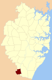 Location of the parish within Cumberland | |||||||||||||||
| Established | 1835 | ||||||||||||||
| LGA(s) | Wollondilly Shire | ||||||||||||||
| County | Cumberland | ||||||||||||||
| Hundred (former) | Campbelltown | ||||||||||||||
| |||||||||||||||
Appin Parish, Cumberland is one of the 57 parishes of Cumberland County, New South Wales, a cadastral unit for use on land titles.[1] Its eastern boundary is the Georges River, and western boundary the Nepean River and Cataract River. It is centred on Appin.
References
- ↑ "Appin Parish". Geographical Names Register (GNR) of NSW. Geographical Names Board of New South Wales. Retrieved 1 August 2013.
This article is issued from
Wikipedia.
The text is licensed under Creative Commons - Attribution - Sharealike.
Additional terms may apply for the media files.