Hunter County

Hunter
New South Wales
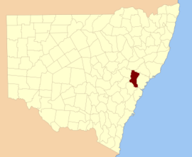
Location in New South Wales
Lands administrative divisions around Hunter:
Phillip Brisbane Durham
Phillip Hunter Northumberland
Roxburgh Cook Cumberland

Hunter County was one of the original Nineteen Counties in New South Wales and is now one of the 141 Cadastral divisions of New South Wales. It lies between the Hunter River in the north, and the Colo River in the south, including much of Wollemi National Park. Macdonald River lies to the east.

Hunter County was named in honour of Governor John Hunter (1737-1821).[1]

Parishes within this county

A full list of parishes found within this county; their current LGA and mapping coordinates to the approximate centre of each location is as follows:

ParishLGACoordinates
AngorawaCity of Hawkesbury33°18′54″S 150°44′04″E / 33.31500°S 150.73444°E / -33.31500; 150.73444 (Angorawa Parish)
ArndellMuswellbrook Shire32°21′54″S 150°34′04″E / 32.36500°S 150.56778°E / -32.36500; 150.56778 (Arndell Parish)
BaeramiMuswellbrook Shire32°24′54″S 150°27′04″E / 32.41500°S 150.45111°E / -32.41500; 150.45111 (Baerami Parish)
BlackwaterMuswellbrook Shire32°40′54″S 150°24′04″E / 32.68167°S 150.40111°E / -32.68167; 150.40111 (Blackwater Parish)
BulgaSingleton Council32°49′54″S 150°49′04″E / 32.83167°S 150.81778°E / -32.83167; 150.81778 (Bulga Parish)
BureenMuswellbrook Shire32°28′54″S 150°39′04″E / 32.48167°S 150.65111°E / -32.48167; 150.65111 (Bureen Parish)
CaperteeCity of Lithgow33°05′54″S 150°23′04″E / 33.09833°S 150.38444°E / -33.09833; 150.38444 (Capertee Parish)
CarooraMuswellbrook Shire32°33′54″S 150°25′04″E / 32.56500°S 150.41778°E / -32.56500; 150.41778 (Caroora Parish)
ColoCity of Hawkesbury33°23′24″S 150°47′04″E / 33.39000°S 150.78444°E / -33.39000; 150.78444 (Colo Parish)
CookCity of Hawkesbury33°15′54″S 150°35′04″E / 33.26500°S 150.58444°E / -33.26500; 150.58444 (Cook Parish)
CoonbaralbaSingleton Council32°36′54″S 150°53′04″E / 32.61500°S 150.88444°E / -32.61500; 150.88444 (Coonbaralba Parish)
CoorongoobaCity of Lithgow32°57′54″S 150°18′04″E / 32.96500°S 150.30111°E / -32.96500; 150.30111 (Coorongooba Parish)
CoricudgyMuswellbrook Shire32°52′54″S 150°25′04″E / 32.88167°S 150.41778°E / -32.88167; 150.41778 (Coricudgy Parish)
DoyleSingleton Council32°35′54″S 150°48′04″E / 32.59833°S 150.80111°E / -32.59833; 150.80111 (Doyle Parish)
Glen AliceCity of Lithgow33°03′54″S 150°15′04″E / 33.06500°S 150.25111°E / -33.06500; 150.25111 (Glen Alice Parish)
GronoCity of Hawkesbury33°18′54″S 150°49′04″E / 33.31500°S 150.81778°E / -33.31500; 150.81778 (Grono Parish)
GullongulongSingleton Council32°53′54″S 150°41′04″E / 32.89833°S 150.68444°E / -32.89833; 150.68444 (Gullongulong Parish)
GungalwaMuswellbrook Shire32°32′54″S 150°39′04″E / 32.54833°S 150.65111°E / -32.54833; 150.65111 (Gungalwa Parish)
HawkesburyCity of Hawkesbury33°24′24″S 150°52′04″E / 33.40667°S 150.86778°E / -33.40667; 150.86778 (Hawkesbury Parish)
HungerfordMuswellbrook Shire32°36′54″S 150°32′04″E / 32.61500°S 150.53444°E / -32.61500; 150.53444 (Hungerford Parish)
HunterMuswellbrook Shire32°28′54″S 150°45′04″E / 32.48167°S 150.75111°E / -32.48167; 150.75111 (Hunter Parish)
InnesCity of Lithgow33°04′54″S 150°29′04″E / 33.08167°S 150.48444°E / -33.08167; 150.48444 (Innes Parish)
IvoryCity of Hawkesbury33°09′54″S 150°45′04″E / 33.16500°S 150.75111°E / -33.16500; 150.75111 (Ivory Parish)
JamisonCity of Lithgow32°59′54″S 150°22′04″E / 32.99833°S 150.36778°E / -32.99833; 150.36778 (Jamison Parish)
KekeelbonSingleton Council32°48′54″S 150°32′04″E / 32.81500°S 150.53444°E / -32.81500; 150.53444 (Kekeelbon Parish)
KindarunSingleton Council32°49′54″S 150°42′04″E / 32.83167°S 150.70111°E / -32.83167; 150.70111 (Kindarun Parish)
LemingtonSingleton Council32°32′54″S 151°00′04″E / 32.54833°S 151.00111°E / -32.54833; 151.00111 (Lemington Parish)
MacdonaldCity of Hawkesbury33°17′54″S 150°56′04″E / 33.29833°S 150.93444°E / -33.29833; 150.93444 (Macdonald Parish)
MartindaleMuswellbrook Shire32°34′54″S 150°44′04″E / 32.58167°S 150.73444°E / -32.58167; 150.73444 (Martindale Parish)
McLeanSingleton Council32°58′54″S 150°24′04″E / 32.98167°S 150.40111°E / -32.98167; 150.40111 (Mclean Parish)
MedhurstSingleton Council32°45′54″S 150°37′04″E / 32.76500°S 150.61778°E / -32.76500; 150.61778 (Medhurst Parish)
MediwahMuswellbrook Shire32°27′54″S 150°32′04″E / 32.46500°S 150.53444°E / -32.46500; 150.53444 (Mediwah Parish)
MellongCity of Hawkesbury33°15′54″S 150°44′04″E / 33.26500°S 150.73444°E / -33.26500; 150.73444 (Mellong Parish)
MirrieMuswellbrook Shire32°36′54″S 150°24′04″E / 32.61500°S 150.40111°E / -32.61500; 150.40111 (Mirrie Parish)
MonundillaMuswellbrook Shire32°42′54″S 150°31′04″E / 32.71500°S 150.51778°E / -32.71500; 150.51778 (Monundilla Parish)
MyrtleSingleton Council32°50′54″S 150°36′04″E / 32.84833°S 150.60111°E / -32.84833; 150.60111 (Myrtle Parish)
NulloMuswellbrook Shire32°45′54″S 150°24′04″E / 32.76500°S 150.40111°E / -32.76500; 150.40111 (Nullo Parish)
PalomorangSingleton Council32°45′54″S 150°43′04″E / 32.76500°S 150.71778°E / -32.76500; 150.71778 (Palomorang Parish)
ParnellSingleton Council32°41′54″S 150°54′04″E / 32.69833°S 150.90111°E / -32.69833; 150.90111 (Parnell Parish)
ParrCity of Hawkesbury33°20′24″S 150°38′04″E / 33.34000°S 150.63444°E / -33.34000; 150.63444 (Parr Parish)
ParrySingleton Council32°59′54″S 150°30′04″E / 32.99833°S 150.50111°E / -32.99833; 150.50111 (Parry Parish)
PhillipSingleton Council32°45′54″S 150°29′04″E / 32.76500°S 150.48444°E / -32.76500; 150.48444 (Phillip Parish)
PiribilSingleton Council32°31′54″S 150°50′04″E / 32.53167°S 150.83444°E / -32.53167; 150.83444 (Piribil Parish)
PoppongSingleton Council32°44′54″S 150°51′04″E / 32.74833°S 150.85111°E / -32.74833; 150.85111 (Poppong Parish)
PuttySingleton Council32°58′54″S 150°45′04″E / 32.98167°S 150.75111°E / -32.98167; 150.75111 (Putty Parish)
Six BrothersCity of Hawkesbury33°11′54″S 150°37′04″E / 33.19833°S 150.61778°E / -33.19833; 150.61778 (Six Brothers Parish)
SturtSingleton Council32°52′54″S 150°30′04″E / 32.88167°S 150.50111°E / -32.88167; 150.50111 (Sturt Parish)
TollagongSingleton Council32°55′54″S 150°37′04″E / 32.93167°S 150.61778°E / -32.93167; 150.61778 (Tollagong Parish)
TomalpinMuswellbrook Shire32°32′54″S 150°33′04″E / 32.54833°S 150.55111°E / -32.54833; 150.55111 (Tomalpin Parish)
TongaSingleton Council32°40′54″S 150°45′04″E / 32.68167°S 150.75111°E / -32.68167; 150.75111 (Tonga Parish)
TupaSingleton Council33°00′54″S 150°37′04″E / 33.01500°S 150.61778°E / -33.01500; 150.61778 (Tupa Parish)
WamboSingleton Council32°31′54″S 150°55′04″E / 32.53167°S 150.91778°E / -32.53167; 150.91778 (Wambo Parish)
WarengSingleton Council32°50′54″S 150°47′04″E / 32.84833°S 150.78444°E / -32.84833; 150.78444 (Wareng Parish)
WeeneyCity of Hawkesbury33°03′54″S 150°46′04″E / 33.06500°S 150.76778°E / -33.06500; 150.76778 (Weeney Parish)
WhiteMuswellbrook Shire32°39′54″S 150°38′04″E / 32.66500°S 150.63444°E / -32.66500; 150.63444 (White Parish)
WhybrowSingleton Council32°37′54″S 151°00′04″E / 32.63167°S 151.00111°E / -32.63167; 151.00111 (Whybrow Parish)
WilpenMuswellbrook Shire32°28′54″S 150°26′04″E / 32.48167°S 150.43444°E / -32.48167; 150.43444 (Wilpen Parish)
WindsorCity of Hawkesbury33°10′54″S 150°49′04″E / 33.18167°S 150.81778°E / -33.18167; 150.81778 (Windsor Parish)
WirrabaCity of Hawkesbury33°06′54″S 150°33′04″E / 33.11500°S 150.55111°E / -33.11500; 150.55111 (Wirraba Parish)
WolganCity of Lithgow33°09′54″S 150°30′04″E / 33.16500°S 150.50111°E / -33.16500; 150.50111 (Wolgan Parish)
WollemiCity of Hawkesbury33°06′54″S 150°39′04″E / 33.11500°S 150.65111°E / -33.11500; 150.65111 (Wollemi Parish)
WomerahCity of Hawkesbury33°14′54″S 150°53′04″E / 33.24833°S 150.88444°E / -33.24833; 150.88444 (Womerah Parish)
WongaCity of Hawkesbury33°22′24″S 150°54′04″E / 33.37333°S 150.90111°E / -33.37333; 150.90111 (Wonga Parish)
YengoCity of Hawkesbury33°02′54″S 150°49′04″E / 33.04833°S 150.81778°E / -33.04833; 150.81778 (Yengo Parish)

References

  1. "Hunter County". Geographical Names Register (GNR) of NSW. Geographical Names Board of New South Wales.
This article is issued from Wikipedia. The text is licensed under Creative Commons - Attribution - Sharealike. Additional terms may apply for the media files.