Comilla
| Comilla কুমিল্লা Cumilla | |
|---|---|
| City | |
-01.jpg) .jpg) .jpg) .jpg)  .jpg) From top: Comilla Skyline, City Hall Library, Chondimura temple, Mainamati War Cemetery, Comilla Education Board, Mainamati | |
 Comilla | |
| Coordinates: 23°27′N 91°12′E / 23.450°N 91.200°ECoordinates: 23°27′N 91°12′E / 23.450°N 91.200°E | |
| Country | Bangladesh |
| Division | Chittagong Division |
| District | Comilla District |
| Municipality established | 1890 |
| City corporation | 10 July 2011 |
| Government | |
| • Type | Mayor–Council |
| • Body | Comilla City Corporation |
| • City Mayor | Monirul Haque Sakku |
| Area | |
| • Total | 153 km2 (59 sq mi) |
| Elevation | 72 m (236 ft) |
| Population (2018) | |
| • Total | 1,703,000 |
| • Density | 16,000/km2 (40,000/sq mi) |
| Demonym(s) | Comillian, Kumilli |
| Time zone | UTC+6 (BST) |
| Postal code | 3500–3583 |
| GDP (2017) | $10 billion |
| Calling code | 081 |
| Literacy percentage total | 57% |
| Website |
cocc |
Comilla, officially known as Cumilla,[1] is a city in the Chittagong Division of Bangladesh, located along the Dhaka-Chittagong Highway. It is the administrative centre of the Comilla District, part of the Chittagong Division. Comilla is the second-largest city of eastern Bangladesh after Chittagong and is one of the three oldest cities in Bangladesh.
History
Ancient era

The Comilla region was once under ancient Samatata and was joined with Tripura State. This district came under the reign of the kings of the Harikela in the ninth century AD. Lalmai Mainamati was ruled by the Deva dynasty (eighth century AD), and (during 10th and mid-11th century AD). In 1732, it became the centre of the Bengal-backed domain of Jagat Manikya.[2]
The Peasants’ Movement against the king of Tripura in 1764, which originally formed under the leadership of Shamsher Gazi is a notable historical event in Comilla.[3] It came under the rule of East India Company in 1765. This district was established as Tripura district in 1790. It was renamed Comilla in 1960. Chandpur and Brahmanbaria subdivisions of this district were transformed into districts in 1984.
British era
.jpg)
Communal tension spread over Comilla when a Muslim was shot in the town during the partition of Bengal in 1905. On 21 November 1921, Kazi Nazrul Islam composed patriotic songs and tried to awaken the town people by protesting the Prince of Wales's visit to India.[4] During this time, Avay Ashram, as a revolutionary institution, played a significant role. Poet Rabindranath Tagore and Mahatma Gandhi visited Comilla at that time. In 1931, approximately 4000 peasants in Mohini village in Chauddagram Upazila revolted against a land revenue tax. The British Gurkha soldiers fired indiscriminately on the crowd, killing four people.[5] In a major peasant gathering, the police fired at Hasnabad of Laksam Upazila in 1932. Two people were killed and many were wounded. Comilla Victoria Government College in the city was named in memory of Queen Victoria .
World War II
Comilla Cantonment is an important military base and the oldest in East Bengal. It was widely used by the British Indian Army during World War II. It was the headquarter of the British 14th Army. There is a war cemetery, Maynamati War Cemetery,[6] in Comilla that was established after the World War II to remember the Allied soldiers who died during World War I and II, mostly from Commonwealth states and the United States. There are a number of Japanese soldiers buried there as well, from the Second World War.
After Partition of Bengal
People of Comilla served as language fighters in 1952. Students of Comilla Victoria College protested against Pakistan Government. Shaheed Dhirendranath Datta was one of important leaders of the language movement who was from Comilla. Shib Narayan Das was one of designer of the first flag of Bangladesh. He was part of BLF. Comilla was part of sector 2 during the Liberation war of Bangladesh.
Geography
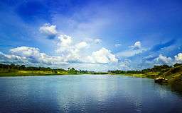
Comilla covers a total area of 51 square kilometres. It is bounded by Burchiganj and Tripura on the north, Laksham and Chauddagram on the south, and Barura on the west. The major rivers that pass through Comilla include Gumti[7] and Little Feni. The Tropic of Cancer crosses Comilla town on the south side just over the Tomsom Bridge.
Climate
Comilla has a tropical savanna climate. The Köppen-Geiger climate classification is Aw. The climate of Comilla is generally marked with monsoons, high temperature, considerable humidity and heavy rainfall. The hot season commences early in April and continues till July. The average annual temperature in Comilla is 25.5 °C (77.9 °F). About 2,295 mm (90.35 in) of precipitation falls annually.
| Climate data for Comilla | |||||||||||||
|---|---|---|---|---|---|---|---|---|---|---|---|---|---|
| Month | Jan | Feb | Mar | Apr | May | Jun | Jul | Aug | Sep | Oct | Nov | Dec | Year |
| Average high °C (°F) | 25.7 (78.3) |
28.1 (82.6) |
31.6 (88.9) |
32.8 (91) |
32.5 (90.5) |
31.2 (88.2) |
30.7 (87.3) |
31.0 (87.8) |
31.4 (88.5) |
31.0 (87.8) |
29.2 (84.6) |
26.5 (79.7) |
30.1 (86.3) |
| Average low °C (°F) | 12.4 (54.3) |
14.8 (58.6) |
19.6 (67.3) |
23.1 (73.6) |
24.4 (75.9) |
25.2 (77.4) |
25.3 (77.5) |
25.4 (77.7) |
25.3 (77.5) |
23.6 (74.5) |
18.8 (65.8) |
13.8 (56.8) |
21 (69.7) |
| Average precipitation mm (inches) | 9 (0.35) |
20 (0.79) |
49 (1.93) |
142 (5.59) |
259 (10.2) |
469 (18.46) |
457 (17.99) |
396 (15.59) |
265 (10.43) |
181 (7.13) |
45 (1.77) |
3 (0.12) |
2,295 (90.35) |
| Source: Climate-Data.org, Climate data | |||||||||||||
Points of interest
Comilla has a number of tourist attractions. Various archaeological relics discovered in the district, especially from the 7th–8th century, are now preserved in the Mainamati Museum.[8] There is a World War II war cemetery in Comilla, which is protected and maintained by the Commonwealth War Graves Commission.
- Points of interest
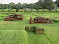 Shalban vihara
.jpg) World Peace Pagoda Analayo
World Peace Pagoda Analayo- Palace of Queen Mainamati
 Kotila Mura
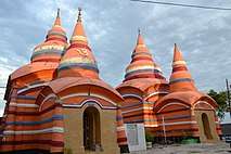 Chandi Mura
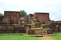 Itakhola Mura
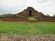 Rupban Mura
 Lotikot Mura
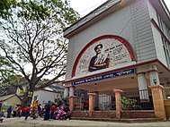 Kobi Nazrul Institute
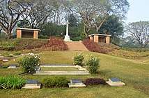 Mainamati War Cemetery
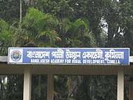 Bangladesh Academy for Rural Development Academy
.jpg) Gumti River
Gumti River.jpg) Gumti River
Gumti River.jpg) Comilla Zoo & Botanical Garden
Comilla Zoo & Botanical Garden.jpg) Dharmasagar Park
Dharmasagar Park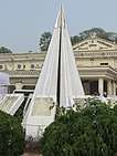 Comilla Town Hall
.jpg) Dharmasagar pond
Dharmasagar pond.jpg) Lalmai Hill
Lalmai Hill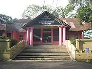 Ranir Kuthi
.jpg) Roop Sagar Park
Roop Sagar Park
Sports
Comilla Victorians is a professional cricket team based in Comilla and is the second most successful club in the Bangladesh Premier League.[9] Comilla Victorians also has the most wins in the league.[10]
Governance and politics
Politics
Comilla is one of the major cities for politics in the country. Bangladesh Nationalist Party and Bangladesh Awami League is popular throughout the city. Comilla runs for City Corporation elections also.
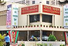
City Corporation[11] Comilla City Corporation is a self-governed municipal administration in Bangladesh that administers and oversees development and maintenance works in the city. The corporation covers an area of over 33 square kilometres in the Comilla district where over five million people live as permanent residents. The body was known as Comilla Municipality previously, until it obtained the City Corporation status by a ministry of local government declaration on 10 July 2011.[12]
The Comilla City Corporation is responsible for administering and providing basic infrastructure to the city.
- Water purification and supply
- Sewage treatment and disposal
- Garbage disposal and street cleanliness
- Solid waste management
- Building and maintenance of roads and streets.
- Street lighting
- Maintenance of parks and open spaces
- Cemeteries and Crematoriums
- Registering of births and deaths
- Conservation of heritage sites
- Disease control, including immunisation
- Public municipal schools etc.
Military
Comilla Cantonment is a cantonment located nearby the city. The personnel of Bangladesh Army with local civilian inhabit here.The 33rd Infantry Division HQ is also located here. Bangladesh Military Academy was initially established at Comilla Cantonment on 11 January 1974 and later relocated at Bhatiary in 1976. Comilla Cantonment provides Comilla Cadet College, Comilla Ispahani Public School and College, Comilla Cantonment College, Comilla Cantonment High School.
Administration
Comilla is controlled by the Comilla City Corporation. It has 27 wards.[12]
Metro neighbourhoods
These are the neighbourhoods of Comilla city.[13]
- Baghmara
- Bara Para
- Belghar
- Bholain (North)
- Bholain (South)
- Bijoypur
- Chapapur
- Chouara
- Galiara
- Purba Jorekaran
- Pachim Jorekaran
- Perul (North)
- Perul (South)
Transportation
Highway
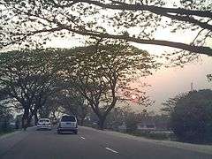
Comilla is a hub of road communication for the eastern part of Bangladesh. One of the oldest highways of the Indian Subcontinent, 'The Grand Trunk Road', passes through the city. The most important Dhaka–Chittagong Highway bypasses the city from the cantonment to Poduar Bazar.[14] Comilla is located 97 kilometres from the capital city, Dhaka, which can be reached by road or railway. Electric trikes in recent years have begun to overwhelm Comilla’s streets, mostly because of their convenience in short distance commutation throughout the main town.
Railway
Comilla is a nearby city of Laksham Junction and Akhaura Railway Junction (largest in the country). Rail connection is available to Dhaka, Chittagong, Brahmanbaria and Sylhet.
Air
Comilla's only airport is currently closed since the city is nearby other major cities. Comilla Airport was announced to open again in 2012. Its runway is 26 ft long.
Education
The Board of Secondary and Higher Secondary Education is responsible for holding public examinations (JSC, S.S.C and H.S.C) in Comilla and five nearby districts.
- Educational Institutions in Comilla
 The Comilla University is a public university located at Kotbari, Comilla, Bangladesh. It was established in 2006.
.jpg) Comilla Victoria Government College is one of the oldest & famous educational institute in Bangladesh. It was established in 1899.
Comilla Victoria Government College is one of the oldest & famous educational institute in Bangladesh. It was established in 1899.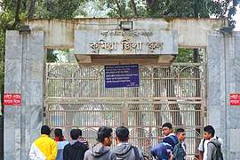 It is one of the oldest & prestigious school in the country. It was the only school in Comilla when it was established in 1837.
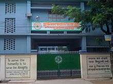 Comilla Modern High School is a combined school in Comilla city. It was established in 1993.
 Nawab Faizunnessa Government Girls' High School is a girls' school in Comilla. It was established in 1873 by Nabab Faizunnesa Choudhurani
.jpg) Comilla Cadet College (CCC) is a residential military high school in Comilla. It was established in 1983.
Comilla Cadet College (CCC) is a residential military high school in Comilla. It was established in 1983. The Board of Intermediate and Secondary Education, Comilla is an autonomous organization that is responsible for holding public examinations.
Notable residents
Shib Narayan Das was a member of BLF. He was one of the designers of the first flag of Bangladesh. Shaheed Dhirendranath Datta was ex-Minister of Law, Language movement activist and Shaheed of 1971. Many people like him fought for the country. Lt-Col. Akbar Hussain veteran freedom fighter. He was Minister of Mineral Sources in 1978. He was also Minister of Forest Preservation in 1991. Later he was Minister of Inland Water. Major Abdul Gani was born in Nagais village under Brahmmanpara upazilla of Comilla district on 1 December 1915. He, an officer of the armed forces division was the organiser of the First East Bengal Regiment. Khondaker Mostaq Ahmad was a President of Bangladesh; he also served as Minister and member of Exile Cabinet of Meherpur Government. Kazi Zafar Ahmed, was Prime Minister in 1988. He was also Minister of Education in 1986. Khandaker Mosharraf Hossain was Minister of Energy & Mineral Resources in 1991 and Minister of Health & Family Welfare in 2001.
Mustafa Kamal served as president of the International Cricket Council. Shaukat Mahmood was senior journalist and editor of Weekly Economic Times. He was elected president of National Press Club. Buddhadeb Bosu was a Bangla poet, novelist, translator, editor and essayist. Kazi Nazrul Islam was born in West Bengal, but resided at Comilla for long. He loved this place. Another poet was Abdul Kadir. Was also a researcher and editor. Lots of re-known high officials such secretary. Among them A K M Abdul Awal Mazumder is very honest, devoted to his works.
- Notable residents
 Mujibul Haque Mujib is a politician and member of the Jatiya Sangsad. Is Present Bangladeshi Rail Minister.
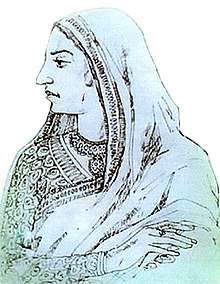 Nawab Begum Faizunnesa Choudhurani was Zamindar of Homnabad-Pashchimgaon Estate in present-day Comilla District. In 1889 Queen Victoria awarded Faizunnesa the title of "Nawab", making her the first female Nawab in South Asia.
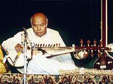 Ali Akbar Khan was a Hindustani classical musician of the Maihar gharana, known for his virtuosity in playing the sarod.
 Asif Akbar is a Bangladeshi pop singer. He releases solo, duet and mixed albums and also sings for Bangladeshi cinema.
 Shaukat Mahmood is a senior journalist, editor of Weekly Economic Times, adviser to Begum Khaleda Zia and elected president (2007–08, 2009-incumbent) of National Press Club
 Fazlul Halim Chowdhury was a fellow of the Bangladesh Academy of Sciences and one of the longest-serving Vice-Chancellors of the University of Dhaka.
 Aminul Islam was a Bangladeshi academic. He was the president of Bangladesh Academy of Sciences.
Sister cities
See also
References
- ↑ "Bangladesh changes English spellings of five districts". Bdnews24.com. Dhaka. 2 April 2018. Retrieved 2 April 2018.
- ↑ Kilikhar, Bidhas Kanti (1995). Tripura of the 18th Century with Samsher Gazi Against Feudalism: A Historical Study. Agartula: Chhapa Kathi, Tripura State Tribal Cultural Research Institute and Museum. p. 55.
- ↑ Nawaz, Ali (2012). "Shamsher Gazi". In Islam, Sirajul; Jamal, Ahmed A. Banglapedia: National Encyclopedia of Bangladesh (Second ed.). Asiatic Society of Bangladesh.
- ↑ Islam, Rafiqul (2012). "Islam, Kazi Nazrul". In Islam, Sirajul; Jamal, Ahmed A. Banglapedia: National Encyclopedia of Bangladesh (Second ed.). Asiatic Society of Bangladesh.
- ↑ Siddiqi, Mamun (2003). "Comilla District". In Islam, Sirajul; Jamal, Ahmed A. Banglapedia: National Encyclopedia of Bangladesh (First ed.). Asiatic Society of Bangladesh.
During this time Avay Ashram, as a revolutionary institution, played significant role. Poet Rabindranath Tagore and Mahatma Gandhi visited Comilla at that time. In 1931, the British Gurkha soldiers fired indiscriminately and killed four persons of village Mohini of Chauddagram upazila when about four thousand peasants of this village revolted against paying land revenue.
- ↑ Whitaker's Cumulative Book List. J. Whitaker. 1961. p. 146.
- ↑

- ↑ Huntington, Susan L. (1984). The "Påala-Sena" Schools of Sculpture. Brill Archive. p. xxvi. ISBN 978-90-04-06856-8.
- ↑ "Cricket Records | Bangladesh Premier League | Records | Series results". ESPN Cricinfo. Retrieved 2016-07-22.
- ↑ "Cricket Records | Bangladesh Premier League | Records | Result summary". ESPN Cricinfo. Archived from the original on 10 September 2016. Retrieved 22 July 2016.
- ↑ "Welcome to Comilla City Corporation". Comilla City Corporation. Retrieved 22 August 2016.
- 1 2 "History". Comilla City Corporation. Retrieved 22 August 2016.
- ↑ মানচিত্রে সদর দক্ষিণ উপজেলা [Map of Sadar South Upazila]. Bangladesh National Information Portal (in Bengali). Government of Bangladesh. Retrieved 22 August 2016.
- ↑ Leung, Mikey; Meggitt, Belinda (2012). Bangladesh. Bradt Travel Guides. p. 274. ISBN 978-1-84162-409-9.
External links

- City Corporation
Destinations from Comilla | ||||||||||
|---|---|---|---|---|---|---|---|---|---|---|
| ||||||||||

| Authority control |
|---|