Samatata
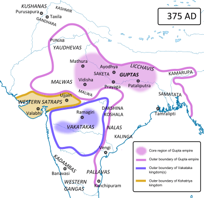
The Kingdom of Samatata (or Samata) was an ancient kingdom during the Classical period on the Indian subcontinent, located at the mouth of the Brahmaputra river in the south east of Bengal.[1] It was a vassal to the Gupta Empire.
Samatata was created following the collapse of the Mauryan Empire, sometime after the death of Emperor Ashoka in 232 BC. They are believed to have been incorporated into the Gupta Empire by Samudragupta, around 335 CE:
(Lines 22–23) (Samudragupta, whose) formidable rule was propitiated with the payment of all tributes, execution of orders and visits (to his court) for obeisance by such frontier rulers as those of Samataṭa, Ḍavāka, Kāmarūpa, Nēpāla, and Kartṛipura, and, by the Mālavas, Ārjunāyanas, Yaudhēyas, Mādrakas, Ābhīras, Prārjunas, Sanakānīkas, Kākas, Kharaparikas and other (tribes)."
Not much is known about the kingdom's history, except that it was ruled by Buddhist kings in the late 7th century.
The Roman geographer Ptolemy called the kingdom Souanagoura (modern Sonargaon)[2]. Two ancient Chinese travelers also mention Samatata in their travels. In the early 7th century a monk named Xuanzang called it "San-mo-tat'a" and indicates the kingdom was a Buddhist center. He gave the distance between Kamarupa and Samatata as 1300 li. He further revealed that the land was low and moist and roughly 3000 li in circuit. Samatata was visited nearly a century later by another Chinese monk, Yijing.
As of April 2010, archaeological excavations are currently underway in the villages of Wari and Bateshwar uncovering the ruins of a fortress city of Samatata.
Buddhist monument
Part of a series on the |
|---|
| History of Bengal |
 |
|
Ancient Geopolitical units |
|
Medieval and Early Modern periods |
|
European colonisation
|
|
Calendar |
- Asrama vihara: a Vihara, or an educational centre with residential facilities.[3]
References
- ↑ AM Chowdhury (2012), "Samatata", in Sirajul Islam and Ahmed A. Jamal, Banglapedia: National Encyclopedia of Bangladesh (Second ed.), Asiatic Society of Bangladesh
- ↑ "First, in his list of towns in transgangetic India Ptolemy mentions a place called Souanagoura which has been identified with modern Sonargaon" Excavation at Wari-Bateshwar: A Preliminary Study, Enamul Haque - 2001
- ↑ Huu Phuoc Le (2010). Buddhist Architecture. Grafikol. pp. 71–. ISBN 978-0-9844043-0-8.