Tacheng
| Tacheng 塔城市 چۆچەك شەھىرى | |
|---|---|
| County-level city | |
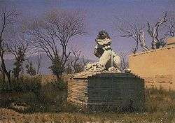 "Ruins in Chuguchak" by Vasily Vereshchagin (1869) | |
.png) Location of Tacheng City (pink) in Tacheng Prefecture (yellow) and Xinjiang | |
 Tacheng Location of the city centre in Xinjiang | |
| Coordinates: 46°45′N 82°59′E / 46.750°N 82.983°ECoordinates: 46°45′N 82°59′E / 46.750°N 82.983°E | |
| Country | People's Republic of China |
| Autonomous region | Xinjiang |
| Prefecture | Tacheng |
| Area | |
| • Total | 4,007 km2 (1,547 sq mi) |
| Population (2003) | |
| • Total | 160,000 |
| • Density | 40/km2 (100/sq mi) |
| Time zone | UTC+8 (China Standard) |
| Postal code | 834700 |
| Tacheng | |||||||||
| Chinese name | |||||||||
|---|---|---|---|---|---|---|---|---|---|
| Chinese | 塔城 | ||||||||
| |||||||||
| Alternative Chinese name | |||||||||
| Chinese | 缺切克 | ||||||||
| |||||||||
| Second alternative Chinese name | |||||||||
| Chinese | 楚呼楚 | ||||||||
| |||||||||
| Third alternative Chinese name | |||||||||
| Simplified Chinese | 塔尔巴哈台 | ||||||||
| Traditional Chinese | 塔爾巴哈台 | ||||||||
| |||||||||
| Uyghur name | |||||||||
| Uyghur |
چۆچەك | ||||||||
| |||||||||
| Kazakh name | |||||||||
| Kazakh |
شاۋەشەك Şäwesek | ||||||||
Tacheng[1] as the official romanized name, also transliterated from Mongolian as Qoqak, is a county-level city (1994 est. pop. 56,400) and the administrative seat of Tacheng Prefecture, in northern Ili Kazakh Autonomous Prefecture, Xinjiang, one of the autonomous regions of China.
The city was sometimes called Tarbaghatay or Tarbagatai (Mongolian: 'having marmots') and was once known in European languages as Chuguchak (based on its name in the Mongolian language).[2] The current official Chinese name Tacheng is an abbreviation of "Tarbaghatay City". The current Uyghur name is Qöqäk transliterated from Mongolian.
It is located in the Dzungarian Basin, some 10 km (6.2 mi) from the Chinese border with Kazakhstan. For a long time it has been a major center for trade with Central Asia because it is an agricultural hub. Its industries include food processing, textiles, and utilities.
History
In the mid-19th century, Chuguchak was considered the most important commercial center of Western China after Ghulja (Yining), being an important center of trade between China and Russia, in particular in tea. The city, surrounded by an earth wall, was the residence of two Qing ambans, and had a garrison of some 1,000 Chinese soldiers and 1,500 Manchu and Mongol soldiers.[2]
Chuguchak suffered harshly in 1865, during the fighting between the Qing forces and the Dungan and Uyghur rebels.
Border crossing
The Bakhtu border crossing into Kazakhstan is located 17 km (11 mi) from Tacheng. The checkpoint on the Kazakh side of the border is also known as Bakhty and is located 60 km (37 mi) from Makanchi in East Kazakhstan province. The border has been closed since 2009 for traffic both ways.
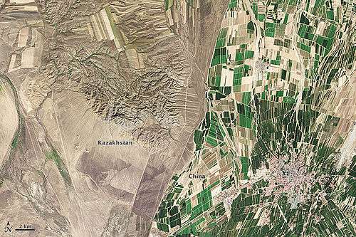 Kazakh-Chinese border near Tacheng
Climate
Tacheng has a typical Central Asian and Xinjiang cool semi-arid climate (Köppen BSk) that is almost moist enough to be a hot summer humid continental climate (Köppen Dfa), as being on the west side of the Altay Mountains the region receives more winter snowfall than most of Xinjiang.
| Climate data for Tacheng (1971−2000) | |||||||||||||
|---|---|---|---|---|---|---|---|---|---|---|---|---|---|
| Month | Jan | Feb | Mar | Apr | May | Jun | Jul | Aug | Sep | Oct | Nov | Dec | Year |
| Record high °C (°F) | 7.6 (45.7) |
9.6 (49.3) |
24.7 (76.5) |
33.2 (91.8) |
34.9 (94.8) |
37.2 (99) |
40.3 (104.5) |
41.3 (106.3) |
37.7 (99.9) |
32.0 (89.6) |
20.8 (69.4) |
11.8 (53.2) |
41.3 (106.3) |
| Average high °C (°F) | −4.1 (24.6) |
−2.3 (27.9) |
4.1 (39.4) |
17.0 (62.6) |
23.4 (74.1) |
28.4 (83.1) |
30.8 (87.4) |
29.9 (85.8) |
24.1 (75.4) |
15.0 (59) |
4.3 (39.7) |
−2 (28) |
14.1 (57.3) |
| Daily mean °C (°F) | −10.4 (13.3) |
−8.7 (16.3) |
−1.8 (28.8) |
9.7 (49.5) |
15.9 (60.6) |
20.7 (69.3) |
22.9 (73.2) |
21.6 (70.9) |
15.8 (60.4) |
7.6 (45.7) |
−1.2 (29.8) |
−7.4 (18.7) |
7.1 (44.7) |
| Average low °C (°F) | −15.6 (3.9) |
−14.1 (6.6) |
−7 (19) |
3.6 (38.5) |
9.2 (48.6) |
13.6 (56.5) |
15.7 (60.3) |
14.1 (57.4) |
8.5 (47.3) |
1.9 (35.4) |
−5.6 (21.9) |
−12 (10) |
1 (33.8) |
| Record low °C (°F) | −33.5 (−28.3) |
−37.1 (−34.8) |
−30.6 (−23.1) |
−12.3 (9.9) |
−3.7 (25.3) |
2.6 (36.7) |
6.2 (43.2) |
4.0 (39.2) |
−4.1 (24.6) |
−13.3 (8.1) |
−31.5 (−24.7) |
−34.7 (−30.5) |
−37.1 (−34.8) |
| Average precipitation mm (inches) | 16.5 (0.65) |
14.4 (0.567) |
15.6 (0.614) |
32.4 (1.276) |
31.7 (1.248) |
24.5 (0.965) |
29.8 (1.173) |
16.3 (0.642) |
14.0 (0.551) |
26.9 (1.059) |
34.3 (1.35) |
25.9 (1.02) |
282.3 (11.115) |
| Average precipitation days (≥ 0.1 mm) | 8.9 | 8.5 | 8.3 | 8.2 | 9.4 | 7.9 | 8.4 | 6.3 | 6.0 | 7.5 | 10.0 | 9.7 | 99.1 |
| Source: Weather China | |||||||||||||
Transportation
The Karamay–Tacheng Railway (under construction as of 2017) will connect Tacheng with Baikouquan Station (百口泉站) on the Kuytun–Beitun Railway in Karamay City. [3]
References
- ↑ The official spelling according to Zhōngguó dìmínglù 中国地名录 (Beijing, SinoMaps Press 中国地图出版社 1997); ISBN 7-5031-1718-4
- 1 2 Lumley, John (1869), Report by Mr. Lumley, Her Majesty's Secretary of Embassy at St. Petersburgh, on the Tea Trade of Russia, dated May 4, 1867. [Extracted from “Commercial reports” presented to Parliament, July 1867.], p. 73
- ↑ 克塔铁路站后工程开工建设, 2017-9-28
- Khālidī, Qurbanʻali, Allen J. Frank, and Mirkasym Abdulakhatovich Usmanov. An Islamic Biographical Dictionary of the Eastern Kazakh Steppe, 1770-1912. Brill's Inner Asian library, v. 12. Leiden: Brill, 2004.
- Light, Nathan. "Qazaqs in the People's Republic of China: The Local Processes of History". Bloomington, Indiana: Indiana Center on Global Change and World Peace, Occasional Paper No. 22, June 1994. ISBN 1-881157-24-5.
- Light, Nathan. "Kazakhs of the Tarbaghatai: Ethno-History Through a Novel". The Turkish Studies Association Bulletin, 17/2 (1993): 91-102.
- Saguchi Toru. "Kazak Pastoralists on the Tarbaghatai Frontier under the Ch'ing." In: Proceedings of the International Conference on China Border Area Studies. Lin En-hsien [Lin Enxian], ed. Taipei: National Chengchi University, 1985, pp. 953–996.
- Wiens, Herold J. "Change in the Ethnography and Land Use of the Ili Valley and Region, Chinese Turkestan". Annals of the Association of American Geographers, Vol. 59, No. 4. (Dec., 1969), pp. 753–775.
External links
| Wikimedia Commons has media related to Tacheng. |
- Map of the City of Tacheng (in Chinese)
- Webpage on the Bakktu border crossing in Xinjiang's Land Ports and Border Trade website