Chapmanville, West Virginia
| Chapmanville, West Virginia | |
|---|---|
| Town | |
 Chapmanville | |
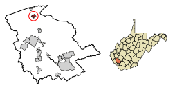 Location of Chapmanville in Logan County, West Virginia. | |
| Coordinates: 37°58′18″N 82°1′12″W / 37.97167°N 82.02000°WCoordinates: 37°58′18″N 82°1′12″W / 37.97167°N 82.02000°W | |
| Country | United States |
| State | West Virginia |
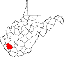
| County | Logan |
| Area[1] | |
| • Total | 0.67 sq mi (1.74 km2) |
| • Land | 0.65 sq mi (1.68 km2) |
| • Water | 0.02 sq mi (0.05 km2) |
| Elevation | 640 ft (195 m) |
| Population (2010)[2] | |
| • Total | 1,256 |
| • Estimate (2016)[3] | 1,171 |
| • Density | 1,932.3/sq mi (746.1/km2) |
| Time zone | UTC-5 (Eastern (EST)) |
| • Summer (DST) | UTC-4 (EDT) |
| ZIP code | 25508 |
| Area code(s) | 304 |
| FIPS code | 54-14524[4] |
| GNIS feature ID | 1537207[5] |
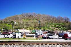
Chapmanville is a town in Logan County, West Virginia, in the United States. The population was 1,256 at the 2010 census. Chapmanville was founded in 1800 and named for Ned Chapman, an early settler who operated a store and post office.[6] It was incorporated in 1947.[7]
Geography
Chapmanville is located in northern Logan County at 37°58′18″N 82°1′12″W / 37.97167°N 82.02000°W (37.971615, -82.020017).[8] It is situated along the Guyandotte River at a point where the northward-flowing river briefly bends sharply southwestwardly before turning north again.[9] The community of Phico lies just south of Chapmanville.
U.S. Route 119 and West Virginia Route 10, both of which approach from Logan to the south, intersect in Chapmanville. From this intersection, WV 10 continues northward in the direction of Huntington, while US 119 veers northeastward toward Charleston.
According to the United States Census Bureau, the town has a total area of 0.67 square miles (1.74 km2), of which, 0.65 square miles (1.68 km2) is land and 0.02 square miles (0.05 km2) is water.[1]
Demographics
| Historical population | |||
|---|---|---|---|
| Census | Pop. | %± | |
| 1950 | 1,349 | — | |
| 1960 | 1,241 | −8.0% | |
| 1970 | 1,175 | −5.3% | |
| 1980 | 1,164 | −0.9% | |
| 1990 | 1,110 | −4.6% | |
| 2000 | 1,211 | 9.1% | |
| 2010 | 1,256 | 3.7% | |
| Est. 2016 | 1,171 | [3] | −6.8% |
| U.S. Decennial Census[10] | |||
2010 census
As of the census[2] of 2010, there were 1,256 people, 604 households, and 338 families residing in the town. The population density was 1,932.3 inhabitants per square mile (746.1/km2). There were 667 housing units at an average density of 1,026.2 per square mile (396.2/km2). The racial makeup of the town was 98.2% White, 0.2% African American, 0.6% Asian, 0.4% from other races, and 0.6% from two or more races. Hispanic or Latino of any race were 1.4% of the population.
There were 604 households of which 26.7% had children under the age of 18 living with them, 38.7% were married couples living together, 12.4% had a female householder with no husband present, 4.8% had a male householder with no wife present, and 44.0% were non-families. 40.2% of all households were made up of individuals and 21.2% had someone living alone who was 65 years of age or older. The average household size was 2.08 and the average family size was 2.77.
The median age in the town was 42.4 years. 18.4% of residents were under the age of 18; 7.2% were between the ages of 18 and 24; 27.1% were from 25 to 44; 27.5% were from 45 to 64; and 19.7% were 65 years of age or older. The gender makeup of the town was 46.1% male and 53.9% female.
2000 census
As of the census[4] of 2000, there were 1,211 people, 581 households, and 330 families residing in the town. The population density was 1,797.4 inhabitants per square mile (697.9/km²). There were 658 housing units at an average density of 976.6 per square mile (379.2/km²). The racial makeup of the town was 98.84% White, 0.74% Asian, and 0.41% from two or more races. Hispanic or Latino of any race were 0.41% of the population.
There were 581 households out of which 23.1% had children under the age of 18 living with them, 40.8% were married couples living together, 13.8% had a female householder with no husband present, and 43.2% were non-families. 40.3% of all households were made up of individuals and 20.0% had someone living alone who was 65 years of age or older. The average household size was 2.08 and the average family size was 2.82.
In the town, the population was spread out with 19.0% under the age of 18, 9.5% from 18 to 24, 26.5% from 25 to 44, 25.1% from 45 to 64, and 19.9% who were 65 years of age or older. The median age was 41 years. For every 100 females, there were 77.0 males. For every 100 females age 18 and over, there were 76.4 males.
The median income for a household in the town was $23,077, and the median income for a family was $38,250. Males had a median income of $28,500 versus $20,769 for females. The per capita income for the town was $15,581. About 12.1% of families and 20.3% of the population were below the poverty line, including 31.7% of those under age 18 and 16.4% of those age 65 or over.
Education
Chapmanville is home to Chapmanville Regional High School, West Virginia's first cross-county consolidated high school, which includes grades 9-12. The town is also home to one middle school, Chapmanville Middle School (grades 5-8), and two elementary schools, West Chapmanville and East Chapmanville (Pre-Kindergarten through grade 4). Chapmanville hosts the second largest student population in the county. The student body consists of students from a consolidation agreement with the West Virginia Department of Education, West Virginia School Building Authority, Lincoln County Schools and Logan County Schools that consolidated Harts High School and Chapmanville High School to form Chapmanville Regional High School. It opened on June 1, 2007. All schools in the city use the tiger as their mascot.[11]
Notable people
- Shane Burton, retired American football defensive tackle
- Danny Godby, Major League Baseball player
- Earl Ray Tomblin, former Governor of West Virginia
- Chris Ojeda, musician, Byzantine
References
- 1 2 "US Gazetteer files 2010". United States Census Bureau. Archived from the original on 2012-01-24. Retrieved 2013-01-24.
- 1 2 "American FactFinder". United States Census Bureau. Retrieved 2013-01-24.
- 1 2 "Population and Housing Unit Estimates". Retrieved June 9, 2017.
- 1 2 "American FactFinder". United States Census Bureau. Archived from the original on 2013-09-11. Retrieved 2008-01-31.
- ↑ "US Board on Geographic Names". United States Geological Survey. 2007-10-25. Retrieved 2008-01-31.
- ↑ Kenny, Hamill (1945). West Virginia Place Names: Their Origin and Meaning, Including the Nomenclature of the Streams and Mountains. Piedmont, WV: The Place Name Press. p. 164.
- ↑ West Virginia Blue Book. Published annually by the Clerk's Office of the West Virginia Senate.
- ↑ "US Gazetteer files: 2010, 2000, and 1990". United States Census Bureau. 2011-02-12. Retrieved 2011-04-23.
- ↑ West Virginia Atlas & Gazetteer. Yarmouth, Me.: DeLorme. 1997. p. 51. ISBN 0-89933-246-3.
- ↑ "Census of Population and Housing". Census.gov. Archived from the original on May 12, 2015. Retrieved June 4, 2015.
- ↑ Logan County Schools. Retrieved: 25 April 2018.
- The Charleston Daily Ver. 1613 May 6, 1999.
External links