Neibert, West Virginia
| Neibert, West Virginia | |
|---|---|
| Census-designated place | |
 Neibert Bottom Road | |
 Neibert, West Virginia | |
| Coordinates: 37°47′17″N 81°56′30″W / 37.78806°N 81.94167°WCoordinates: 37°47′17″N 81°56′30″W / 37.78806°N 81.94167°W | |
| Country | United States |
| State | West Virginia |
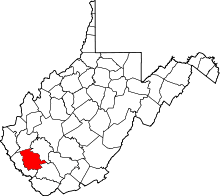
| County | Logan |
| Area[1] | |
| • Total | 0.630 sq mi (1.63 km2) |
| • Land | 0.612 sq mi (1.59 km2) |
| • Water | 0.018 sq mi (0.05 km2) |
| Elevation | 718 ft (219 m) |
| Population (2010)[2] | |
| • Total | 183 |
| • Density | 290/sq mi (110/km2) |
| Time zone | UTC-5 (Eastern (EST)) |
| • Summer (DST) | UTC-4 (EDT) |
| Area code(s) | 304 & 681 |
| GNIS feature ID | 1544085[3] |
Neibert is a census-designated place in Logan County, West Virginia, United States. Its population was 183 as of the 2010 census.[2]
References
- ↑ "US Gazetteer files: 2010, 2000, and 1990". United States Census Bureau. 2011-02-12. Retrieved 2011-04-23.
- 1 2 "American FactFinder". United States Census Bureau. Retrieved 2011-05-14.
- ↑ U.S. Geological Survey Geographic Names Information System: Neibert, West Virginia
This article is issued from
Wikipedia.
The text is licensed under Creative Commons - Attribution - Sharealike.
Additional terms may apply for the media files.