Stirrat, West Virginia
| Stirrat, West Virginia | |
|---|---|
| Unincorporated community | |
 Coal conveyor in Stirrat | |
 Stirrat, West Virginia  Stirrat, West Virginia | |
| Coordinates: 37°43′35″N 82°00′08″W / 37.72639°N 82.00222°WCoordinates: 37°43′35″N 82°00′08″W / 37.72639°N 82.00222°W | |
| Country | United States |
| State | West Virginia |
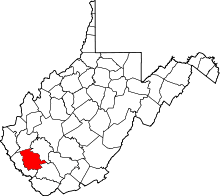
| County | Logan |
| Elevation | 912 ft (278 m) |
| Time zone | UTC-5 (Eastern (EST)) |
| • Summer (DST) | UTC-4 (EDT) |
| Area code(s) | 304 & 681 |
| GNIS feature ID | 1555715[1] |
Stirrat is an unincorporated community in Logan County, West Virginia, United States. Stirrat is located along Island Creek and West Virginia Route 44 8.4 miles (13.5 km) south of Logan.[2]
References
- ↑ "Stirrat". Geographic Names Information System. United States Geological Survey.
- ↑ Logan County, West Virginia General Highway Map (PDF) (Map). West Virginia Department of Transportation. 2011. p. 2. Archived from the original (PDF) on 2012-02-06. Retrieved October 27, 2011.
This article is issued from
Wikipedia.
The text is licensed under Creative Commons - Attribution - Sharealike.
Additional terms may apply for the media files.