Breckland District
| Breckland District | |
|---|---|
| Non-metropolitan district | |
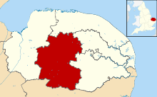 Breckland shown within Norfolk | |
| Sovereign state | United Kingdom |
| Constituent country | England |
| Region | East of England |
| Non-metropolitan county | Norfolk |
| Status | Non-metropolitan district |
| Admin HQ | East Dereham |
| Incorporated | 1 April 1974 |
| Government | |
| • Type | Non-metropolitan district council |
| • Body | Breckland District Council |
| • Leadership | Leader & Cabinet (Conservative) |
| • MPs |
George Freeman Elizabeth Truss |
| Area | |
| • Total | 399.7 sq mi (1,035.1 km2) |
| Area rank | 16th (of 326) |
| Population (mid-2017 est.) | |
| • Total | 138,600 |
| • Rank | 156th (of 326) |
| • Density | 350/sq mi (130/km2) |
| • Ethnicity | 98.5% White |
| Time zone | UTC0 (GMT) |
| • Summer (DST) | UTC+1 (BST) |
| ONS code |
33UB (ONS) E07000143 (GSS) |
| OS grid reference | TG018081 |
| Website |
www |
Breckland District is a local government district in Norfolk, England. Its head office is located at Elizabeth House, Walpole Loke, East Dereham, Norfolk, NR19 1EE. It is a second tier local government authority that sits below Norfolk County Council.
The population of the council at the 2011 Census was 130,491.[1]
Breckland District Council derives its name from the Breckland landscape region, a gorse-covered sandy heath of south Norfolk and north Suffolk. The term Breckland is ancient, and is found as early as the 13th century in the form Brakelond.
History
Breckland District Council was formed on 1 April 1974 by the merger of the Borough of Thetford, East Dereham Urban District, Swaffham Urban District, Wayland Rural District, Mitford and Launditch Rural District, and Swaffham Rural District.
Politics
The Council consists of 49 Councillors elected every four years, the last election being 2015.
It is currently controlled by the Conservative Party who won 42 of the 49 seats on the council at the last election.
Leader of the Council
The Leader is Cllr. William Nunn (Conservative)
The Deputy Leader is Cllr. Sam Chapman Allen (Conservative)
Chairman of the Council
The Chairman is Cllr. Richard Duffield (Lincoln Ward)
The Vice-Chairman is Cllr. Lynda Turner (Shipdham Ward)
Past Chairmen of the Council
- 2017-2018 Cllr. Kate Millbank (Dereham Tofwood Ward)
- 2016-2017 Cllr. Bill Borrett (Upper Wensum Ward)
- 2015-2016 Cllr. Gordon Bambridge (Upper Wensum Ward)
- 2014-2015 Cllr. Robert Kybird (Thetford Guildhall Ward)
- 2013-2014 Cllr. Paul Claussen (Two Rivers Ward)
- 2012-2013 Cllr. Robin Goreham (Dereham Central Ward)
- 2011-2012 Cllr. Nigel Wilkin (Necton Ward)
Election Results
For the results of the last election to the council click on this link, Breckland District Council election, 2015
For further information on previous elections click on link, Breckland District Council -elections
Composition
The council is entirely parished, and is made up of 113 civil parishes. At the time of the 2001 census, the district had an area of 1,305 km2 (504 sq mi), with a population of 121,418 in 50,715 households.[2]
The council contains the following civil parishes:
- Ashill, Attleborough
- Banham, Bawdeswell, Beachamwell, Beeston with Bittering, Beetley, Besthorpe, Billingford, Bintree, Blo' Norton, Bradenham, Brettenham, Bridgham, Brisley, Bylaugh
- Carbrooke, Caston, Cockley Cley, Colkirk, Cranwich, Cranworth, Croxton
- Didlington, Dereham
- East Tuddenham, Elsing
- Foulden, Foxley, Fransham
- Garboldisham, Garvestone, Gateley, Gooderstone, Great Cressingham, Great Dunham, Great Ellingham, Great Hockham, Gressenhall, Griston, Guist
- Hardingham, Harling, Hilborough, Hockering, Hoe, Holme Hale, Horningtoft
- Ickburgh
- Kempstone, Kenninghall, Kilverstone
- Lexham, Litcham, Little Cressingham, Little Dunham, Little Ellingham, Longham, Lynford, Lyng
- Mattishall, Merton, Mileham, Mundford
- Narborough, Narford, Necton, New Buckenham, Newton by Castle Acre, North Elmham, North Lopham, North Pickenham, North Tuddenham
- Old Buckenham, Ovington, Oxborough
- Quidenham
- Riddlesworth, Rocklands, Rockland St Peter, Roudham and Larling, Rougham
- Saham Toney, Scarning, Scoulton, Shipdham, Shropham, Snetterton, South Acre, South Lopham, South Pickenham, Sparham, Sporle with Palgrave, Stanfield, Stanford, Stow Bedon, Sturston, Swaffham, Swanton Morley,
- Thetford, Thompson, Tittleshall, Tottington, Twyford
- Watton, Weasenham All Saints, Weasenham St. Peter, Weeting-with-Broomhill, Wellingham, Wendling, Whinburgh and Westfield, Whissonsett, Wretham
- Yaxham
References
- ↑ "Local Authority District population 2011". Neighbourhood Statistics. Office for National Statistics. Retrieved 26 July 2016.
- ↑ Office for National Statistics & Norfolk County Council (2001). Census population and household counts for unparished urban areas and all parishes. Retrieved 2 December 2005.
External links
- Diss Express - website of local newspaper covering part of district
Districts of the East of England | ||
|---|---|---|
| Bedfordshire |  | |
| Cambridgeshire | ||
| Essex | ||
| Hertfordshire | ||
| Norfolk | ||
| Suffolk |
| |