Swaffham Rural District
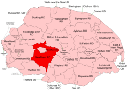 Boundaries in 1894 |
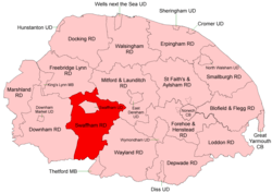 Boundaries in 1935 |
Swaffham Rural District was a rural district in Norfolk, England from 1894 to 1974.[1]
It was formed under the Local Government Act 1894 based on the Swaffham rural sanitary district. It almost completely encircled Swaffham Urban District.
In 1935 it took in a small part of Downham Rural District to complete the encirclement of urban Swaffham. It also took in the central section of the disbanded Thetford Rural District.
In 1974, the district was abolished under the Local Government Act 1972, and became part of the Breckland district.
Statistics
| Year | Area (ha) [2] |
Population [3] |
Density (pop/ha) |
|---|---|---|---|
| 1911 | 30,172 | 7,571 | 0.25 |
| 1921 | 7,237 | 0.24 | |
| 1931 | 6,769 | 0.22 | |
| 1951 | 37,724 | 10,606 | 0.28 |
| 1961 | 9,164 | 0.24 |
Parishes
| Parish | From | To | Notes |
|---|---|---|---|
| Ashill | |||
| Beachamwell | 1935 | Merger of Beechamwell and Shingham | |
| Beechamwell | 1935 | ||
| Bodney | 1935 | Added to Hilborough | |
| Bradenham | 1952 | Merger of East Bradenham and West Bradenham | |
| Buckenham Tofts | 1935 | Added to Stanford | |
| Caldecote | 1935 | Added to Oxborough | |
| Cockley Cley | |||
| Colveston | 1935 | Added to Didlington | |
| Cranwich | 1935 | Formerly Thetford RD | |
| Didlington | |||
| East Bradenham | 1952 | Component of Bradenham | |
| Foulden | |||
| Gooderstone | |||
| Great Cressingham | |||
| Hilborough | |||
| Holme Hale | |||
| Houghton on the Hill | 1935 | Added to North Pickenham | |
| Ickburgh | |||
| Langford | 1935 | Added to Ickburgh | |
| Little Cressingham | |||
| Lynford | 1935 | Formerly Thetford RD (including Santon and West Tofts) | |
| Mundford | 1935 | Formerly Thetford RD | |
| Narborough | |||
| Narford | |||
| Necton | |||
| Newton by Castle Acre | |||
| North Pickenham | |||
| Oxborough | |||
| Saham Toney | |||
| Shingham | 1935 | Component of Beachamwell | |
| South Acre | |||
| South Pickenham | |||
| Sporle with Palgrave | |||
| Stanford | |||
| Sturston | 1935 | Formerly Thetford RD | |
| Threxton | 1935 | Added to Little Cressingham | |
| Weeting with Broomhill | 1935 | Formerly Thetford RD | |
| West Bradenham | 1952 | Component of Bradenham |
References
- ↑ "Swaffham RD through time: Census tables with data for the Local Government District". A Vision of Britain through Time. GB Historical GIS / University of Portsmouth. Retrieved 26 June 2017.
- ↑ "Swaffham RD through time: Population Statistics: Area (acres)". A Vision of Britain through Time. GB Historical GIS / University of Portsmouth. Retrieved 26 Jun 2017.
- ↑ "Swaffham RD through time: Population Statistics: Total Population". A Vision of Britain through Time. GB Historical GIS / University of Portsmouth. Retrieved 26 Jun 2017.
This article is issued from
Wikipedia.
The text is licensed under Creative Commons - Attribution - Sharealike.
Additional terms may apply for the media files.