Roudham and Larling
| Roudham and Larling | |
|---|---|
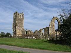 Ruins of St Andrew's Church | |
 Roudham and Larling Roudham and Larling shown within Norfolk | |
| Area | 15.20 km2 (5.87 sq mi) |
| Population | 301 (2001)[1] |
| • Density | 20/km2 (52/sq mi) |
| OS grid reference | TL977882 |
| • London | 94.8 miles |
| Civil parish |
|
| District | |
| Shire county | |
| Region | |
| Country | England |
| Sovereign state | United Kingdom |
| Post town | NORWICH |
| Postcode district | NR16 |
| Police | Norfolk |
| Fire | Norfolk |
| Ambulance | East of England |
| EU Parliament | East of England |
| UK Parliament |
|
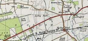
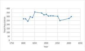
Roudham and Larling is a civil parish in the English county of Norfolk. It covers an area of 15.20 km2 (5.87 sq mi) and had a population of 278 in 119 households at the 2001 census,[2] increasing to a population of 301 in 119 households at the 2011 Census. For the purposes of local government, it falls within the district of Breckland. River Thet flows next to Roudham and Larling.
History
The parish of Roudham and Larling is formed from the two ancient parishes which centred round the churches of St Andrew in Roudham and St Botolph in Larling.[3] Up until 1894 all the duties usually performed by a local government were fulfilled by the churches, until the Local Government Act of 1984 which created civil parishes alongside ecclesiastical ones.[4] The two parishes were known as separate ones for many years, when on the 14th August 2000 at the request of Breckland council who declared a Notice of the Change of the Parish Name,[5] making the civil parish now be more commonly known as Roudham and Larling.
The name Roudham has been thought to be derived from the old English meaning 'homestead where rue plants are grown.'[6] A decline in population during the late Medieval period meant the village was abandoned and is now considered one of the best examples of a deserted Medieval settlement in Norfolk. After extensive archaeological research and the research into medieval findings it appears that the village of Roudham was thriving off the production of flint tools such as scrapers and arrowheads. For the early part the parish was a busy place, and judging by many barns and farmhouses it would have been heavily involved in agriculture. In the 19th century the Norfolk Railway opened which had a major impact on commuting into the area as well as the significant improvements in trade.[7] The railway is still in use and has connections to the major towns and villages nearby.
The most recent archaeological findings date back to the First and Second World War. The Harling Road was used as one of the bases for fighter aircraft in First World War, and in the Second World War it was the base for the US army's 513th Ordnance Company, who maintained heavy armoured vehicles.[8] The majority of the area is now used as a wasteland, with only a few buildings remaining after the War.
Demography
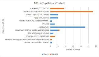
In 1881, the main occupation of the parish was agriculture with 23% of men working within that sector,[9] of the women, the most common occupations revolved around domestic services or offices with 3% of the women working within that sector.[10] It does appear however that as much as 29% of women were without specified occupations, and it would appear that the men would be the main bread winners in households. The occupation structure of Roudham and Larling as of 2011 still remains highly orientated around agriculture and manual labour. The 2011 census shows that approximately 40% out of 180 in the age group of being economically active being employed in the Agricultural, Forestry and Fishing industry.[11] The industry which shows to have increased and now employs the most residents is 'Wholesale and Retail Trade; Repair of Motor Vehicles and Motor Cycles' at 54% of the working population.[12]
The only prominent religion in Roudham and Larling is Christianity at approximately 66% of the population.[13] The ethnic composition of the parish is dominated by 'White; English/Welsh/Scottish/Northern Irish/British' with 95.3% of a total population of 301 people falling into that group.
Education
The parish does not have a local village school, but there are several schools in nearby villages such as; The New Eccles Hall School, Great Hockam Primary School, Eccles Hargham and Wilby CofE Primary School. The school in closest proximity to the civil parish is East Harling Primary School and Nursery. It is approximately 3 km away and is for ages 3–11. The latest reports from May 2015 show that 224 pupils attended the school in total, ranging from pre-school to year 6. The most recent report from November 2014, rated the school as 'Requiring Improvement.'
Tourist Attractions
Ruins of St Andrew's Church
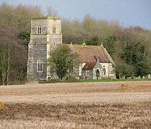
The parish is centred round the ruinous church remains of St Andrew's Church. The church was abandoned in 1736 after a destructive fire, although it remains to this day with all the walls remaining at their original height, the structure of the building is very weak.[14] The church remains a significant monument in the landscape, however due to its weak condition, it had to be cordoned off due to the danger of it collapsing. Negotiations for the repair of the church are in progress.
St Ethelbert Church
The still-standing medieval church was built in the 12th century, and was expanded in the 1340s creating the chancel, with a tower later being added in the 16th century.[15] The walls used to be covered in decorative paintings, one of them including a large painting of St Christopher. An organisation under the name 'Friends of Thurton Church' continue to help raise money for future restorations and the ongoing maintenance of the church.
Shrubb Family (Shrubb Cottage)
Founded in the 1969, the Shrubb family is the longest running community in England. The members pride themselves on having a very care free ethos and are actively promoting communal and eco-friendly living. The community accommodates many individual interests ranging from fine arts and politics, to the legalisation of drugs. As of recent years the membership of the group has fluctuated and has been left with around 6 members.[16]
References
- ↑ "Civil Parish population 2011". Neighbourhood Statistics. Office for National Statistics. Retrieved 7 August 2016.
- ↑ Census population and household counts for unparished urban areas and all parishes Archived 11 February 2017 at the Wayback Machine.. Office for National Statistics & Norfolk County Council (2001). Retrieved 20 June 2009.
- ↑ "Roudham and Larling Parish Council". Norfolk Parishes. Roudham and Larling Parish Council. 11 March 2011. Retrieved 24 April 2016.
- ↑ "Roudham and Larling Parish Council". Norfolk Parishes. Roudham and Larling Parish Council. 11 March 2011. Retrieved 24 April 2016.
- ↑ "Roudham and Larling Parish Council". Norfolk Parishes. Roudham and Larling Parish Council. 11 March 2011. Retrieved 24 April 2016.
- ↑ Sunley, Thomas (10 April 2007). "Norfolk Heritage Explorer". Norfolk Heritage Explorer. Norfolk County Council. Retrieved 24 April 2016.
- ↑ Sunley, Thomas (10 April 2007). "Norfolk Heritage Explorer". Norfolk Heritage Explorer. Norfolk County Council. Retrieved 24 April 2016.
- ↑ Sunley, Thomas (10 April 2007). "Norfolk Heritage Explorer". Norfolk Heritage Explorer. Norfolk County Council. Retrieved 24 April 2016.
- ↑ "Roudham AP/CP through time | Industry Statistics". A Vision of Britain. GB Historical GIS/University of Porstmouth. Retrieved 24 April 2016.
- ↑ "Roudham AP/CP through time | Industry Statistics". The Vision of Britain. GB Historical GIS/University of Portsmouth. Retrieved 24 April 2016.
- ↑ "Roudham and Larling key statistics 2011". Neighbourhood Statistics. Office for National Statistics. Retrieved 24 April 2016.
- ↑ "Roudham and Larling key statistics 2011". Neighbourhood Statistics. Office for National Statistics. Retrieved 24 April 2016.
- ↑ "Roudham and Larling key statistics 2011". Neighbourhood Statistics. Office for National Statistics. Retrieved 24 April 2016.
- ↑ Sunley, Thomas (10 April 2007). "Norfolk Heritage Explorer". Norfolk Heritage Explorer. Norfolk County Council. Retrieved 24 April 2016.
- ↑ "The Church of England". The Church of England. Archibishops' Council. 2016. Retrieved 24 April 2016.
- ↑ Ansell, Vera. "Diggers and Dreamers". Diggers and Dreamers: the guide to communal living. Retrieved 24 April 2016.
| Wikimedia Commons has media related to Roudham and Larling. |