Sparham
| Sparham | |
|---|---|
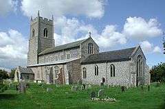 St Mary's Church | |
 Sparham Sparham shown within Norfolk | |
| Area | 7.22 km2 (2.79 sq mi) |
| Population | 341 (2011)[1] |
| • Density | 47/km2 (120/sq mi) |
| OS grid reference | TG071196 |
| Civil parish |
|
| District | |
| Shire county | |
| Region | |
| Country | England |
| Sovereign state | United Kingdom |
| Post town | NORWICH |
| Postcode district | NR9 |
| Police | Norfolk |
| Fire | Norfolk |
| Ambulance | East of England |
| EU Parliament | East of England |
Sparham is a village and civil parish in Norfolk, England. It covers an area of 7.22 km2 (2.79 sq mi) and had a population of 291 in 109 households at the 2001 census,[2] including Bylaugh and increasing to a population of 341 in 143 households at the 2011 census. For the purposes of local government, it falls within the Upper Wensum Ward of Breckland District Council and the Elmham and Mattishall Division of Norfolk County Council.
Sparham is one of the highest points in Norfolk, and the top of the church tower has views of the surrounding countryside for several miles.
The hamlet of Sparhamhill lies to its east and south on the main A1067 road.
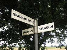
As well as Sparham and Sparhamhill there are also Sparham Hole and Sparham Hall
Notes
- ↑ "Civil Parish population 2011". Neighbourhood Statistics. Office for National Statistics. Retrieved 31 July 2016.
- ↑ Census population and household counts for unparished urban areas and all parishes Archived 2017-02-11 at the Wayback Machine.. Office for National Statistics & Norfolk County Council (2001). Retrieved 20 June 2009.
See also
![]()
Destinations from Sparham | |
|---|---|
This article is issued from
Wikipedia.
The text is licensed under Creative Commons - Attribution - Sharealike.
Additional terms may apply for the media files.