Foxley
| Foxley | |
|---|---|
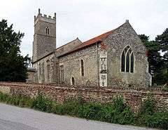 St Thomas, Foxley | |
 Foxley Foxley shown within Norfolk | |
| Area | 6.66 km2 (2.57 sq mi) |
| Population | 285 (2011)[1] |
| • Density | 43/km2 (110/sq mi) |
| OS grid reference | TG039218 |
| Civil parish |
|
| District | |
| Shire county | |
| Region | |
| Country | England |
| Sovereign state | United Kingdom |
| Post town | DEREHAM |
| Postcode district | NR20 |
| Police | Norfolk |
| Fire | Norfolk |
| Ambulance | East of England |
| EU Parliament | East of England |
Foxley is a village and civil parish in the English county of Norfolk. The village is about 15 miles (24 km) north-west of Norwich and 9 miles (14 km) south-east of Fakenham. It covers an area of 6.66 km2 (2.57 sq mi) and had a population of 279 in 113 households at the 2001 census,[2] increasing slightly to a population of 285 in 125 households at the 2011 Census. For the purposes of local government, it falls within the Upper Wensum Ward of Breckland District Council and the Elmham and Mattishall Division of Norfolk County Council.
The village is effectively divided into East and West Foxley by the A1067 road that was built as a bypass of it and the nearby village of Bawdeswell.
Foxley Wood, close by, is a site of special scientific interest and the largest remaining area of ancient woodland in Norfolk, England. It is thought to be over 6000 years old dating from the end of the last ice age.[3]
Notes
- ↑ "Civil Parish population 2011". Neighbourhood Statistics. Office for National Statistics. Retrieved 4 August 2016.
- ↑ Census population and household counts for unparished urban areas and all parishes. Office for National Statistics & Norfolk County Council (2001). Retrieved 20 June 2009.
- ↑ "Foxley Wood National Nature Reserve" (PDF). Natural England. Archived from the original (PDF) on 11 January 2011. Retrieved 31 December 2010.
External links
![]()