Besthorpe, Norfolk
| Besthorpe | |
|---|---|
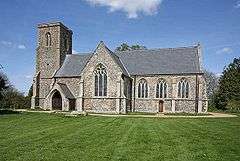 All Saints Church, Besthorpe | |
 Besthorpe Besthorpe shown within Norfolk | |
| Area | 8.87 km2 (3.42 sq mi) |
| Population |
561 (2001 census)[1] 778 (2011)[2] |
| • Density | 63/km2 (160/sq mi) |
| OS grid reference | TM058953 |
| Civil parish |
|
| District | |
| Shire county | |
| Region | |
| Country | England |
| Sovereign state | United Kingdom |
| Post town | ATTLEBOROUGH |
| Postcode district | NR17 |
| Police | Norfolk |
| Fire | Norfolk |
| Ambulance | East of England |
| EU Parliament | East of England |
Besthorpe is a village and civil parish in the Breckland district of Norfolk, England, about a mile east of Attleborough, on the A11 road. According to the 2001 census it had a population of 561,[1] increasing to 778 at the 2011 Census.[2]
The village school has long been closed and is now a private dwelling. The church is located in a remote part of the parish, giving rise to the belief that plague, the Black Death, once decimated the original community, resulting in the destruction of many local dwellings. Although no factual evidence exists to support this theory, the plague hit Norfolk very badly.
The village possesses two halls; the Old Hall and New Hall. The Old Hall is located close to Burgh Common and was also known as Plassing Hall. For many years it was a farm but has recently been converted into a private dwelling. It still possesses a section of moat and some original stained glass.
New Hall was built between 1560 and 1593 by the family of Robert Drury (c.1456-1535), who gave his name to Drury Lane in London. One of the daughters from this family was rumoured to have been drowned in the lake at Lord Byron's family home, Newstead Abbey. Reference books on ghost stories claim that she was murdered along with a coachman with whom she formed a relationship; a 'phantom coach' is said to haunt the Abbey. The Hall possesses one of the few surviving 'tilting grounds' in England; tilting grounds were used for jousting by medieval knights.
Somewhat notoriously, the village possesses a road known as Sluts Hole Lane, although this is most likely a spelling mistake made by late Victorian census takers which has passed into relatively modern usage (maps and census documents held in Norwich's Library, 'The Forum', show it was originally known as Slutch Hole Lane). Attempts to restore the original name have been opposed by local historians; a residents' petition for a change was resisted in 1999.[3] Slutch is an old English word meaning 'slushy' or 'muddy'; an alternative etymology is that it comes from the Dutch word for 'sluice', used in draining the fens.[3]
References
- 1 2 Census population and household counts for unparished urban areas and all parishes. Office for National Statistics & Norfolk County Council (2001). Retrieved 20 June 2009.
- 1 2 "Civil Parish population 2011". Neighbourhood Statistics. Office for National Statistics. Retrieved 29 July 2016.
- 1 2 Wainwright, Martin (12 February 2000). "Street name chimes with its station". The Guardian. Retrieved 26 July 2017.
External links
| Wikimedia Commons has media related to Besthorpe, Norfolk. |