Wells-next-the-Sea
| Wells-next-the-Sea | |
|---|---|
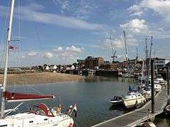 The quayside | |
 Wells-next-the-Sea Wells-next-the-Sea shown within Norfolk | |
| Area | 16.31 km2 (6.30 sq mi) |
| Population | 2,165 (2011 Census) |
| • Density | 133/km2 (340/sq mi) |
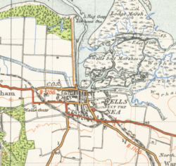
| OS grid reference | TF 914 430 |
| District | |
| Shire county | |
| Region | |
| Country | England |
| Sovereign state | United Kingdom |
| Post town | WELLS-NEXT-THE-SEA |
| Postcode district | NR23 |
| Dialling code | 01328 |
| Police | Norfolk |
| Fire | Norfolk |
| Ambulance | East of England |
| EU Parliament | East of England |
| UK Parliament | |
Wells-next-the-Sea is a port on the North Norfolk coast of England.
The civil parish has an area of 16.31 km2 (6.30 sq mi) and in 2001 had a population of 2,451,[1] reducing to 2,165 at the 2011 Census.[2]
Wells is 15 miles (24 km) to the east of the resort of Hunstanton, 20 miles (32 km) to the west of Cromer, and 10 miles (16 km) north of Fakenham. The city of Norwich lies 32 miles (51 km) to the south-east. Nearby villages include Blakeney, Burnham Market, Burnham Thorpe, Holkham and Walsingham.[3]
Origin of name
The name is Guella in the Domesday Book (half gallicised, half Latinised from Anglian Wella, a spring). This derives from spring wells of which Wells used to have many, rising through the chalk of the area. The town started to be known as Wells-next-the-Sea in the early 19th century to distinguish it from other places of the same name. When the Wells and Fakenham Railway was opened on 1 December 1857, the terminus was given the name of "Wells-on-Sea". In 1956 the Wells Urban District Council voted to (re-)adopt the name Wells-next-the-Sea, and this has been the official name since then.[4]
Geography
The North Sea is now a mile from the town, as a result of the silting of the harbour. The Holkham Estate reclaimed some 800 hectares of saltmarsh north-west of Wells, completed by the construction of a mile-long sea-wall in 1859.[5] This reclamation reduced the tidal scour and is itself a further cause of silting. The town has long thrived as a seaport and is now also a seaside resort with a popular beach that can be reached on foot or by a narrow gauge railway that runs partway alongside the mile-long sea wall north of the harbour. The beach is known for its long flat terrain, abstract sand dunes, varied unique beach huts and a naturist area situated to the west at Holkham. A land-locked brackish pool called Abraham's Bosom is used for pleasure boating and canoeing. The beach is backed by dense pine woods which are part of the Holkham National Nature Reserve. The woods comprise Scots pine, Maritime pine and Corsican Pine growing on sand.[6]
More pinewoods exist to the east of the beach over the shipping channel at an area called the East Hills. This can be accessed on foot at low tide though all of the tidal sands in the area are extremely dangerous due to the speed and currents of the rising tide. It is not advisable to cross the channel without detailed local knowledge.
The town stretches nearly a mile inland. The majority of shops and other such businesses are now found on Staithe Street but up to the 1960s commercial premises were also to be found along High Street which continues south towards St Nicholas's Church. The church burned after a lightning strike in 1879: the exterior shows the original stonework, but the interior is sparse and lacks interest. John Fryer, Captain Bligh's sailing master on HMS Bounty was born at Wells, and is buried in the churchyard.
The distinctive landmark of the seafront is the granary with its overhanging gantry on the quay, started in 1902 and finished in 1904. This has now been converted into flats, having ceased operating as a granary in 1990. The maritime tradition of the town meant it used to have a remarkable number of public houses for a town of its size although many of these have since closed. The northern end of the town used to be notable for parallel "yards", narrow rows of cottages similar to the northern "ginnels", which could be relics of Danish occupation. These were largely lost in the terrible 1953 flood damage, and subsequent "slum clearance". The 1953 flood affected the northern edge of the town as well as destroying the pine forest which had fringed Abraham's Bosom. Today there is a large moving flood gate next to the harbour car park and many of the houses have their own flood defences.
A feature of the town is the area known as The Buttlands, a large green ringed by lime trees. Large elegant Georgian houses overlook The Buttlands, as do the Crown Hotel, Globe Inn and the Wells Catholic Church. If you exit The Buttlands down the hill at its south-west corner you can see Ware Hall, which was rebuilt over a period of years from the 1970s by Miss May Savidge, who brought it in parts when she moved from Ware in Hertfordshire.[7] It was a significant port in the sixteenth century with 19 ships over 16 tons burden operating out of Wells in 1580, making it the major port in the area: the main trade was corn.[8]
Transport
Railways
Formerly the town was served by Wells-on-Sea railway station and was connected to the British Rail network by two lines. The line westwards towards King's Lynn was never reinstated after damage in the 1953 East Coast Floods, while the line to Norwich via Fakenham, Dereham and Wymondham was a victim of the "Beeching Axe" of the 1960s. The Wells and Walsingham Light Railway, a 10¼ inch-gauge railway (the longest of such a gauge in the world), now uses part of the track-bed and has its own separate Wells railway station.[9]
The Wells Harbour Railway[10] is a separate 10¼ inch-gauge railway that takes passengers from the harbour behind the sea wall towards the beach and caravan site.
Near the centre of the town is the former Wells County Primary School (linked by School Lane from High Street). The junior school was relocated to the former Secondary Modern school when a new secondary school, Alderman Peel High School, was built in the late 1960s, part of which is upon the former railway line to the west towards King's Lynn. For several years, these buildings housed a field studies centre. More recently, though, the former school has been converted to social housing units.
Buses
Wells-next-the-Sea is located on the high-profile Coasthopper bus service between King's Lynn and Cromer, operated by Stagecoach in Norfolk. Additional services are provided by Lynx and Sanders Coaches.
In April 2018, Stagecoach will be ceasing operations in Norfolk. The Coasthopper service will be split into two sections at Wells-next-the-Sea: the section from King's Lynn to Wells will be rebranded as the Coastliner 36, extended inland from Wells to Fakenham, and taken over by Lynx; while the section from Wells to Cromer will be rebranded as the 4 and taken over by Sanders Coaches.
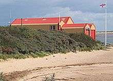
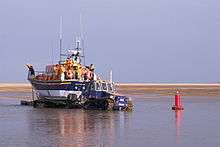
Lifeboat
The current lifeboat station, housing both an all-weather lifeboat and an inshore rescue boat, is at the harbour entrance. The old lifeboat house, now used as the harbour offices, is at the western end of the quay
In 1880, Wells was the scene of a lifeboat disaster in which 11 of the 13 lifeboat crew drowned, leaving 10 widows and 27 children without fathers. A memorial to the crew stands adjacent to the old lifeboat house.
Education
Schools in the town include Wells-Next-The-Sea Primary and Nursery School and Alderman Peel High School.[11][12]
Beach
The Wells-next-the-Sea beach, being subject to the ever-changing tides of Holkham National Nature Reserve, makes use of an old war siren to warn patrons of incoming beach floodings. The siren sounds around 5–10 minutes before the tide is predicted to take over the beach to allow users to vacate the area safely.
Storms
Prime Minister, David Cameron, visited the town on 9 December 2013 to inspect the damage created by a storm surge. Numerous homes and businesses were affected by the highest tide recorded in the town on 5 December 2013.[13]
Gallery
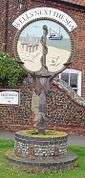 Signpost in Wells-next-the-Sea
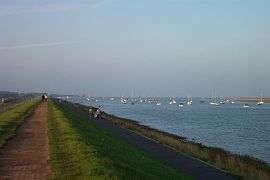 The harbour mouth from the sea wall; the lifeboat house can be seen in the distance.
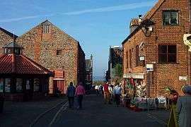 Inland Wells, with view to Wells Harbour.
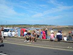 Looking out to the quay on a sunny August 2006 day.
 The train from Wells arrives at Walsingham station
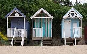 Huts on the beach
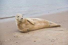 Grey seal on the beach
References
- ↑ Office for National Statistics & Norfolk County Council (2001). Census population and household counts for unparished urban areas and all parishes Archived 11 February 2017 at the Wayback Machine.. Retrieved 2 December 2005.
- ↑ "Town population 2011". Retrieved 1 September 2015.
- ↑ Ordnance Survey (2002). OS Explorer Map 251 – Norfolk Coast Central. ISBN 0-319-21887-2.
- ↑ Description of Wells-next-the-Sea www.wellsnextthesea.info/Wellsonsea/WellsWeb/desc.html. Retrieved 28 November 2011.
- ↑ Nature Reserve : The Beach : Holkham Hall and Estate – North Norfolk, England www.holkham.co.uk/html/nature_reserve.html Archived 15 December 2014 at the Wayback Machine.
- ↑ Holkham National Nature Reserve holkham.co.uk/naturereserve/
- ↑ The house that May built, Eastern Daily Press, 28 November 2007
- ↑ Pooley, Graham (1992). The Port of Wells: 1100 Years of History. ISBN 978-0-9516120-1-9.
- ↑ Wellswalsinghamrailway.co.uk
- ↑ Wellsharbourrailway.co.uk
- ↑ Coulson, Tim (10 May 2016). "Warning notice to Wells-Next-The-Sea Primary and Nursery School". Gov.UK. Gov.UK. Retrieved 1 October 2018.
- ↑ "Alderman Peel High School". Find and compare schools in England. Gov.UK. Retrieved 1 October 2018.
- ↑ BBC news report Retrieved 10 December 2013
External links
| Wikivoyage has a travel guide for Wells-next-the-Sea. |
| Wikimedia Commons has media related to Wells-next-the-Sea. |
- Alderman Peel High School
- Wells web cam
- Wells Next Sea Local Portal
- Map sources for Wells-next-the-Sea
- Tide tables for Wells-next-the-Sea.
- Photographs more details and interesting facts about Wells-next-the-Sea
- Wells Norfolk Online
- Gallery of Wells-next-the-Sea – Photographs of Wells-next-the-Sea