South Cambridgeshire
| South Cambridgeshire District | |
|---|---|
| Non-metropolitan district | |
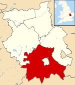 South Cambridgeshire shown within Cambridgeshire | |
| Sovereign state | United Kingdom |
| Constituent country | England |
| Region | East of England |
| Non-metropolitan county | Cambridgeshire |
| Status | Non-metropolitan district |
| Admin HQ | Cambourne |
| Incorporated | 1 April 1974 |
| Government | |
| • Type | Non-metropolitan district council |
| • Body | South Cambridgeshire District Council |
| • Leadership | Leader & Cabinet (Liberal Democrat) |
| • MPs |
Heidi Allen (C) Lucy Frazer (C) |
| Area | |
| • Total | 348.12 sq mi (901.63 km2) |
| Area rank | 37th (of 326) |
| Population (mid-2017 est.) | |
| • Total | 156,700 |
| • Rank | 123rd (of 326) |
| • Density | 450/sq mi (170/km2) |
| • Ethnicity | 97.1% White |
| Time zone | UTC0 (GMT) |
| • Summer (DST) | UTC+1 (BST) |
| ONS code |
12UG (ONS) E07000012 (GSS) |
| OS grid reference | TL318598 |
| Website |
www |
South Cambridgeshire is a mostly rural local government district of Cambridgeshire, England with a population of 148,755 at the 2011 Census.[1] It was formed on 1 April 1974 by the merger of Chesterton Rural District and South Cambridgeshire Rural District. It completely surrounds the city of Cambridge, which is administered separately from the district by Cambridge City Council.
Southern Cambridgeshire, including both the district of South Cambridgeshire and the city of Cambridge, has a population of over 281,000 (including students) and an area of 1,017.28 km square.
On the abolition of South Herefordshire and Hereford districts to form the unitary Herefordshire in 1998, South Cambridgeshire remained the only English district to completely encircle another. As the other parts of Britain consists of district-equivalents, none of them are shaped like a doughnut.
The district's coat of arms contains a reference to the coat of arms of Cambridge University. The motto, Niet Zonder Arbyt, means "Not Without Work" in old Dutch; it was originally the motto of Cornelius Vermuyden who drained The Fens in the 17th century. The district council's headquarters moved from Cambridge to Cambourne in 2004.
South Cambridgeshire has scored highly on the best places to live, according to Channel 4, which ranked South Cambridgeshire as the fifth best place to live in 2006. A Halifax survey rated South Cambridgeshire the best place to live in rural Britain.
List of settlements
Abington Piggotts – Arrington – Babraham – Balsham – Bar Hill – Barrington – Bartlow – Barton – Bassingbourn cum Kneesworth – Bourn – Boxworth – Caldecote – Cambourne – Carlton – Castle Camps – Caxton – Childerley – Chishills – Chittering – Comberton – Conington – Coton – Cottenham – Croxton – Croydon – Dry Drayton – Duxford – Elsworth – Eltisley – Fen Ditton – Fen Drayton – Fowlmere – Foxton – Fulbourn – Gamlingay – Girton – Grantchester – Graveley – Great Abington – Great Eversden – Great Shelford – Great Wilbraham – Guilden Morden – Hardwick – Harlton – Harston – Haslingfield – Hatley – Hauxton – Heydon – Hildersham – Hinxton – Histon – Horseheath – Horningsea – Ickleton – Impington – Kingston – Knapwell – Landbeach – Linton – Litlington – Little Abington – Little Eversden – Little Gransden – Little Shelford – Little Wilbraham – Lolworth – Longstanton – Longstowe – Madingley – Melbourn – Meldreth – Milton – Newton – Oakington – Orchard Park – Orwell – Over – Pampisford – Papworth Everard – Papworth St Agnes – Rampton – Sawston – Shepreth – Shingay cum Wendy – Shudy Camps – Six Mile Bottom – Stapleford – Steeple Morden – Stow-cum-Quy – Swavesey – Tadlow – Teversham – Thriplow & Heathfield – Toft – Waterbeach – West Wickham – West Wratting – Weston Colville – Westwick – Whaddon – Whittlesford – Willingham – Wimpole
Local government
South Cambridgeshire District Council's headquarters are located in South Cambridgeshire Hall in the Cambourne Business Park in Cambourne.[2] The council consists of 45 councillors (reduced from 57 in 2018), representing 26 electoral wards (reduced from 34 in 2018). The Liberal Democrats now have a strong majority on the council, having gained control in the 2018 local elections which saw a major shift in voting; the Conservatives having had control since 2007. Prior to that, no party had overall control of the council.
| Party | Councillors |
|---|---|
| Liberal Democrat | 30 |
| Conservative | 11 |
| Independent | 2 |
| Labour | 2 |
Transportation
Cambridge Airport is located in South Cambridgeshire.[3]
The Cambridgeshire Guided Busway passes through South Cambridgeshire.
Economy
ScotAirways has its head office on the grounds of Cambridge Airport in South Cambridgeshire.[3][4]
References
- ↑ "Non Metropoliatan District council population 2011". Neighbourhood Statistics. Office for National Statistics. Retrieved 13 July 2016.
- ↑ "How to find us Archived 23 October 2010 at the Wayback Machine.." South Cambridgeshire. Retrieved on 6 June 2010.
- 1 2 "Local Plan 2004 map 27b – Cambridge Airport." South Cambridgeshire District Council. Retrieved on 6 July 2010.
- ↑ "Contact Us." ScotAirways. Retrieved on 29 September 2009.
External links
| Unitary authorities | |
|---|---|
| Boroughs or districts | |
| Major settlements | |
| Rivers | |
| Topics |
|
Districts of the East of England | ||
|---|---|---|
| Bedfordshire |  | |
| Cambridgeshire | ||
| Essex | ||
| Hertfordshire | ||
| Norfolk | ||
| Suffolk |
| |