Sporle with Palgrave
| Sporle with Palgrave | |
|---|---|
 Sporle with Palgrave Sporle with Palgrave shown within Norfolk | |
| Area | 17.21 km2 (6.64 sq mi) |
| Population | 1,011 (2011 census)[1] |
| • Density | 59/km2 (150/sq mi) |
| OS grid reference | TF848113 |
| Civil parish |
|
| District | |
| Shire county | |
| Region | |
| Country | England |
| Sovereign state | United Kingdom |
| Post town | KING'S LYNN |
| Postcode district | PE32 |
| Police | Norfolk |
| Fire | Norfolk |
| Ambulance | East of England |
| EU Parliament | East of England |
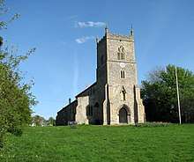
St Mary's church in Sporle
Sporle with Palgrave is a civil parish in the English county of Norfolk. It covers an area of 17.21 km2 (6.64 sq mi) and had a population of 1,038 in 442 households at the 2001 census,[2] including East Lexham but the population reducing to 1,011 in 453 households at the 2011 Census. For the purposes of local government, it falls within the district of Breckland.
The village
The village has a church, St Mary's, and is also served by a village shop and a pub called The Squirrel's Drey. There are active book clubs and a bus service. There is a new primary school and a separate community centre in the former primary school.
Notes
| Wikimedia Commons has media related to Sporle with Palgrave. |
- ↑ "Civil Parish population 2011". Neighbourhood Statistics. Office for National Statistics. Retrieved 3 August 2016.
- ↑ Census population and household counts for unparished urban areas and all parishes Archived 2017-02-11 at the Wayback Machine.. Office for National Statistics & Norfolk County Council (2001). Retrieved 20 June 2009.
This article is issued from
Wikipedia.
The text is licensed under Creative Commons - Attribution - Sharealike.
Additional terms may apply for the media files.