Wayland Rural District
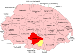 Boundaries in 1894. 1902 extension in yellow |
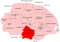 Boundaries in 1935 |
Wayland Rural District was a rural district in Norfolk, England from 1894 to 1974.[1]
It was formed under the Local Government Act 1894 based on the Wayland rural sanitary district, taking its name from the ancient Wayland hundred. It lay in the central southern part of the county.
In 1902 it took in the northern part of the disbanded Guiltcross Rural District,[2] and in 1935 the eastern section of the disbanded Thetford Rural District (much of which had also been transferred from Guiltcross RD).
In 1974, the district was abolished under the Local Government Act 1972, and became part of the Breckland district.
Statistics
| Year | Area (ha) [3] |
Population [4] |
Density (pop/ha) |
|---|---|---|---|
| 1911 | 27,832 | 14,425 | 0.52 |
| 1921 | 13,121 | 0.47 | |
| 1931 | 13,150 | 0.47 | |
| 1951 | 43,254 | 20,643 | 0.48 |
| 1961 | 19,413 | 0.45 |
Parishes
| Parish | From | To | Notes |
|---|---|---|---|
| Attleborough | |||
| Banham | 1902 | Formerly Guiltcross RD | |
| Besthorpe | |||
| Blo' Norton | 1935 | Formerly Thetford RD (ex Guiltcross RD) | |
| Breckles | 1935 | Added to Stow Bedon | |
| Brettenham | 1935 | Formerly Thetford RD | |
| Bridgham | 1935 | Formerly Thetford RD (ex Guiltcross RD) | |
| Carbrooke | |||
| Caston | |||
| Croxton | 1935 | Formerly Thetford RD | |
| Garboldisham | 1935 | Formerly Thetford RD (ex Guiltcross RD) | |
| Great Ellingham | |||
| Griston | |||
| Hargham | 1935 | Added to Quidenham | |
| Harling | Merger of East Harling and West Harling (from Thetford RD, ex Guiltcross RD) | ||
| Hockham | |||
| Illington | 1935 | Added to Wretham | |
| Kenninghall | 1902 | Formerly Guiltcross RD | |
| Kilverstone | 1935 | Formerly Thetford RD | |
| Larling | 1935 | Added to Roudham | |
| Little Ellingham | |||
| Merton | |||
| New Buckenham | 1902 | Formerly Guiltcross RD | |
| North Lopham | 1935 | Formerly Thetford RD (ex Guiltcross RD) | |
| Old Buckenham | 1902 | Formerly Guiltcross RD | |
| Ovington | |||
| Quidenham | 1902 | Formerly Guiltcross RD | |
| Riddlesworth | 1935 | Formerly Thetford RD (ex Guiltcross RD) | |
| Rocklands | 1935 | Merger of next 2 parishes | |
| Rockland All Saints and St Andrew | 1935 | ||
| Rockland St Peter | 1935 | ||
| Roudham | |||
| Scoulton | |||
| Shropham | |||
| Snetterton | |||
| South Lopham | 1935 | Formerly Thetford RD (ex Guiltcross RD) | |
| Stow Bedon | |||
| Thompson | |||
| Tottington | |||
| Watton | |||
| Wilby | 1902 | 1935 | Formerly Guiltcross RD. Added to Quidenham |
| Wretham | 1935 | Formerly Thetford RD |
References
- ↑ "Wayland RD through time: Census tables with data for the Local Government District". A Vision of Britain through Time. GB Historical GIS / University of Portsmouth. Retrieved 29 June 2017.
- ↑ "Kenninghall CP/AP through time: Census tables with data for the Parish-level Unit". A Vision of Britain through Time. GB Historical GIS / University of Portsmouth. This change is not reported on the District level pages, but is apparent from parish commencement dates. Retrieved 29 June 2017.
- ↑ "Wayland RD through time: Population Statistics: Area (acres)". A Vision of Britain through Time. GB Historical GIS / University of Portsmouth. Retrieved 29 Jun 2017.
- ↑ "Wayland RD through time: Population Statistics: Total Population". A Vision of Britain through Time. GB Historical GIS / University of Portsmouth. Retrieved 29 Jun 2017.
This article is issued from
Wikipedia.
The text is licensed under Creative Commons - Attribution - Sharealike.
Additional terms may apply for the media files.