North Sutton, New Hampshire
| North Sutton, New Hampshire | |
|---|---|
| Unincorporated community | |
 | |
 North Sutton  North Sutton | |
| Coordinates: 43°21′50″N 71°56′22″W / 43.36389°N 71.93944°WCoordinates: 43°21′50″N 71°56′22″W / 43.36389°N 71.93944°W | |
| Country | United States |
| State | New Hampshire |
| County | Merrimack |
| Town | Sutton |
| Elevation | 915 ft (279 m) |
| Time zone | UTC-5 (Eastern (EST)) |
| • Summer (DST) | UTC-4 (EDT) |
| ZIP code | 03260 |
| Area code(s) | 603 |
| GNIS feature ID | 868818[1] |
North Sutton is an unincorporated community in the town of Sutton in Merrimack County, New Hampshire. It is located at the eastern end of Kezar Lake, adjacent to Wadleigh State Park.
New Hampshire Route 114 passes through the village, leading north to New London and south to Sutton Village, South Sutton, and Bradford. Interstate 89 passes just east of the village, which can be accessed from Exit 10.
North Sutton has a separate ZIP code (03260) from other parts of the town of Sutton.
References
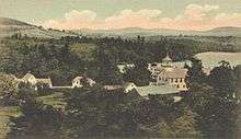
View of North Sutton c. 1905
Municipalities and communities of Merrimack County, New Hampshire, United States | ||
|---|---|---|
| Cities | 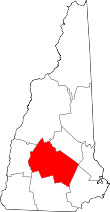 | |
| Towns | ||
| CDPs | ||
| Other unincorporated communities | ||
| Footnotes | ‡This populated place also has portions in an adjacent county or counties | |
This article is issued from
Wikipedia.
The text is licensed under Creative Commons - Attribution - Sharealike.
Additional terms may apply for the media files.