Alfredtown
| Alfredtown New South Wales | |
|---|---|
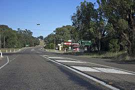 Sturt Highway in Alfredtown | |
|
Alfredtown | |
| Coordinates | 35°10′0″S 147°31′0″E / 35.16667°S 147.51667°ECoordinates: 35°10′0″S 147°31′0″E / 35.16667°S 147.51667°E |
| Population | 109 (2016 census)[1] |
| Postcode(s) | 2650 |
| Elevation | 195 m (640 ft) |
| Location |
|
| LGA(s) | City of Wagga Wagga |
| County | Wynyard |
| Parish | Cunningdroo |
| State electorate(s) | Wagga Wagga |
| Federal Division(s) | Riverina |
Alfredtown (known as Alfred Town [3] until 1988, and previously known as The Shanty) is a rural community in the central east part of the Riverina.[3] It is about 5 km north of Ladysmith and 14 km east of Wagga Wagga.
Alfredtown is on the Sturt Highway and consists of The Shanty Hotel (otherwise known as The Shanty Tavern & Bistro) and a petrol station combined with small store.
Notes and references
- ↑ Australian Bureau of Statistics (27 June 2017). "Alfredtown (State Suburb)". 2016 Census QuickStats. Retrieved 27 June 2017.

- ↑ Travelmate Archived March 25, 2007, at the Wayback Machine.
- 1 2 "Alfredtown". Geographical Names Register (GNR) of NSW. Geographical Names Board of New South Wales. Retrieved 1 August 2013.
External links
![]()
This article is issued from
Wikipedia.
The text is licensed under Creative Commons - Attribution - Sharealike.
Additional terms may apply for the media files.