Bergamasque Alps and Prealps
| Bergamasque Alps and Prealps | |
|---|---|
| Alpi e Prealpi Bergamasche | |
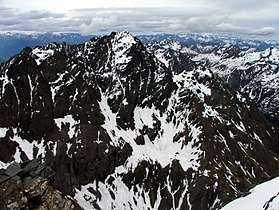 Pizzo Coca - view from Pizzo Redorta | |
| Highest point | |
| Peak | Pizzo Coca |
| Elevation | 3,050 m (10,010 ft) |
| Coordinates | 46°47′10″N 10°00′42″E / 46.78611°N 10.01167°ECoordinates: 46°47′10″N 10°00′42″E / 46.78611°N 10.01167°E |
| Geography | |
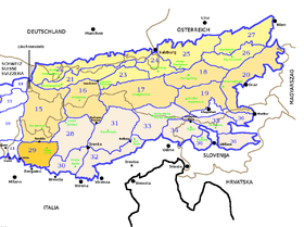 Bergamasque Alps and Prealps (section nr.29) within Eastern Alps
| |
| Country | Italy |
| Region | Lombardy |
| Province | Bergamo, Sondrio, Lecco, Brescia |
| Parent range | Alps |
| Borders on | |
| Geology | |
| Orogeny | Alpine orogeny |
| Type of rock | Sedimentary rocks, especially in the southernmost area[1] |
The Bergamasque Alps and Prealps (Alpi e Prealpi Bergamasche in Italian) are a mountain range in the southern part of the Alps. They are located in Lombardy, in the northern part of Italy.
Geography
Administratively the range belongs to the Italian province of Bergamo and, marginally, to the provinces of Sondrio, Lecco and Brescia.
The western slopes of the mountains are drained by the Adda, the central and western part of the range by Oglio and other minor rivers and streams, all of them tributaries of the Po .
SOIUSA classification
According to SOIUSA (International Standardized Mountain Subdivision of the Alps) the mountain range is an Alpine section, classified in the following way:[2]
- main part = Eastern Alps
- major sector = Southern Limestone Alps
- section = Bergamasque Alps and Prealps
- code = II/C-29
Borders
Bergamasque Alps and Prealps' borders are (clockwise):
- Como lake (west);
- river Adda, Aprica pass and Corteno valley (north);
- val Camonica and Iseo lake (east);
- Po Plain (south).
Subdivision
The Bergamasque Alps and Prealps are subdivided in two subsections:[2]
- Bergamo Alps (IT: Alpi Orobie) - SOIUSA code: II/C-29.I,
- Bergamasque Prealps (IT: Prealpi Bergamasche)- SOIUSA code: II/C-29.II,
which are divided by some secondary valleys of Val Brembana, Val Seriana and Val Camonica: Valsassina, Valtorta, Val Secca, Valcanale, Val Nembo, Val di Scalve and Val Paisco.
Notable summits

Some notable summits of the range are:
| Name | metres | feet |
|---|---|---|
| Pizzo Coca | 3,050 | 10,007 |
| Corno Stella | 2,620 | 8,596 |
| Pizzo Recastello | 2,886 | 9,475 |
| Monte Legnone | 2,609 | 8,563 |
| Pizzo Tre Signori | 2,554 | 8,379 |
| Pizzo Arera | 2,512 | 8,241 |
| Presolana | 2,511 | 8,239 |
| Pizzo Camino | 2,492 | 8,224 |
| Grigna | 2,410 | 7,907 |
| Monte Resegone | 1,875 | 6,155 |
| Canto Alto | 1,146 | 3,760 |
References
- ↑ VV. AA. (2002). Bergamo e provincia (in Italian). Touring Club Italiano. p. 19.
- 1 2 Marazzi, Sergio (2005). Atlante Orografico delle Alpi. SOIUSA (in Italian). Priuli & Verlucca. ISBN 978-88-8068-273-8.
Maps
- Italian official cartography (Istituto Geografico Militare - IGM); on-line version: www.pcn.minambiente.it
| Western Alps |
| ||||||
|---|---|---|---|---|---|---|---|
| Eastern Alps |
| ||||||
| History |
|  | ||||
|---|---|---|---|---|---|---|
| Geography | ||||||
| Politics | ||||||
| Economy | ||||||
| Society |
| |||||