Carnic and Gailtal Alps
| Carnic and Gailtal Alps | |
|---|---|
|
Italian: Alpi Carniche e della Gail German: Karnische und Gailtaler Alpen | |
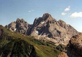 Hohe Warte/ Monte Coglians, the highest summit of the range, on the right, and Kellerspitzen on the left, viewed from the northwest. | |
| Highest point | |
| Peak | Coglians |
| Elevation | 2,780 m (9,120 ft) |
| Coordinates | 46°36′25″N 12°52′56″E / 46.60694°N 12.88222°ECoordinates: 46°36′25″N 12°52′56″E / 46.60694°N 12.88222°E |
| Geography | |
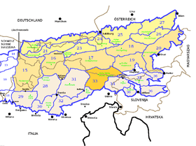 Carnic and Gailtal Alps (33) within the Eastern Alps
| |
| Countries | Austria and Italy |
| States | Tyrol, Carinthia and Friuli-Venezia Giulia |
| Parent range | Southern Limestone Alps |
| Borders on | |
| Geology | |
| Orogeny | Alpine orogeny |
The Carnic and Gailtal Alps (Italian: Alpi Carniche e della Gail, German: Karnische und Gailtaler Alpen) is a geographic grouping of mountain ranges belonging to the Southern Limestone Alps. They are located in Austria and Italy.
Geography
The range is bound by the Drau River in the north, separating it from the Western Tauern section of the Central Eastern Alps. The northern, entirely Austrian range is called the Gailtal Alps or Drauzug, bordered by the Gail River in the south. The Gail Valley is on the Periadriatic Seam, so that from a tectonic perspective the Gailtal Alps belong to the Central Eastern Alps. The Gailtal Alps are divided by the very deep Gailbergsattel (981 m) into a higher western section called the Lienzer Dolomites and a lower eastern section, to which the name Gailtal Alps is sometimes restricted. Passes in the eastern section include the Kreuzbergsattel and Windische Höhe.
The main ridge of the Carnic Alps forms the Austrian-Italian border and stretches from prominent Mt. Helm near Sexten at the tripoint of East Tyrol, South Tyrol and Veneto to the Canal Valley at Tarvisio in the east. It includes several peaks reaching nearly 2,800 m (9,200 ft) as well as the Plöcken and Naßfeld passes.
In the south the Carnic Prealps stretch between the Piave and Tagliamento rivers down to the Padan Plain.
Administratively the range is divided between the Italian Region of Friuli-Venezia Giulia, and the Austrian states Tyrol and Carinthia.
SOIUSA classification
According to SOIUSA (International Standardized Mountain Subdivision of the Alps) the Carnic and Gailtal Alps are an Alpine section, classified in the following way:[1]
- main part = Eastern Alps
- major sector = Southern Limestone Alps
- section = Carnic and Gailtal Alps
- code = II/C-33
Subdivision
The Carnic and Gailtal Alps are divided into three subsections:
- Carnic Alps (IT: Alpi Carniche; DE: Karnischer Hauptkamm) - SOIUSA code:II/C-33.I;
- Gailtal Alps (DE: Gailtaler Alpen or Drauzug) - SOIUSA code:II/C-33.II;
- Carnic Prealps (IT: Prealpi Carniche) - SOIUSA code:II/C-33.III.
Notable summits

Some notable summits of the range are:
| Name | metres | subsection |
|---|---|---|
| Coglians / Hohe Warte | 2,782 | Carnic Alps |
| Kellerspitzen / Creta delle Chianevate | 2,774 | Carnic Alps |
| Große Sandspitze | 2,770 | Lienzer Dolomites |
| Spitzkofel | 2,717 | Lienzer Dolomites |
| Cima dei Preti | 2,703 | Carnic Prealps |
| Monte Peralba | 2,694 | Carnic Alps |
| Monte Cavallino / Große Kinigat | 2,689 | Carnic Alps |
| Hochstadel | 2,681 | Lienzer Dolomites |
| Monte Duranno | 2,668 | Carnic Prealps |
| Rosskopf | 2,603 | Carnic Alps |
| Zwölferspitz | 2,592 | Carnic Alps |
| Eggenkofel | 2,591 | Lienzer Dolomites |
| Monte Terza Grande | 2,586 | Carnic Alps |
| Monte Cridola | 2,581 | Carnic Prealps |
| Hochspitz | 2,581 | Carnic Alps |
| Torrione dei Longerin | 2,571 | Carnic Alps |
| Wolayer Seekopf | 2,551 | Carnic Alps |
| Monte Brentoni | 2,548 | Carnic Alps |
| Cima Monfalcon di Montanaia | 2,548 | Carnic Prealps |
| Gamskofel | 2,526 | Carnic Alps |
| Steinwand | 2,520 | Carnic Alps |
| Monte Chiadenis | 2,459 | Carnic Prealps |
| Gamswiesenspitze | 2,486 | Lienzer Dolomites |
| Helm | 2,434 | Carnic Alps |
| Reißkofel | 2,371 | Gailtal Alps |
| Lumkofel | 2,287 | Gailtal Alps |
| Trogkofel / Creta di Aip | 2,195 | Carnic Alps |
| Jauken | 2,276 | Gailtal Alps |
| Gartnerkofel | 2,195 | Carnic Alps |
| Dobratsch | 2,166 | Gailtal Alps (Villach Alps) |
References
| Western Alps |
| ||||||
|---|---|---|---|---|---|---|---|
| Eastern Alps |
| ||||||