Northern Styrian Alps
| Northern Styrian Alps | |
|---|---|
|
Steirische Nordalpen | |
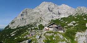 The Hochtor, in the foreground the Hesshütte | |
| Highest point | |
| Peak | Hochtor |
| Elevation | 2,369 m (7,772 ft) |
| Coordinates | 47°33′44″N 14°38′01″E / 47.56222°N 14.63361°ECoordinates: 47°33′44″N 14°38′01″E / 47.56222°N 14.63361°E |
| Geography | |
 Northern Styrian Alps (section nr.26) within Eaestern Alps
| |
| Country | Austria |
| States of Austria | Styria, Upper Austria and Lower Austria |
| Parent range | Alps |
| Borders on | Styrian Prealps, Eastern Tauern Alps, Salzkammergut and Upper Austria Alps and Northern Lower Austria Alps |
| Geology | |
| Orogeny | Alpine orogeny |
| Type of rock | Sedimentary rocks[1] |
The Northern Styrian Alps (Steirische Nordalpen in German) is the proposed name for a subdivision of mountain ranges in an as-yet-unadopted classification of the Alps located in Austria.
Geography
Administratively the range belongs to the Austrian state of Styria and, marginally, to Upper Austria and Lower Austria. The whole range is drained by the Danube river.
SOIUSA classification
According to SOIUSA (International Standardized Mountain Subdivision of the Alps) the mountain range is an Alpine section, classified in the following way:[2]
- main part = Eastern Alps
- major sector = Northern Limestone Alps
- section = Northern Styrian Alps
- code = II/B-26
Subdivision
The range is divided in two Alpine subsections:[2]
- Ennstal Alps - SOIUSA code:II/B-26.I;
- North-eastern Styrian Alps - SOIUSA code:II/B-26.II;
These subsections are further subdivided in supergroups as it follows:
- Ennstal Alps:
- supergroup Haller Mauern - SOIUSA code:II/B-26.I-A,
- supergroup Gesäuse - SOIUSA code:II/B-26.I-B,
- supergroup Eisenerzer Alpen - SOIUSA code:II/B-26.I-C.
- North-eastern Styrian Alps:
- supergroup Hochschwabgruppe - SOIUSA code:II/B-26.II-A,
- supergroup Mürzsteger Alpen - SOIUSA code:II/B-26.II-B,
- supergroup Rax-Schneeberg-Gruppe - SOIUSA code:II/B-26.II-C.
Notable summits
Panorama from near the peak (Windberg) of the Schneealpe
Some notable summits of the range are:
| Name | metres | feet |
|---|---|---|
| Hochtor | 2,369 | 7,770 |
| Hochschwab | 2,278 | 7,472 |
| Klosterwappen | 2,076 | 6,809 |
| Hohe Veitsch | 1,981 | 6,498 |
| Messnerin | 1,835 | 6,019 |
References
- ↑ The Northern Limestone Alps, Gesaeuse National Park; article on www.nationalpark.co.at, accessed on April 2012
- 1 2 Marazzi, Sergio (2005). Atlante Orografico delle Alpi. SOIUSA (in Italian). Priuli & Verlucca. ISBN 978-88-8068-273-8.
| Western Alps |
| ||||||
|---|---|---|---|---|---|---|---|
| Eastern Alps |
| ||||||
This article is issued from
Wikipedia.
The text is licensed under Creative Commons - Attribution - Sharealike.
Additional terms may apply for the media files.