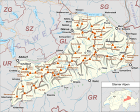
Glarus Alps
| Glarus Alps | |
|---|---|
|
Glarner Alpen | |
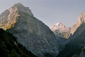
 Glarus Alps from Braunwald | |
| Highest point | |
| Peak | Tödi |
| Elevation | 3,614 m (11,857 ft) |
| Coordinates | 46°48′40″N 8°54′53″E / 46.81111°N 8.91472°E |
| Geography | |
 | |
| Country | Switzerland |
| Cantons | Glarus, Uri, Graubünden and St Gallen |
| Range coordinates | 46°55.9′N 8°54.9′E / 46.9317°N 8.9150°ECoordinates: 46°55.9′N 8°54.9′E / 46.9317°N 8.9150°E |
| Parent range | Western Alps |
| Borders on | |
| Topo map | Swiss Federal Office of Topography swisstopo |
| Geology | |
| Orogeny | Alpine orogeny |
The Glarus Alps (German: Glarner Alpen) are a mountain range in central Switzerland. They are bordered by the Uri Alps and the Schwyz Alps to the west, the Lepontine Alps to the south, the Appenzell Alps to the northeast. The eastern part of the Glarus Alps contains a major thrust fault which was declared a geologic UNESCO world heritage site (the Swiss Tectonic Arena Sardona).
The Glarus Alps extend well beyond the canton of Glarus, including parts of the cantons of Uri, Graubünden, and St Gallen. Conversely, not all the mountains in the canton of Glarus are part of the Glarus Alps, with those to the north of the Urner Boden and to the west of the valley of the river Linth considered to be part of the Schwyz Alps.
Geography
The main chain of the Glarus Alps can be divided into six minor groups, separated from each other by passes, the lowest of which exceeds 7,500 ft. The westernmost of these is the Crispalt, a rugged range including many peaks of nearly equal height. The highest of these are the Piz Giuv (3,096 m) and Piz Nair. The name Crispalt is given to a southern, but secondary, peak of Piz Giuv, measuring 3,070 m. West of the main group is the Rienzenstock, while a northern outlyer culminates in the Bristen. East of the Crispalt, the Chrüzli Pass separates this from the rather higher mass of the Oberalpstock (3,328 m).[1]
Here occurs a partial break in the continuity of the chain. The crest of the snowy range connecting the Oberalpstock with the Tödi nowhere sinks to 9,000 feet, but makes a sweep convex to the north, forming a semicircular recess, whose numerous torrents are all poured into the Rhine through the Val Russein below Disentis. Two glacier passes lead over this part of the chain — one to west, over the Brunnigletscher to the Maderanertal; the other to the north-east, over the Sand Glacier, to the Linthal.[1]
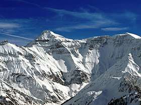
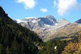
The Tödi, the highest of the range and of north-eastern Switzerland (3,614 m), is attended by numerous secondary peaks that arise from the extensive snow-fields surrounding the central mountain. A very considerable outlyer, whose chief summits are the Schärhorn and the Gross Windgällen, belonging to the canton of Uri, is connected with the Tödi by the range of the Clariden Grat, north to the Hüfi Glacier. A less important branch encloses the Biferten Glacier, and terminates in the Selbsanft, south of Tierfehd. Towards the valley of the Vorderrhein a high promontory stretches nearly due south from the central peaks of the Tödi, and is crowned by the summit of the Piz Posta Biala. Another considerable ramification of the same mass terminates farther to the east in the peak of the Cavistrau.[1]
The Kisten Pass separates the Tödi group from the Hausstock, whose summit attains 3,158 m; a branch of this latter group forms the range of the Kärpf in the canton of Glarus. The Hausstock is cut off from the rather lower but more extended mass of the Vorab by the Panixer Pass (7,907 ft). Numerous summits, of which the Vorab proper and Piz Grisch are the most important, approach very near, but do not quite attain to 10,000 feet.[1]
The eastern limit of the latter group is marked by the Segnas Pass — the most frequented of those connecting the Canton Glarus with the Vorderrhein — beyond which arises a wide-stretching mass of rock and glacier, which is part of the Glarus thrust and culminates at Piz Sardona. This mass is cleft by a deep valley — the Calfeisental: one branch, culminating in the Pizol (2,844 m), extends east over Pfäfers, while another, including the highest peak of the canton of St. Gallen, the Ringelspitz (3,247 m), runs due east to the low Kunkels Pass (1,357 m), separating this range from the Calanda.[1]
Principal summits

| Name | Altitude |
|---|---|
| Piz Russein (Tödi) | 3,613 metres (11,854 ft) |
| Bifertenstock | 3,419 metres (11,217 ft) |
| Piz Urlaun | 3,358 metres (11,017 ft) |
| Oberalpstock | 3,328 metres (10,919 ft) |
| Gross Schärhorn | 3,297 metres (10,817 ft) |
| Clariden | 3,267 metres (10,719 ft) |
| Gross Düssi | 3,256 metres (10,682 ft) |
| Cavistrau Grond | 3,251 metres (10,666 ft) |
| Ringelspitz | 3,247 metres (10,653 ft) |
| Gross Windgällen | 3,192 metres (10,472 ft) |
| Hausstock | 3,152 metres (10,341 ft) |
| Gross Ruchen | 3,136 metres (10,289 ft) |
| Ruchi | 3,107 metres (10,194 ft) |
| Piz Segnas | 3,102 metres (10,177 ft) |
| Piz Giuv | 3,098 metres (10,164 ft) |
| Hinderi Schibe | 3,083 metres (10,115 ft) |
| Crispalt | 3,080 metres (10,105 ft) |
| Bristen | 3,074 metres (10,085 ft) |
| Hinter Selbsanft | 3,028 metres (9,934 ft) |
| Bündner Vorab | 3,025 metres (9,925 ft) |
| Crap Mats | 2,947 metres (9,669 ft) |
| Piz Avat | 2,910 metres (9,547 ft) |
| Piz Ner | 2,859 metres (9,380 ft) |
| Tschingelhörner | 2,850 metres (9,350 ft) |
| Piz Sol Grauehorner | 2,849 metres (9,347 ft) |
| Calanda | 2,808 metres (9,213 ft) |
| Kärpf | 2,797 metres (9,177 ft) |
| Piz Alpetta | 2,764 metres (9,068 ft) |
| Piz Dado | 2,699 metres (8,855 ft) |
| Magerrain | 2,528 metres (8,294 ft) |
| Mürtschenstock | 2,442 metres (8,012 ft) |
| Fil da Rueun | 2,351 metres (7,713 ft) |
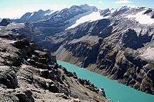
Glaciers
Main glaciers :
Passes
The chief passes of the Tödi Range, from the Oberalp Pass to the Klausen Pass, are:[2]
- Note: road status as of 1911.
| Mountain pass | Location | Type (as of 1911) | Elevation |
|---|---|---|---|
| Clariden Pass, Hüfi Pass | Maderanertal to Linthal | snow | 2,942 metres (9,652 ft) |
| Planura | Maderanertal to Linthal | snow | 2,921 metres (9,583 ft) |
| Chammlilücke | Maderanertal to Unterschächen | snow | 2,833 metres (9,295 ft) |
| Sardona Pass | Flims to Vättis | snow | 2,757 metres (9,045 ft) |
| Sand Alp Pass | Disentis to Linthal | snow | 2,780 metres (9,121 ft) |
| Brunni Pass | Disentis to Maderanertal | snow | 2,721 metres (8,927 ft) |
| Segnas Pass | Elm to Flims | foot path | 2,625 metres (8,612 ft) |
| Kisten Pass or Pass-Lembra | Linthal to Breil/Brigels | bad bridle path | 2,501 metres (8,205 ft) |
| Panixer Pass | Elm to Pigniu | bad bridle path | 2,407 metres (7,897 ft) |
| Chrüzli Pass | Maderanertal to Sedrun | foot path | 2,346 metres (7,697 ft) |
| Foo Pass | Elm to Weisstannen | bridle path | 2,222 metres (7,290 ft) |
| Oberalp Pass | Andermatt to Disentis | carriage road | 2,044 metres (6,706 ft) |
| Klausen Pass | Altdorf to Linthal | carriage road | 1,948 metres (6,391 ft) |
See also
References
- Swisstopo maps
Maps
- Swiss official cartography (Swiss Federal Office of Topography - Swisstopo); on-line version: map.geo.admin.ch
External links

- The Glarus Alps on SummitPost