Ligurian Alps
| Ligurian Alps | |
|---|---|
 | |
| Highest point | |
| Peak | Punta Marguareis |
| Elevation | 2,651 m (8,698 ft) |
| Geography | |
| Countries | Italy and France |
| Region, Région |
Piedmont Liguria Provence-Alpes-Côte d'Azur |
| Range coordinates | 44°10′N 8°5′E / 44.167°N 8.083°ECoordinates: 44°10′N 8°5′E / 44.167°N 8.083°E |
| Parent range | Alps |
| Borders on | Apennines and Maritime Alps |
| Geology | |
| Orogeny | Alpine orogeny |
The Ligurian Alps are a mountain range in northwestern Italy. A small part is located in France. They form the south-western extremity of the Alps, separated from the Apennines by the Colle di Cadibona. The Col de Tende separates them from the Maritime Alps. They form the border between Piedmont in the north and Liguria in the south.
Geography
Administratively the range is divided between the Italian provinces of Cuneo, Imperia and Savona and the French department of Alpes-Maritimes (south-western slopes).
The Ligurian Alps are drained by the Tanaro River, along with other tributaries of the Po River, on the Piedmontese side, and by several smaller rivers that flow directly to the Mediterranean Sea on the Ligurian and French side.
Chief peaks and passes

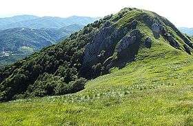
The chief peak of the Western Ligurian Alps is Punta Marguareis (2,651 m), and there are several other summits over 2000 m, while in Eastern Ligurian Alps (also called Ligurian Prealps[1]) the maximum elevation is 1739 m (Monte Armetta).
| Name | metres | feet |
|---|---|---|
| Punta Marguareis | 2,651 | 8,695 |
| Monte Mongioie | 2,630 | 8,626 |
| Cima delle Saline | 2,612 | 8,567 |
| Pizzo d'Ormea | 2,476 | 8,121 |
| Cima di Pertegà | 2,404 | 7,887 |
| Monte Besimauda | 2,231 | 7,317 |
| Monte Saccarello | 2,201 | 7,219 |
| Monte Frontè | 2,152 | 7,058 |
| Monte Antoroto | 2,144 | 7,032 |
| Monte Tanarello | 2,096 | 6,877 |
| Monte Monega | 1,882 | 6,175 |
| Bric Mindino | 1,879 | 6,163 |
| Monte Armetta | 1,739 | 5,703 |
| Monte Galero | 1,708 | 5,602 |
| Rocca delle Penne | 1,501 | 4,925 |
| Monte Carmo di Loano | 1,389 | 4,555 |
| Monte Settepani | 1,386 | 4,546 |
| Monte Spinarda | 1,357 | 4,453 |
| Rocca Barbena | 1,142 | 3,747 |
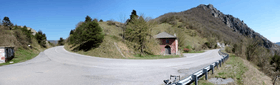
Some important passes in the Ligurian Alps are listed below.
| Name | Location | Type | Elevation |
|---|---|---|---|
| Colle di Cadibona | Savona to Ceva | highway | 436 m (1,430 ft) |
| Colle di Melogno | Finale Ligure to Ceva | road | 1,028 m (3,373 ft) |
| Giogo di Toirano | Toirano to Bardineto | road | 801 m (2,628 ft) |
| Colle Scravaion | Castelvecchio di Rocca Barbena to Bardineto | road | 814 m (2,671 ft) |
| Colle San Bernardo | Albenga to Garessio | road | 957 m (3,140 ft) |
| Colle di Nava | Imperia to Ormea | road | 934 m (3,064 ft) |
| Colle del Quazzo | Calizzano to Garessio | road | 1,090 m (3,580 ft) |
| Colle San Bernardo di Mendatica | Mendatica to Triora and Colle di Nava | road | 1,262 m (4,140 ft) |
| Col de Tende/Colle di Tenda | Tende to Cuneo | road | 1,870 m (6,140 ft) |
| Passo della Teglia | Molini di Triora to Rezzo | road | 1,385 m (4,544 ft) |
Conservation
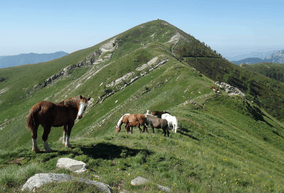
Around 60 square kilometres (23 sq mi) of the Ligurian side of the range since 2007 are part of the Parco naturale regionale delle Alpi Liguri.[2]
See also
Maps
- Italian official cartography (Istituto Geografico Militare - IGM); on-line version: www.pcn.minambiente.it
- French official cartography (Institut Géographique National - IGN); on-line version: www.geoportail.fr
References
- ↑ "1A1 Prealpi LIGURI". www.cailpv.bansel.it. Club Alpino Italiano of Liguria, Piedmont and Aosta Valley. Retrieved 2016-01-19.
- ↑ Storia del Parco, parconaturalealpiliguri.it
| Wikimedia Commons has media related to Ligurian Alps. |
| History |
|  | ||||
|---|---|---|---|---|---|---|
| Geography | ||||||
| Politics | ||||||
| Economy | ||||||
| Society |
| |||||