Cottian Alps
| Cottian Alps | |
|---|---|
| French: Alpes Cottiennes; Italian: Alpi Cozie | |
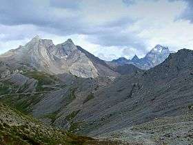
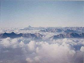 Monte Viso in the Cottian Alps, seen from the Rocciamelone | |
| Highest point | |
| Peak | Monte Viso |
| Elevation | 3,841 m (12,602 ft) |
| Coordinates | 44°40′18″N 7°15′13″E / 44.67167°N 7.25361°E |
| Geography | |
 Location
| |
| Countries | Italy and France |
| States/Provinces | Piedmont, Rhône-Alpes and Provence-Alpes-Côte d'Azur |
| Range coordinates | 44°45′N 7°0′E / 44.750°N 7.000°ECoordinates: 44°45′N 7°0′E / 44.750°N 7.000°E |
| Parent range | Alps |
| Borders on | |
| Geology | |
| Orogeny | Alpine orogeny |
The Cottian Alps (/ˈkɒtiən
Etymology
The name Cottian comes from Marcus Julius Cottius, a king of the tribes inhabiting that mountainous region in the 1st century BC. These tribes had previously opposed but later made peace with Julius Caesar. Cottius was succeeded by his son, also named Marcus Julius Cottius, who was granted the title of king by the emperor Claudius.
On his death, Nero annexed his kingdom as the province of Alpes Cottiae.[1]
History
For a long part of the Middle Ages the Cottian Alps were divided between the Duchy of Savoy, which controlled their northern part and the easternmost slopes, and the Dauphiné, which at the time was independent from France. The Dauphins also held, in addition to the southwestern slopes of the range (Briançon and Queyras, now on the French side), the upper part of some of the valleys that were tributaries of the Po River (Valle di Susa, Chisone valley, Varaita Valley). The Alpine territory of Dauphiné, known as Escartons, used to have a limited autonomy and elected its own parliament.[2] This semi-autonomous status lasted also after the annexation of the Dauphiné to France (1349), and was only abolished in 1713 due to the Treaty of Utrecht, which assigned to the House of Savoy all the mountainous area on the eastern side of the Cottian Alps.[3]
After the treaty annexing Nice and Savoy to France, signed in Turin in March 1860 (Treaty of Turin), the north-western slopes of the range became part of the French republic.[4]
Two eastern valleys of the Cottian Alps (Pellice and Germanasca) have been for centuries a kind of sanctuary for the Waldensians, a Christian movement founded by Peter Waldo and which was persecuted as heretical from the 12th century onwards.[5]
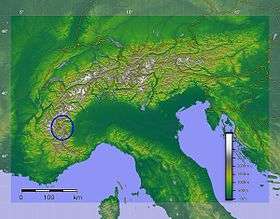
Geography
Administratively the range is divided between the Italian province of Cuneo and the Metropolitan City of Turin (the eastern slopes), and the French departments of Savoie, Hautes-Alpes, and Alpes-de-Haute-Provence (the western slopes).
The Cottian Alps are drained by the rivers Durance and Arc and their tributaries on the French side; and by the Dora Riparia and other tributaries of the Po on the Italian side.
Borders
The borders of the Cottian Alps are (clockwise):
- the Maddalena Pass to the south, which connects the Cottian Alps with the Maritime Alps;
- the Ubayette Valley, the Ubaye Valley, the Serre-Ponçon Lake, the high Durance Valley, and the Guisane Valley to the southwest;
- the Col du Galibier to the west, which connects the Cottian Alps with the Dauphiné Alps;
- the Valloirette Valley, the Maurienne Valley, and the Chardoux Creek to the northwest;
- the Mont Cenis Pass to the north, which connects the Cottian Alps with the Graian Alps;
- Mont Cenis Lake, the Cenischia Valley, the Dora Riparia Valley, the Po Plain, and the Varaita Valley to the east.
Peaks
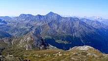
The chief peaks of the Cottian Alps are:
| name | metres | feet | name | metres | feet |
|---|---|---|---|---|---|
| Monte Viso | 3841 | 12,609 | Viso di Vallante | 3672 | 12,048 |
| Aiguille de Scolette | 3506 | 11,500 | Aiguille de Chambeyron | 3412 | 11,155 |
| Brec de Chambeyron | 3388 | 11,116 | Pics de la Font Sancte | 3387 | 11,112 |
| Rognosa d'Etiache | 3385 | 11,106 | Dents d'Ambin | 3382 | 11,096 |
| Punta Ferrand | 3364 | 11,037 | Visolotto | 3353 | 11,001 |
| Bric de Rubren | 3340 | 10,958 | Punta Sommeiller | 3333 | 10,935 |
| Pic de Rochebrune | 3320 | 10,891 | Bric Froid | 3302 | 10,833 |
| Grand Glaiza | 3286 | 10,781 | Rognosa di Sestriere | 3280 | 10,761 |
| Panestrel | 3253 | 10,673 | Roche du Grand Galibier | 3242 | 10,637 |
| Peou Roc | 3231 | 10,601 | Rocca Bernauda | 3225 | 10,581 |
| Grand Galibier | 3228 | 10,590 | |||
| Pic du Pelvat | 3218 | 10,558 | Pointe Haute de Mary | 3212 | 10,539 |
| Pain de Sucre | 3208 | 10,526 | Pic du Thabor | 3207 | 10,522 |
| Pointe des Cerces | 3180 | 10,434 | Mont Thabor | 3180 | 10,440 |
| Tete des Toillies | 3179 | 10,430 | Monte Granero | 3170 | 10,401 |
| Monte Platasse | 3149 | 10,331 | Rocce del Rouit | 3145 | 10,318 |
| Mont Chaberton | 3130 | 10,286 | Tete de Moyse | 3110 | 10,204 |
| Punta Bagnà | 3129 | 10,266 | Monte Meidassa | 3105 | 10,187 |
| Pelvo d'Elva | 3064 | 10,053 | Rocca Bianca | 3059 | 10,307 |
| Monte Albergian | 3041 | 9,977 | Bric Ghinivert | 3037 | 9,963 |
| Monte Barifreddo | 3028 | 9,933 | Monte Politri | 3026 | 9,928 |
| Pic Caramantran | 3025 | 9,925 | Bric Bouchet | 2998 | 9,836 |
| Pointe du Fréjus | 2934 | 9,626 | Pointe des Marcelettes | 2909 | 9,545 |
| Pic du Malrif | 2906 | 9,535 | Monte Orsiera | 2890 | 9,479 |
| Punta Cournour | 2868 | 9,410 | Monte Friolànd | 2738 | 8,981 |
Passes
The chief passes of the Cottian Alps are:
| name | location | type (as of 1911) |
elevation (m/ft) |
|---|---|---|---|
| Col Sommeiller | Bardonecchia to Bramans | snow | 2962/9718 |
| Col de la Traversette | Crissolo to Abriès | bridle path | 2950/9679 |
| Col d'Ambin | Exilles to Bramans | snow | 2854/9364 |
| Col de St Veran | Valle Varaita to the Queyras Valley | foot path | 2844/9331 |
| Col du Parpaillon | Ubaye Valley to the Queyras Valley | foot path | 2780/9121 |
| Col d'Étache | Bardonecchia to Bramans | bridle path | 2787/9144 |
| Col Agnel | Valle Varaita to the Queyras Valley | road | 2744/9003 |
| Col Girardin | Ubaye Valley to the Queyras Valley | bridle path | 2699/8855 |
| Col de Sautron | Valle Maira to Barcelonnette | bridle path | 2689/8823 |
| Col de Longet | Ubaye Valley to Valle Varaita | bridle path | 2672/8767 |
| Col de Mary | Ubaye Valley to Valle Maira | bridle path | 2654/8708 |
| Col d'Abriès | Perosa to Abriès | bridle path | 2650/8695 |
| Col de la Roue | Bardonecchia to Modane | bridle path | 2566/8419 |
| Col du Fréjus | Bardonecchia to Modane | dirt road | 2542/8340 |
| Col de Clapier | Bramans to Susa | bridle path | 2491/8173 |
| Col d'Izoard | Briançon to the Queyras Valley | road | 2388/7835 |
| Col de la Croix or Colle della Croce | Torre Pellice to Abriès | bridle path | 2299/7541 |
| Petit Mont Cenis | Bramans to the Mont Cenis Plateau | bridle path | 2184/7166 |
| Col de Vars | Ubaye Valley to the Queyras Valley | road | 2115/6939 |
| Mont Cenis | Lanslebourg to Susa | road | 2101/6893 |
| Colle Sestriere | Pinerolo to Cesana Torinese | road | 2021/6631 |
| Col de Larche/Maddalena Pass | Ubaye Valley to the Stura Valley | road | 1991/6532 |
| Col de Montgenèvre | Briançon to Susa | road | 1854/6083 |
| Col de l'Échelle | Briançon to Bardonecchia | road | 1760/5774 |
| Col de la Vallée Étroite | Briançon to Modane | foot path | 2445/8022 |
See also
- Alpes Cottiae (the original Roman province)
- Cottii Regnum
- Cottius
- Donnus
- Ambin group
Maps
- Italian official cartography (Istituto Geografico Militare - IGM); on-line version: www.pcn.minambiente.it
- French official cartography (Institut Géographique National - IGN); on-line version: www.geoportail.fr
References
![]()
- ↑ Bibliotheca classica or A classical dictionary, John Lemprière, G. and C. Carvill, 1831; pag. 414
- ↑ Escartons, hommes libres, www.escartons.eu (accessed on 2012-04-05)
- ↑ Joseph Visconti (2003). The Waldensian Way to God. Xulon Press.
- ↑ "Traité de Turin, Signé à Turin le 24 mars 1860 entre la France et la Sardaigne". mjp.univ-perp.fr. Retrieved 2010-01-01.
- ↑ Mennonite Encyclopedia, Vol. 4, pp. 874–876