Bains-les-Bains
| Bains-les-Bains | ||
|---|---|---|
| Commune | ||
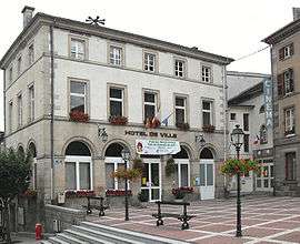 Town hall | ||
| ||
 Bains-les-Bains Location within Grand Est region  Bains-les-Bains | ||
| Coordinates: 48°00′11″N 6°15′51″E / 48.0031°N 6.2642°ECoordinates: 48°00′11″N 6°15′51″E / 48.0031°N 6.2642°E | ||
| Country | France | |
| Region | Grand Est | |
| Department | Vosges | |
| Arrondissement | Épinal | |
| Canton | Bains-les-Bains | |
| Intercommunality | Val de Vôge | |
| Government | ||
| • Mayor (2008–2014) | Frédéric Drevet | |
| Area1 | 25.37 km2 (9.80 sq mi) | |
| Population (2006)2 | 1,490 | |
| • Density | 59/km2 (150/sq mi) | |
| Time zone | UTC+1 (CET) | |
| • Summer (DST) | UTC+2 (CEST) | |
| INSEE/Postal code | 88029 /88240 | |
| Elevation |
256–417 m (840–1,368 ft) (avg. 325 m or 1,066 ft) | |
|
1 French Land Register data, which excludes lakes, ponds, glaciers > 1 km2 (0.386 sq mi or 247 acres) and river estuaries. 2 Population without double counting: residents of multiple communes (e.g., students and military personnel) only counted once. | ||

Bains-les-Bains is a commune in the Vosges department in Grand Est in eastern France. It is the administrative capital of the Canton of Bains-les-Bains.
Geography
The river Côney forms the commune's western border.
Points of interest
See also
External links
| Wikimedia Commons has media related to Bains-les-Bains. |
- (in French) Office de tourisme
- (in French) Commune website
| Authority control |
|---|
This article is issued from
Wikipedia.
The text is licensed under Creative Commons - Attribution - Sharealike.
Additional terms may apply for the media files.