Xonrupt-Longemer
| Xonrupt-Longemer | ||
|---|---|---|
| Commune | ||
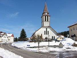 The centre of Xonrupt at the end of winter | ||
| ||
 Xonrupt-Longemer Location within Grand Est region  Xonrupt-Longemer | ||
| Coordinates: 48°05′N 6°56′E / 48.08°N 6.93°ECoordinates: 48°05′N 6°56′E / 48.08°N 6.93°E | ||
| Country | France | |
| Region | Grand Est | |
| Department | Vosges | |
| Arrondissement | Saint-Dié-des-Vosges | |
| Canton | Gérardmer | |
| Intercommunality | Communauté de communes des Hautes Vosges | |
| Government | ||
| • Mayor (2014-2020) | Michel Bertrand | |
| Area1 | 30.71 km2 (11.86 sq mi) | |
| Population (2014)2 | 1,555 | |
| • Density | 51/km2 (130/sq mi) | |
| Time zone | UTC+1 (CET) | |
| • Summer (DST) | UTC+2 (CEST) | |
| INSEE/Postal code | 88531 /88400 | |
| Elevation | 642–1,306 m (2,106–4,285 ft) | |
| Website | http://www.xonrupt.fr/ | |
|
1 French Land Register data, which excludes lakes, ponds, glaciers > 1 km2 (0.386 sq mi or 247 acres) and river estuaries. 2 Population without double counting: residents of multiple communes (e.g., students and military personnel) only counted once. | ||

Xonrupt-Longemer (French pronunciation: [ksɔ̃ʁy lɔ̃ʒmɛʁ]) is a commune in the Vosges department in Grand Est in northeastern France.
Points of interest
See also
References
| Wikimedia Commons has media related to Xonrupt-Longemer. |
This article is issued from
Wikipedia.
The text is licensed under Creative Commons - Attribution - Sharealike.
Additional terms may apply for the media files.