Saulxures-sur-Moselotte
| Saulxures-sur-Moselotte | ||
|---|---|---|
| Commune | ||
 | ||
| ||
 Saulxures-sur-Moselotte Location within Grand Est region  Saulxures-sur-Moselotte | ||
| Coordinates: 47°57′00″N 6°46′11″E / 47.95°N 6.7697°ECoordinates: 47°57′00″N 6°46′11″E / 47.95°N 6.7697°E | ||
| Country | France | |
| Region | Grand Est | |
| Department | Vosges | |
| Arrondissement | Épinal | |
| Canton | La Bresse | |
| Intercommunality | CC Hautes Vosges | |
| Government | ||
| • Mayor (2001–2008) | Marie-Thérèse Berranger | |
| Area1 | 31.87 km2 (12.31 sq mi) | |
| Population (2006)2 | 2,979 | |
| • Density | 93/km2 (240/sq mi) | |
| Time zone | UTC+1 (CET) | |
| • Summer (DST) | UTC+2 (CEST) | |
| INSEE/Postal code | 88447 /88290 | |
| Elevation |
430–1,005 m (1,411–3,297 ft) (avg. 464 m or 1,522 ft) | |
|
1 French Land Register data, which excludes lakes, ponds, glaciers > 1 km2 (0.386 sq mi or 247 acres) and river estuaries. 2 Population without double counting: residents of multiple communes (e.g., students and military personnel) only counted once. | ||

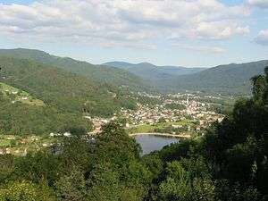
Saulxures-sur-Moselotte (German: Salzern) is a commune in the Vosges department in Grand Est in northeastern France.
It is situated between Remiremont and La Bresse, just off the D43 road, within the Parc Naturel Régional des Ballons.
The main local industries are timber, stone- and wood-working and textiles. Leisure activities offer walking in the wooded hills and the local lake.
See also
References
External links
| Wikimedia Commons has media related to Saulxures-sur-Moselotte. |
- Official site (in French)
This article is issued from
Wikipedia.
The text is licensed under Creative Commons - Attribution - Sharealike.
Additional terms may apply for the media files.