Étival-Clairefontaine
| Étival-Clairefontaine | ||
|---|---|---|
| Commune | ||
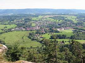 General view from Pierre d'Appel | ||
| ||
 Étival-Clairefontaine Location within Grand Est region  Étival-Clairefontaine | ||
| Coordinates: 48°21′53″N 6°51′32″E / 48.3647°N 6.8589°ECoordinates: 48°21′53″N 6°51′32″E / 48.3647°N 6.8589°E | ||
| Country | France | |
| Region | Grand Est | |
| Department | Vosges | |
| Arrondissement | Saint-Dié-des-Vosges | |
| Canton | Raon-l'Étape | |
| Intercommunality | CA Saint-Dié-des-Vosges | |
| Government | ||
| • Mayor (2008–2014) | Cécile Marchal | |
| Area1 | 27.12 km2 (10.47 sq mi) | |
| Population (2006)2 | 2,405 | |
| • Density | 89/km2 (230/sq mi) | |
| Time zone | UTC+1 (CET) | |
| • Summer (DST) | UTC+2 (CEST) | |
| INSEE/Postal code | 88165 /88480 | |
| Elevation |
285–591 m (935–1,939 ft) (avg. 302 m or 991 ft) | |
|
1 French Land Register data, which excludes lakes, ponds, glaciers > 1 km2 (0.386 sq mi or 247 acres) and river estuaries. 2 Population without double counting: residents of multiple communes (e.g., students and military personnel) only counted once. | ||

Étival-Clairefontaine is a commune in the Vosges department in Grand Est in northeastern France.
The Clairefontaine Paper Mill is located in this city.
The origins of Sanctivagium, altered in medieval Latin as Stivagium and Estival Old French, date back to the 7th century.
See also
References
External links
| Wikimedia Commons has media related to Étival-Clairefontaine. |
- Official website (in French)
This article is issued from
Wikipedia.
The text is licensed under Creative Commons - Attribution - Sharealike.
Additional terms may apply for the media files.