Valleroy-aux-Saules
| Valleroy-aux-Saules | |
|---|---|
| Commune | |
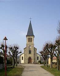 Saint-Brice | |
 Valleroy-aux-Saules Location within Grand Est region  Valleroy-aux-Saules | |
| Coordinates: 48°14′55″N 6°08′37″E / 48.2486°N 6.1436°ECoordinates: 48°14′55″N 6°08′37″E / 48.2486°N 6.1436°E | |
| Country | France |
| Region | Grand Est |
| Department | Vosges |
| Arrondissement | Neufchâteau |
| Canton | Mirecourt |
| Intercommunality | CC Mirecourt Dompaire |
| Government | |
| • Mayor (2008–2014) | Jean-Michel Gand |
| Area1 | 5.03 km2 (1.94 sq mi) |
| Population (2006)2 | 238 |
| • Density | 47/km2 (120/sq mi) |
| Time zone | UTC+1 (CET) |
| • Summer (DST) | UTC+2 (CEST) |
| INSEE/Postal code | 88489 /88270 |
| Elevation |
274–373 m (899–1,224 ft) (avg. 293 m or 961 ft) |
|
1 French Land Register data, which excludes lakes, ponds, glaciers > 1 km2 (0.386 sq mi or 247 acres) and river estuaries. 2 Population without double counting: residents of multiple communes (e.g., students and military personnel) only counted once. | |
Valleroy-aux-Saules is a commune in the Vosges department in Grand Est in northeastern France.
Geography
The river Madon flows through the commune.
See also
References
| Wikimedia Commons has media related to Valleroy-aux-Saules. |
This article is issued from
Wikipedia.
The text is licensed under Creative Commons - Attribution - Sharealike.
Additional terms may apply for the media files.