Côney
| Côney | |
|---|---|
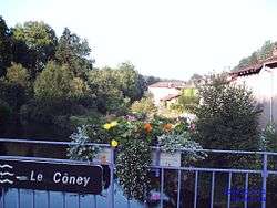 The Côney at Fontenoy-le-Château | |
| Country | France |
| Physical characteristics | |
| Main source |
Dounoux 425 m (1,394 ft) 48°07′14″N 06°25′56″E / 48.12056°N 6.43222°E |
| River mouth |
Saône 220 m (720 ft) 47°54′41″N 05°59′41″E / 47.91139°N 5.99472°ECoordinates: 47°54′41″N 05°59′41″E / 47.91139°N 5.99472°E |
| Length | 55 km (34 mi) |
| Discharge |
|
| Basin features | |
| Progression | Saône→ Rhône→ Mediterranean Sea |
| Basin size | 317 km2 (122 sq mi) |
The Côney (French: le Côney) is a 55-kilometre (34 mi) long river in the Vosges and Haute-Saône départements, northeastern France. Its source is near Lion Faing, a lieu-dit in Dounoux. It flows generally southwest. It is a left tributary of the Saône into which it flows in Corre.
It shares its valley with the canal de l'Est on most of its course.
Départements and communes along its course
This list is ordered from source to mouth:
- Vosges: Dounoux, Uriménil, Uzemain, Xertigny, Charmois-l'Orgueilleux, La Chapelle-aux-Bois, Harsault, Les Voivres, Hautmougey, Bains-les-Bains, Fontenoy-le-Château, Le Magny, Montmotier,
- Haute-Saône: Ambiévillers, Mailleroncourt-Saint-Pancras, Pont-du-Bois, Alaincourt, Selles, La Basse-Vaivre, Passavant-la-Rochère, Demangevelle, Vougécourt, Corre,
Notes
- This article is based on the equivalent article from the French Wikipedia, consulted on March 24th 2009.
References
| Wikimedia Commons has media related to Côney. |
This article is issued from
Wikipedia.
The text is licensed under Creative Commons - Attribution - Sharealike.
Additional terms may apply for the media files.