Plainfaing
| Plainfaing | ||
|---|---|---|
| Commune | ||
 | ||
| ||
 Plainfaing Location within Grand Est region  Plainfaing | ||
| Coordinates: 48°10′23″N 7°00′50″E / 48.173°N 7.014°ECoordinates: 48°10′23″N 7°00′50″E / 48.173°N 7.014°E | ||
| Country | France | |
| Region | Grand Est | |
| Department | Vosges | |
| Arrondissement | Saint-Dié-des-Vosges | |
| Canton | Gérardmer | |
| Intercommunality | CA Saint-Dié-des-Vosges | |
| Government | ||
| • Mayor (2008–2014) | Patrick Lalevée | |
| Area1 | 38.56 km2 (14.89 sq mi) | |
| Population (2006)2 | 1,854 | |
| • Density | 48/km2 (120/sq mi) | |
| Time zone | UTC+1 (CET) | |
| • Summer (DST) | UTC+2 (CEST) | |
| INSEE/Postal code | 88349 /88230 | |
| Elevation |
518–1,302 m (1,699–4,272 ft) (avg. 531 m or 1,742 ft) | |
|
1 French Land Register data, which excludes lakes, ponds, glaciers > 1 km2 (0.386 sq mi or 247 acres) and river estuaries. 2 Population without double counting: residents of multiple communes (e.g., students and military personnel) only counted once. | ||

Plainfaing is a commune in the Vosges department in Grand Est in northeastern France.
Geography
The commune is positioned in the east of the department, at the foot of the 949 meter high Bonhomme Pass (Col du Bonhomme), between Saint-Dié-des-Vosges (17 km / 11 Mi) to the west and Colmar (41 km / 26 Mi) in neighbouring Alsace to the east. The Meurthe River rises in the nearby commune of Le Valtin and crosses Plainfaing from the south, and is joined by the stream from the Chaume valley. A designated natural reserve of half a square kilometre is shared between Valtin and Plainfaing, and includes the peaks of the Tanet and the Gazon of the Faing.
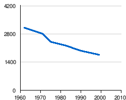
Demographic evolution
Born in Plainfaing
- Raymond Ruyer, philosopher
See also
References
| Wikimedia Commons has media related to Plainfaing. |