Xertigny
| Xertigny | ||
|---|---|---|
| Commune | ||
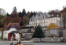 Chateau of the Brasseurs | ||
| ||
 Xertigny Location within Grand Est region  Xertigny | ||
| Coordinates: 48°02′46″N 6°24′24″E / 48.0461°N 6.4067°ECoordinates: 48°02′46″N 6°24′24″E / 48.0461°N 6.4067°E | ||
| Country | France | |
| Region | Grand Est | |
| Department | Vosges | |
| Arrondissement | Épinal | |
| Canton | Le Val-d'Ajol | |
| Intercommunality | Communauté d'agglomération d'Épinal | |
| Government | ||
| • Mayor (2014-2020) | Véronique Marcot | |
| Area1 | 50.25 km2 (19.40 sq mi) | |
| Population (2014)2 | 2,650 | |
| • Density | 53/km2 (140/sq mi) | |
| Time zone | UTC+1 (CET) | |
| • Summer (DST) | UTC+2 (CEST) | |
| INSEE/Postal code | 88530 /88220 | |
| Elevation |
297–617 m (974–2,024 ft) (avg. 461 m or 1,512 ft) | |
| Website | www.mairie-xertigny.fr | |
|
1 French Land Register data, which excludes lakes, ponds, glaciers > 1 km2 (0.386 sq mi or 247 acres) and river estuaries. 2 Population without double counting: residents of multiple communes (e.g., students and military personnel) only counted once. | ||

Xertigny (French pronunciation: [ksɛʁtiɲi]) is a commune in the Vosges department in Grand Est in northeastern France.
Geography
The Côney forms most of the commune's northwestern border.
Points of interest
See also
References
External links
| Wikimedia Commons has media related to Xertigny. |
This article is issued from
Wikipedia.
The text is licensed under Creative Commons - Attribution - Sharealike.
Additional terms may apply for the media files.