Brû
| Brû | ||
|---|---|---|
| Commune | ||
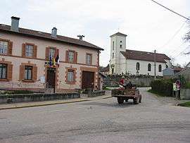 Town hall and the church | ||
| ||
 Brû Location within Grand Est region  Brû | ||
| Coordinates: 48°20′55″N 6°41′02″E / 48.3486°N 6.6839°ECoordinates: 48°20′55″N 6°41′02″E / 48.3486°N 6.6839°E | ||
| Country | France | |
| Region | Grand Est | |
| Department | Vosges | |
| Arrondissement | Épinal | |
| Canton | Raon-l'Étape | |
| Intercommunality | CC Région de Rambervillers | |
| Government | ||
| • Mayor (2008–2017) | Alain Gérard | |
| Area1 | 8.95 km2 (3.46 sq mi) | |
| Population (2006)2 | 625 | |
| • Density | 70/km2 (180/sq mi) | |
| Time zone | UTC+1 (CET) | |
| • Summer (DST) | UTC+2 (CEST) | |
| INSEE/Postal code | 88077 /88700 | |
| Elevation |
295–391 m (968–1,283 ft) (avg. 311 m or 1,020 ft) | |
|
1 French Land Register data, which excludes lakes, ponds, glaciers > 1 km2 (0.386 sq mi or 247 acres) and river estuaries. 2 Population without double counting: residents of multiple communes (e.g., students and military personnel) only counted once. | ||

Brû is a commune in the Vosges department in Grand Est in northeastern France.
See also
References
| Wikimedia Commons has media related to Brû. |
This article is issued from
Wikipedia.
The text is licensed under Creative Commons - Attribution - Sharealike.
Additional terms may apply for the media files.