Girancourt
| Girancourt | ||
|---|---|---|
| Commune | ||
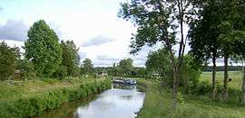 Canal de l'Est | ||
| ||
 Girancourt Location within Grand Est region  Girancourt | ||
| Coordinates: 48°09′51″N 6°18′30″E / 48.1642°N 6.3083°ECoordinates: 48°09′51″N 6°18′30″E / 48.1642°N 6.3083°E | ||
| Country | France | |
| Region | Grand Est | |
| Department | Vosges | |
| Arrondissement | Épinal | |
| Canton | Darney | |
| Intercommunality | CA Épinal | |
| Government | ||
| • Mayor (2008–2014) | Yannick Villemin | |
| Area1 | 17.66 km2 (6.82 sq mi) | |
| Population (2006)2 | 852 | |
| • Density | 48/km2 (120/sq mi) | |
| Time zone | UTC+1 (CET) | |
| • Summer (DST) | UTC+2 (CEST) | |
| INSEE/Postal code | 88201 /88390 | |
| Elevation |
337–461 m (1,106–1,512 ft) (avg. 352 m or 1,155 ft) | |
|
1 French Land Register data, which excludes lakes, ponds, glaciers > 1 km2 (0.386 sq mi or 247 acres) and river estuaries. 2 Population without double counting: residents of multiple communes (e.g., students and military personnel) only counted once. | ||

Girancourt is a commune in the Vosges department in Grand Est in northeastern France.
See also
References
| Wikimedia Commons has media related to Girancourt. |
This article is issued from
Wikipedia.
The text is licensed under Creative Commons - Attribution - Sharealike.
Additional terms may apply for the media files.