Morizécourt
| Morizécourt | |
|---|---|
| Commune | |
 | |
 Morizécourt Location within Grand Est region  Morizécourt | |
| Coordinates: 48°04′16″N 5°51′40″E / 48.0711°N 5.8611°ECoordinates: 48°04′16″N 5°51′40″E / 48.0711°N 5.8611°E | |
| Country | France |
| Region | Grand Est |
| Department | Vosges |
| Arrondissement | Neufchâteau |
| Canton | Darney |
| Intercommunality | CC Vosges côté Sud-Ouest |
| Government | |
| • Mayor (2007–2014) | Laurent Destrignéville |
| Area1 | 10.68 km2 (4.12 sq mi) |
| Population (2006)2 | 133 |
| • Density | 12/km2 (32/sq mi) |
| Time zone | UTC+1 (CET) |
| • Summer (DST) | UTC+2 (CEST) |
| INSEE/Postal code | 88314 /88320 |
| Elevation |
279–422 m (915–1,385 ft) (avg. 350 m or 1,150 ft) |
|
1 French Land Register data, which excludes lakes, ponds, glaciers > 1 km2 (0.386 sq mi or 247 acres) and river estuaries. 2 Population without double counting: residents of multiple communes (e.g., students and military personnel) only counted once. | |
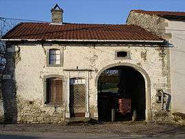
Morizécourt is a commune in the Vosges department in Grand Est in northeastern France.
The Benedictine priory at Morizécourt dates from 1624.
See also
References
| Wikimedia Commons has media related to Morizécourt. |
This article is issued from
Wikipedia.
The text is licensed under Creative Commons - Attribution - Sharealike.
Additional terms may apply for the media files.