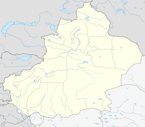
Artux
| Artux 阿图什市 ئاتۇش شەھىرى | |
|---|---|
| County-level city | |
 Artux Location in Xinjiang | |
| Coordinates: 39°42′0″N 76°09′15.79″E / 39.70000°N 76.1543861°ECoordinates: 39°42′0″N 76°09′15.79″E / 39.70000°N 76.1543861°E | |
| Country | People's Republic of China |
| Autonomous region | Xinjiang |
| Prefecture | Kizilsu (Kirghiz) |
| Area | |
| • Total | 15,698 km2 (6,061 sq mi) |
| Population (2003) | |
| • Total | 210,000 |
| • Density | 13/km2 (35/sq mi) |
| Artux | |||||||||||
| Chinese name | |||||||||||
|---|---|---|---|---|---|---|---|---|---|---|---|
| Simplified Chinese | 阿图什 | ||||||||||
| Traditional Chinese | 阿圖什 | ||||||||||
| |||||||||||
| Uyghur name | |||||||||||
| Uyghur |
ئاتۇش | ||||||||||
| |||||||||||
| Kyrgyz name | |||||||||||
| Kyrgyz |
ارتىش Артыш Artış | ||||||||||
Artux[1] transliterated from Kyrgyz, is a county-level city in Xinjiang. The area is 15,509 km2 (5,988 sq mi) and the total population is 200,000 (2002). Artux is the seat of Kizilsu Kirghiz Autonomous Prefecture.
Geography and climate
It is situated in the northwest part of the Tarim Basin, south of the Tien Shan mountains. The city's annual mean temperature is 12.0 °C (53.6 °F), precipitation 80 mm (3.1 in).
Economy
Artux's economy is primarily agriculture, the agricultural products are mainly cotton, grapes, and sheep.
Transportation
Artux is served by the Southern Xinjiang Railway.
References
- ↑ The official spelling according to Zhōngguó dìmínglù 中国地名录 (Beijing, SinoMaps Press 中国地图出版社 1997); ISBN 7-5031-1718-4
This article is issued from
Wikipedia.
The text is licensed under Creative Commons - Attribution - Sharealike.
Additional terms may apply for the media files.